Sunday, March 26, 2023

Orlando, Florida

It had been two years since the family was able to connect with Mia, so we decided to fly across the country to visit with her and meet her boyfriend, Mike, in Orlando, Florida during Northshore School District's Mid-Winter Break, as that was a week that Suzanne could take off from seminary.  

It was great to spend quality time as a family, get familiar with Florida, see some of the attractions in the area, and also relax at Mike and Mia's home with some board games, movies, and great food.  

Blue Springs State Park - We saw several manatees as well as an alligator at this spring with crystal clear water.

Space Shuttle Atlantis at Kennedy Space Center

Activities

Harry P Leu Gardens

While our hike We spent about 2.5 hours at this sprawling garden setting on Lake Rowena in Orlando.  It has a wide array of trees, ferns, flowers, and succulents.  Adding to the setting were quaint homes, restful gazebos, terraced patios, and water fountains.  We enjoyed views of the lake, and couldn't help but gawk at some of the intricate flowers and oddly patterned tree trunks.
  • 1.07 mi
    Distance
  •  
  • 42:31
    Moving Time
  •  
  • 39:28 /mi
    Pace


Located on the shore of Lake Sybellia in Maitland, Florida, we visited this facility that houses rescued raptors.  We knew it was going to be a special place when we were greeted at the ticket counter by a blind bald eagle that volunteers read to.  We saw vultures, falcons, hawks, and owls among many other birds, both large and small.  We also saw turtles among the lily pads of the lake.

Kelly Park / Rock Springs

This popular destination for floating in crystal clear waters made for an enjoyable 1.2-mile hike.  The trail took us directly to the cave from which the head of the spring emanates.  The path is lined with tall trees and ferns.

  • 1.20 mi
    Distance
  •  
  • 34:53
    Moving Time
  •  
  • 29:03 /mi
    Pace

Space Coast

On Friday, February 17th, we took the hour and a half drive east from Orlando to visit the Kennedy Space Center.  We oohed and aahed at all of the exhibits, displays, rockets, artifacts, and history of NASA's primary launch facility.  We saw glimpses of the future of space travel on display, as well as a plethora of space-flown items on display, such as the Apollo 14 capsule, the Gemini 9A capsule, and Gene Cernan's spacesuit from the Apollo 17 mission.  It is the last spacesuit to touch the Moon, back in 1972.  We also saw the massive Saturn V Rocket, and Atlantis Space Shuttle.  As if that isn't enough, the entire Apollo 11 control room is also on display, including all of the original equipment in its original configuration from the 1969 mission that landed Neil Armstrong and Buzz Aldrin on the Moon.

After spending several hours at the visitor complex, we drove to Cocoa Beach to feel Florida sand and touch the Atlantic Ocean, a first for all of us.  Even though we arrived at 6pm, there were still quite a few people at the beach, enjoying a pleasant evening of surfing, swimming, and beachcombing.

The day finished up with an actual SpaceX rocket launch of the Falcon 9 rocket carrying the Inmarsat I-6 F2 payload.  We waited a couple of hours at a viewing area about 12 miles away from Space Launch Complex 40.  We enjoyed seeing a rocket launch live as it lit up the entire night sky, but a low cloud cover meant we could only see the rocket for a few seconds before disappearing.  

Blue Springs State Park

After watching a rocket launch late on Friday evening and then driving back to Florida, we got little sleep that night, as we decided to wake up early on Saturday morning, because the weather forecast gave us our best opportunity to see manatees at Blue Springs State Park.  We ended up spotting several manatees, all of which had been recently released.  Each of them had trackers and buoys on them that made them easier to spot above water.  Unfortunately, it was difficult to get a decent picture of them from the viewpoints where we saw them, but it was awesome to see such large, graceful creatures in the clear spring water.  As a bonus, we even got to see an alligator in the wild.  Fortunately, they were on the other side of the spring, sunning on a log, so we were able to admire it without feeling threatened by its presence.

  • 0.98 mi
    Distance
  •  
  • 30:16
    Moving Time
  •  
  • 30:43 /mi
    Pace

Walt Disney World's Animal Kingdom

We figured that as long as we were in Orlando, we had better do at least one theme park, so we opted to do Disney's Animal Kingdom this time around.  Part zoo, part amusement park, we spent nearly 12 hours exploring the park and waiting in lines.  We were surprised at how crowded WDW can be even in February!  Here is what everyone said their favorite attraction was:


Walk Details:
  • 3.96 mi
    Distance
  •  
  • 2:02:19
    Moving Time
  •  
  • 30:53 /mi
    Pace

Ripley's Believe It or Not Museum

One of the weirder attractions we visited was the eclectic Ripley's museum in Orlando.  From intricate matchstick models to large carved horns, a flight suit signed by Buzz Aldrin, and Han Solo's blaster, you really never knew what (or even why!) you were going to see around the next corner of this place.

Showcase of Citrus

No visit to Florida would be complete without a visit to a citrus farm!  We visited the Showcase, which is one of Central Florida's most popular farm attraction, complete with farm (and not so farm) animals.  We enjoyed fresh squeezed citrus slushees from the bar, and Dad even spotted a favorite childhood beverage that he hasn't seen in many years.

Favorites

Here is what each family member said their favorite activity was:

Person   Favorite
Mom Manatees at Blue Springs
DadKennedy Space Center
Mike:Playing Board Games (especially Hot Seat) 
MiaManatees at Blue Springs
Raymond  Feathered Friends of Flight

Photos and Videos


Saturday, August 27, 2022

Spider Gap - Buck Creek Loop (2022)

Almost a decade ago, Mike went on his first 50-mile backpacking trip with BSA troop 525.  The trip was so spectacular, that when he was invited to repeat this itinerary with friends Ted and Dave, he said "Absoutely!"  The Spider Gap / Buck Creek Loop in the Glacier Peak Wilderness has some of the most amazing scenery of Washington's Cascade Mountain range.  But, don't take his word for it, look at the photo gallery from the trip and decide for yourself.

It is agonizingly difficult to come up with a picture or two that can act as cover pictures for this blog, but Mike settled on showing the views from the campsites.  

Campsite on Larch Knob overseeing Spider Meadow and the Phelps Creek Basin

Sunrise on Glacier Peak from campsite at Buck Creek Pass


Report


Day 1 (8.4 miles / 2411 feet of ascent): Starting from the Phelps Creek Trailhead from the Okanogan-Wenatchee National Forest, the trio began their hike with a sneak peak of the type of views they would enjoy during the trip.  After a couple of miles of gradual ascent they entered Glacier Peak Wilderness.  The next few miles would be a gentle amble through the forest, with several creek crossings, until arriving at the first gem of the trip:  Spider Meadow.  The U-shaped valley is evidence of the massive Spider Glacier that once carved this valley into the beauty that it is today.  After a casual lunch at the meadow, they picked their jaws off the ground and made the arduous ascent up to Larch Knob, where they camped with views of Spider Meadow from high above the valley floor.

Day 2 (7.1 miles / 1803 feet of ascent): To say that day 2 was the shortest mileage of the trip doesn't do justice to the difficulty of the terrain.  They first had to slog up Spider Glacier, avoiding a crevasse along the way.  At the top of Spider Gap, they were treated to views of Lyman Lakes Basin and Chiwawa Mountain.  Past Upper Lyman Lake, they had to ford Railroad Creek before descending along the Lyman Falls to Lower Lyman Lake.  Finding ripe, delicious mountain huckleberries in the lower part of the basin made for some slow going, as the temptation to stop often and pop a few in their mouths was just too great.  Eventually, however, they made it to the campsite at Cloudy Pass before sunset, but the bugs drove them into our tents fairly early in the evening.

Day 3 (11.0 miles / 4724 feet of ascent): A day of literal ups and downs, they had to climb up to Cloudy Pass with spectacular views of Spider Gap and the Lyman Lakes Basin to the south and their first glimpse of Glacier Peak, after which came Suiattle Pass and our overlap of the Pacific Crest Trail.  It was here where they met a through-hiker named Steve (trail name: Rocky).  His YouTube channel catalogs his hike from the Mexican border to the Canadian Border and also features a cameo of Dave, Ted, and Mike.  They passed several other through hikers on the long descent to Miner's Creek, which included a choose-your-own adventure route over an avalanche field of downed trees. After leaving the PCT, it was an arduous ascent to Middle Ridge.  One would have hoped that three passes were enough for one day, but no... they still had to drop down to Small Creek and finish at Buck Creek Pass, where they set up camp with a perfect view of Glacier Peak.

Day 4 (10.7 miles / 945 feet of ascent):  The sprint to the end of the trail was mostly downhill to the old mining town of Trinity, WA.  Of course, they didn't sprint, because there were still too many photo opportunities to pass by.  By the time they had reached Trinty, the temperature was in the 80s, made all too apparent by how exposed the trail was, especially the recent fire burn area where wildflowers were taking full advantage of the newfound sunlight.

Daily Itinerary

Distance (miles)


Elev. Gain
(ft)

Phelps Creek TR to Larch Knob8.42411
Larch Knob to Cloudy Pass7.11803
Cloudy Pass to Buck Creek Pass11.04724
Buck Creek Pass to Trinity10.7 945
TOTALS 37.29883

The wildflowers were amazing.  Our trip may have been past peak for some of the higher elevation meadows, but we saw a burst of color in the lower meadows, including all of the following:
  • Aster
  • Pearly Everlasting
  • Mountain Arnica
  • Magenta Paintbrush
  • Wenatchee Paintbrush
  • Giant Red Paintbrush
  • Howell's Pussytoes
  • Subalpline Lupen
  • Reb Willowherb
  • Moutain Bog Gentain
  • Fireweed
  • Bear Grass

Photos

Here is Mike's online photos.  A more complete album including Ted and Dave's pictures is here.  A playlist of GoPro videos are also available on YouTube.

GPS Info


Flythrough Maps


Dave produced the following 3D maps of each day from his Suunto watch:

Overview Map


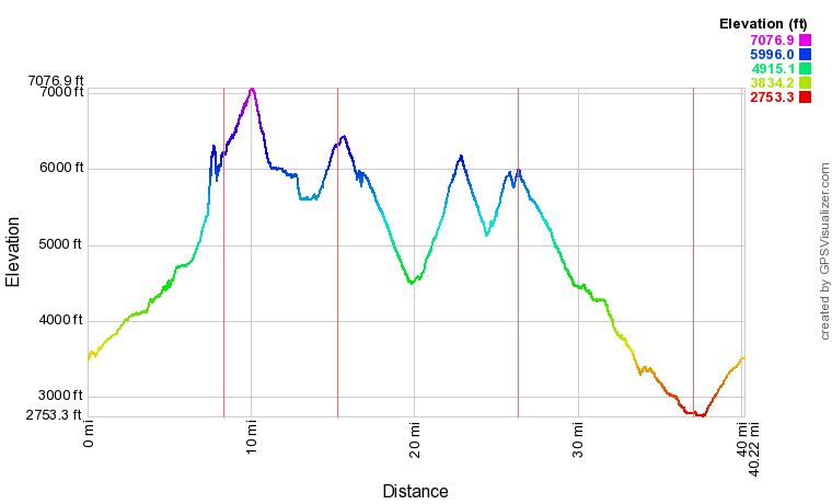
Elevation Profile


If you would like to use this info with your GPS unit, the full GPX file is here.


Wednesday, August 10, 2022

Sucia Island

Ahead of their 27th wedding anniversary, Suzanne and Mike took a trip to Sucia Island State Park, a member of the San Juan Islands in the Strait of Georgia.  Because there is no state ferry service to Sucia Island, most visit the island by private boat.  Because they don't have a boat, Mike and Suzanne got to their campground with a bit more logistical preparation that required them to:

  1. Drive from their home to Anacortes, WA
  2. Board the ferry from Anacortes to Orcas Island
  3. Drive to Eastsound, WA on the north side of Orcas.
  4. Board a water taxi to Sucia Island
  5. Backpack their camping gear from Fossil Bay to North Echo Bay
  6. Hike back to Fossil Bay to prepare the kayak
  7. Paddle from Fossil Bay to Mud Bay
  8. Portage across the spit from Mud Bay to Snoring Bay
  9. Paddle from Snoring Bay to campsite at North Echo Bay via South Finger and Justice Islands
They left home at 5am and were finally set up at camp with their kayak on shore at 3:15pm.  

Sucia is a beautiful island chocked full of gravelly beaches, hidden coves, large bays, intricate rock formations, forested paths, bluffs with expansive vistas, tranquil sunsets, and thrilling wildlife.  They saw otters, seals, herons, gulls, cormorants, eagles (along with a ridiculously large nest,) bats, snakes, lizards, mice (keep your food very secure on Sucia!), and naturally, plenty of ants and mosquitoes.


Dusk on Fossil Bay with Mount Baker in the background

Activities


The focus of this itinerary was threefold:  kayaking, hiking, and relaxing.  Hiking would typically happen in the morning, with kayaking in the afternoon, and relaxing in the evenings, watching the sunset and enjoying the view from the campsite.  They collected the following details from their GPS:


Activity

Distance (miles)


Elev. Gain
(ft)

Backpacking    2.7 550
Hiking 16.2 2420
Kayaking  8.7 --
TOTALS  27.6 2970

Map

The following are the maps of hiking and paddling along with a GPX file with all of these hikes.  The maps and profiles are all produced by GPS Visualizer.  

Hiking


Kayaking


Profiles

Hiking Elevation

Kayaking Speed

Highlights

For a remote island accessible by boat only, the Washington State Parks service does a great job at maintaining the facilities.  The compost toilets were always clean, and the campsites well maintained.  The staff were occasionally spotted on their John Deere tractor, and they were all very friendly.  When they saw pedestrians on the trail, they would come to a complete stop until passed to keep dust off of visitors.

Favorites

  • Mike: Enjoying the expansive scenery of the Georgia Strait, with boats, otters, seals, and birds enjoying the waters during sunset.
  • Suzanne: Exploring the rocky coastline via kayak.

Lowlights

The biggest misfortune on the trip was Suzanne's fall that injured her right elbow.  Because she was no longer able to paddle, they had to limit their kayaking distance, since Mike had to do all of the paddling.  As a result, they weren't able to explore some of the areas they had hoped to.  

The mosquitos were annoying as well.  The bug spray did a reasonable job of keeping them from attacking, but both were bitten several times.  

Photos

There are 160 photos and a video of one kayak outing, which traversed Fossil Bay, Shallow Bay, and Fox Cove.  Click the links to view them all.

Saturday, July 16, 2022

Sammamish River Kayak (Woodinville)

It has been a while since the kayak has come out of its bag, and since Suzanne and I are planning a kayaking trip on Sucia Island next month, we figured we should break it out to make sure everything was in working order.  We launched at Brackett's Landing and travelled upstream past Wilmot Gateway Park in Woodinville.  We spotted a blue heron and a river otter that came up out of the water for the briefest of moments.  There were relatively few paddlers that direction, as most tend to stay closer to Bothell Landing.

Sammamish River vegetation in Woodinville.

GPS Info

We collected all of the following data from our GPS unit during the adventure:

Maps


This Leaflet Map is provided by GPS Visualizer


Speed Profile


From the following profile, it's evident that we went upstream first, but the Sammamish River is so calm that the currents don't really hold back too much.  There was one section where we had to paddle hard to overcome the current of an incoming stream, but for the most part, this was a very easy paddle.


This profile is provided by GPS Visualizer

• Mileage: 4.5 mi
• Time: 1:43:15
• Speed: 2.6 MPH
• Put-in Coordinates: 47.7546, -122.1935


Photos

While this trip was really intended to be a gear check, we did take a few photos of the river that can be seen here.


Saturday, July 9, 2022

Greider Lakes

For my next training hike, I opted to revisit Greider Lakes in the Morning Star Natural Resources Conservation Area.  The day started out mostly sunny at the trailhead on Spada Lake, but as I reached the pair of alpine lakes, the clouds had come in and greyed everything out.  Of course, as I headed back down the trail, the skies opened up again.  For a second straight hike, I was foiled in being able to capture the beauty of  Washington's alpine lakes.  

But, the point of this hike really was to assess my readiness for a multi-day backpack to Glacier Peak Wilderness next month.  The sole purpose was the test of a 9.2 mile round-trip hike with 2500 feet of elevation gain, most of which comes over 40 switchbacks that cover 1.5 miles of trail.  Much less crowded than Serene Lake, I only saw about 50 hikers in my 6.5 hours on the trail.

There were some awesome wildflowers to enjoy along the trail as well.  With a book that Suzanne recently gave me, "Wildflowers of the Pacific Northwest", I was able to identify the following:

  • Dwarf Dogwood
  • Red Columbine
  • Foxglove
  • Common Dandelion
  • Daisy (Not sure what kind... would need a better picture to identify)


Little Greider Lake


Big Greider Lake

GPS Info

Here is the data from the GPS unit:

Maps


This Leaflet Map is provided by GPS Visualizer


Elevation Profile


This profile is provided by GPS Visualizer

Coordinates and other details


  • Mileage:
  • 9.2 Miles
  • Elevation
  • 2537 Feet
  • Time:
  • 6:45:56 (total), 4:40:50 (moving)
  • Average Speed:
  • 1.36 MPH (total), 1.96 MPH (moving)
  • Trailhead Coordinates:
  • 47.9741, -121.6136

    The GPX file can be downloaded here.

    Photos and Videos


    Photos are available at this album, while a YouTube video is available here.

    Monday, July 4, 2022

    Serene Lake / Bridal Veil Falls

    In an effort to assess physical preparedness for a possible multi-day backpacking trip in August, Mike loaded up his pack with 30 pounds of gear for a day hike to Serene Lake and Bridal Veil Falls on the Fourth of July.  Chosen for its difficulty, this hike was 8.6 miles round-trip with 3000 feet of elevation ascent.   Knowing of the popularity of this destination, Mike arrived at the trailhead at 6:45 AM for easy parking--only 10 other cars were there at that time of the morning.

    Trying to keep count of hikers along the way, he counted approximately 250 on the hike to and from Serene Lake, and another 150 past Bridal Veil falls!  That's a lot of hikers on one trail as attested by the fact that both parking lots filled, and cars still had to park along the forest road as well.


    Bridal Veil Falls

    Bridal Veil Falls (East Cascade)

    GPS Info

    Here is the data from the GPS unit:

    Maps


    This Leaflet Map is provided by GPS Visualizer


    Elevation Profile


    This profile is provided by GPS Visualizer


    Coordinates and other details


  • Mileage:
  • 8.6 Miles
  • Elevation
  • 2904 Feet
  • Time:
  • 6:32:02 (total), 4:47:58 (moving)
  • Average Speed:
  • 1.31 MPH (total), 1.78 MPH (moving)
  • Trailhead Coordinates:
  • N 47° 48.553, W 121° 34.400

    The GPX file can be downloaded here.

    Photos and Videos


    Photos are available at this album, while a YouTube video is available here.


    Sunday, June 26, 2022

    Oregon Waterfall Tour and Portland

    For our vacation this year, we booked a glamping experience at an airbnb near Portland, Oregon to give us an opportunity to hunt for waterfalls in the Columbia River Gorge, explore Portland, and pay a brief visit to the Oregon coast.  It was a quick trip, lasting just a few days, but it was packed with over one thousand miles of driving and about twenty miles of walking and hiking.  We dedicated a couple of days to Portland, and a couple of days to the gorge, one day on the Washington state side, and the other in Oregon.

    The middle of June is a bit earlier than we would normally like to vacation in the Pacific Northwest, especially this year, where our Spring was colder, grayer, and rainier than normal, but we got really lucky with the weather.  However, this week was the only window of opportunity all three of us had to be able to make it happen.  It rained on our drive to and from Oregon as well as a couple of nights, but during our daytime explorations, we experienced heavily overcast skies with just a few rare sprinkles, and temperatures in the high 50s to low 60s.


    Multnomah Falls, Colubmia River Gorge National Scenic Area


    Mount Hood

    Activities

    Oregon Coast

    On our drive to Oregon, the radar informed us that it was raining inland, but not on the Oregon coast, so we drove through Astoria, Oregon, the widest crossing of the Columbia River between Washington and Oregon.  I timed our crossing at four minutes, travelling at 55 MPH.  A Google Map confirms that the bridge is 3.7 miles long.  We made the following stops on our drive:

    Portland

    In Portland, we did a three-mile walking tour of the city, which featured the following highlights:

    Waterfalls

    Thirteen waterfalls on this trip.  With more time, we could've seen many more, but we prioritized low-hanging fruit (easy, short hikes.)  

    • WA Side of Columbia River Gorge: #1 - #4
    • OR Side of Columbia River Gorge: #5 - #11
    • Hood Valley: #12 - #13
    Each link below contains a photo of each waterfall.
        

    Monday (Portland) Tuesday (Columbia Gorge - WA side) Wednesday (Columbia Gorge - OR side) Thursday (Portland)
    Raymond: Powell's City of Books Beacon Rock Hike Latourell Falls Rhododendrom Garden (waterfalls and waterfowl)
    Suzanne: Lan Su Chinese Garden Dog Creek Falls Upper Horsetail Falls Rhododendrom Garden (bridge)
    Mike: Lan Su Chinese Garden Beacon Rock Hike Upper Horsetail Falls Rhododendrom Garden (flowers and blossoms)

    Photos & Videos

    Washington to Florida

    After living in Washington state for 17 years, we decided to move to the extreme opposite end of the country to be with Mia and Mike as they...