Almost a decade ago, Mike went on his first 50-mile backpacking trip with BSA troop 525. The trip was so spectacular, that when he was invited to repeat this itinerary with friends Ted and Dave, he said "Absoutely!" The Spider Gap / Buck Creek Loop in the Glacier Peak Wilderness has some of the most amazing scenery of Washington's Cascade Mountain range. But, don't take his word for it, look at the photo gallery from the trip and decide for yourself.
It is agonizingly difficult to come up with a picture or two that can act as cover pictures for this blog, but Mike settled on showing the views from the campsites.
Campsite on Larch Knob overseeing Spider Meadow and the Phelps Creek BasinSunrise on Glacier Peak from campsite at Buck Creek Pass
Report
Day 1 (
8.4 miles / 2411 feet of ascent): Starting from the
Phelps Creek Trailhead from the
Okanogan-Wenatchee National Forest, the trio began their hike with
a sneak peak of the type of views they would enjoy during the trip. After a couple of miles of gradual ascent they entered Glacier Peak Wilderness. The next few miles would be a gentle amble through the forest, with several
creek crossings, until arriving at the first gem of the trip:
Spider Meadow. The
U-shaped valley is evidence of the massive Spider Glacier that once carved this valley into the beauty that it is today. After a casual lunch at the meadow, they picked their jaws off the ground and made the arduous ascent up to
Larch Knob, where they camped with
views of Spider Meadow from high above the valley floor.
Day 2 (
7.1 miles / 1803 feet of ascent): To say that day 2 was the shortest mileage of the trip doesn't do justice to the difficulty of the terrain. They first had to slog up
Spider Glacier, avoiding a
crevasse along the way. At the top of
Spider Gap, they were treated to views of
Lyman Lakes Basin and
Chiwawa Mountain. Past
Upper Lyman Lake, they had to ford
Railroad Creek before descending along the
Lyman Falls to
Lower Lyman Lake. Finding ripe, delicious
mountain huckleberries in the lower part of the basin made for some slow going, as the temptation to stop often and pop a few in their mouths was just too great. Eventually, however, they made it to the campsite at Cloudy Pass before sunset, but the bugs drove them into our tents fairly early in the evening.
| Daily Itinerary | Distance (miles) |
Elev. Gain
(ft)
|
| Phelps Creek TR to Larch Knob | 8.4 | 2411 |
| Larch Knob to Cloudy Pass | 7.1 | 1803 |
| Cloudy Pass to Buck Creek Pass | 11.0 | 4724 |
| Buck Creek Pass to Trinity | 10.7 | 945 |
| TOTALS | 37.2 | 9883 |
The wildflowers were amazing. Our trip may have been past peak for some of the higher elevation meadows, but we saw a burst of color in the lower meadows, including all of the following:
- Aster
- Pearly Everlasting
- Mountain Arnica
- Magenta Paintbrush
- Wenatchee Paintbrush
- Giant Red Paintbrush
- Howell's Pussytoes
- Subalpline Lupen
- Reb Willowherb
- Moutain Bog Gentain
- Fireweed
- Bear Grass
Photos
Here is Mike's online photos. A more complete album including Ted and Dave's pictures is here. A playlist of GoPro videos are also available on YouTube.
GPS Info
Flythrough Maps
Dave produced the following 3D maps of each day from his Suunto watch:
Overview Map
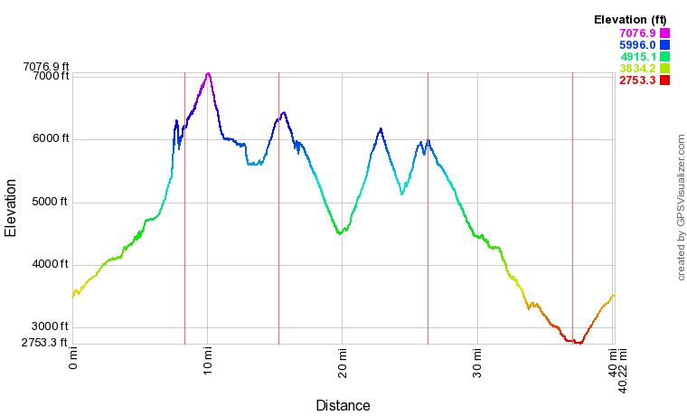
Elevation Profile
If you would like to use this info with your GPS unit, the full GPX file is here.


No comments:
Post a Comment