Monday, July 6, 2026

Washington to Florida

After living in Washington state for 17 years, we decided to move to the extreme opposite end of the country to be with Mia and Mike as they had plans to begin their family.   Further, Dad is planning on retiring after a 30-year computer engineering career.  As a rite of passage into retirement, it felt appropriate to drive across the US from Bothell, WA to Orlando, FL.  In seven days, we drove 3650 miles in 60 hours of total drive time through 12 states.  We did not have too many opportunities to get out of the car much, since we had our cat, Bella, with us, and we were worried about leaving her in the car with the hot summer temperatures we encountered throughout the trip.  Nevertheless, we visited several national parks and monuments and other interesting sites along the way. 

Badlands National Park from Burns Basin Overlook


Needles Highway as it disappears into a one-lane tunnel, Custer State Park, South Dakota

Breakdown


Date Startpoint Destination Mileage Duration
June 29th, 2026  Bothell, WA Butte, MT 621 miles 9 hrs, 7 mins
June 30th, 2026  Butte, MT Rapid City, SD 671 miles 10 hrs, 7 mins
July 1st, 2026  Rapid City, SD Rapid City, SD 220 miles 6 hrs, 15 mins
July 2nd, 2026  Rapid City, SD Omaha, NE 565 miles 8 hrs, 51 mins
July 3rd, 2026  Omaha, NE St. Louis, MO 496 miles 8 hrs, 5 mins
July 4th, 2026  St. Louis, MO Atlanta, GA 608 miles 9 hrs, 37 mins
July 5th, 2026  Atlanta, GA Orlando, FL 467 miles 8 hrs, 4 mins
TOTAL 3648 miles 60 hrs, 6 mins


Day 1: Bothell, WA to Butte, MT

We started out from Bothell around 6am on Monday morning, the day after Dad was released as bishop in the Church of Jesus Christ of Latter-day Saints. After filling up our car in North Bend, WA with the most expensive gasoline of the entire trip*, we officially bid farewell to Western Washington with a picture of Keechelus Lake. Our first true leg stretch was at Wild Horses Monument. It is the perfect place to view the Columbia River from Interstate 90. Dad even made the half-mile hike up the steep trail to the monument for an even better view. Once we left the desert of Eastern Washington, we enjoyed the scenery of the panhandle of Idaho and drove down to Coeur d'Alene Lake for a quick picture. We were especially enamored with the scenery in Western Montana, but this didn't surprise us, since Glacier National Park is one of the favorite parks we've ever visited. An indicative picture is one of several that we took as I-90 closely tracked the Clark Fork River for many miles.
On the trip, we decided to stop and get pictures of LDS temples that were along the route as well. We visited eight temples on the trip, including Moses Lake, WA and Spokane, WA on the first day. * (Gasoline in Western Washington was around $5.50 per gallon. For the other 11 states we visited, the most we paid was around $3.80.)


Day 2: Butte, MT to Rapid City, SD

As we continued across Montana, we found the scenery grew increasingly drier as evidenced by fewer trees along a landscape of rolling hills. Even though we left the Clark Fork River behind, we traveled for quite a few miles along the Yellowstone River.  I was surprised by both the size of Billings and by its picturesque setting below a lovely plateau.  The Billings Montana temple was a bit away from the interstate at the base of the plateau.

Our side trip to Devils Tower National Monument was definitely the highlight of the day.  The remains of an ancient volcanic leaves an impression, considering how it dominates in fairly unremarkable topography.  The red-rocked geology surrounding it provides plenty of photographic opportunities.


Day 3: Rapid City, SD

We stayed in Rapid City for two nights.  Leaving kitty Bella at the hotel, we ventured out for a day of exploration around the Black Hills area.  We visited Wind Cave National Park, which is among the top ten largest discovered cave systems in the world (2nd in the US).  It is known to be one of the finest examples of boxwork formation in the world.  We were treated to an array of beautiful underground structures and marbled walls on the Fairgrounds Tour

Of course, we also paid visits to Crazy Horse Monument and Mount Rushmore National Monument, but Suzanne's absolute highlight of the entire trip was driving along Needles Highway in Custer State Park.  This is not a drive for oversized vehicles!  There is a very narrow tunnel which will get your claustrophobia meter dialed up.  Calling this a one-lane tunnel is generous!  Don't believe us?  Check out the video

Our trip around the Black Hills took us over dirt roads, atop fire lookout vistas, beside lovely lake settings, to prairie dog communities.  If there was one area to explore for an extra day, we picked the right one! 


Day 4: Rapid City, SD to Omaha, NE

It didn't take us too long to get to our first stop of the day:  Wall Drug.  More of a shopping mall than a drug store (in fact, as we left, Dad told Mom that the only thing he didn't see for sell at Wall Drug were walls or drugs, she claimed that she did see medicine there), Wall Drug is a sprawling tourist destination.  We bought some donuts and a refrigerator magnet souvenir as a preview of our upcoming trip to Badlands, but we decided not to ride the wild jackelope.  

Wall, SD is the gateway to Badlands National Park.  Along with otherworldly scenery and colorful hills, we also saw bison, a rattlesnake and a mountain goat waiting for the rest of the family to come down to him.  We stopped at every pullout along Badlands Loop Road because each scene brought something different to enjoy

Once we got back on I-90, it felt like a straight shot for hours on end to cross the Missouri River and then hours more to continue to Sioux Falls, Sioux City, and eventually Omaha.  I now understand why these are called the Great Plains.

Day 5: Omaha, NE to St. Louis, MO

Before leaving Omaha, we made a stop by the Winter Quarters Nebraska temple of the church.  Behind the temple is the historic cemetery, where many LDS pioneers perished while trying to cross the plains from Illinois to the Salt Lake Valley.  Most of the headstones were either missing or so badly eroded that they couldn't be read.  Fortunately, the church has preserved the history of those who died with a monument and plaque of every individual interred there.

We were impressed by the size of the Kansas City Missouri temple and timed our arrival to Kansas City to get some legit KC Barbeque for lunch.  From there, we continued on to St Louis, Missouri where we found an awesome park with distant views of the skyline.  We also got a fun picture of the St. Louis Missouri temple with the Sun positioned to make it appear as if the Angel Moroni statue was floating above the light.

Day 6: St. Louis, MO to Atlanta, GA

To begin our Fourth of July, we decided to get a better view of the St. Louis skyline along with a view of the iconic Gateway Arch.  We were bummed that Nashville turned out to be a complete nightmare.  As we approached the city, we were met with closed roads at almost every turn because of the Independence Day Holiday.  We did get a sub-optimal picture of the Nashville skyline from a parking lot that we cropped out.  In contrast to the chaos that was downtown Nashville, we enjoyed the peace and quiet at the Nashville Tennessee Temple.

Before leaving Tennessee, we took a side trip to the Chattanooga National Military Park at Point Park.  We discovered that Chattanooga was a key Civil War battleground and enjoyed getting our first taste of a Civil War site in the Southeast.  The views of Chattanooga from the mountain were most impressive views.  A monument at the site listing those who perished in the battle was sobering.  

Day 7: Atlanta, GA to Orlando, FL

Before leaving Atlanta, we wanted to add another city skyline to our collection of photos from the trip.  We had a hard time finding a good location, but at least got something partial.   Our final temple of the trip was the Atlanta Georgia temple.  We filled up at a Buc-ees, but because it was Sunday, July 5th, the place completely overwhelmed by travelers.  Getting into and out of the property was a nightmare, and while Dad pumped gas, Mom went inside to use the restrooms, which was a bust, because the restrooms had queues that were dozens of people deep.  To say we weren't impressed with our first Buc-ees experience is an understatement.  

Photos and Videos

Dad's OneDrive album has over 200 pictures for a deeper dive that nobody asked for.


Sunday, August 10, 2025

Ross Lake Canoe Trip (2025)


Mike revisited Ross Lake for the first time since a trip with the scouts in 2013.

Because of our size, we had to obtain two backcountry camping permits, since there were six adults and ten young men. (The National Park Service allows twelve as a maximum group.) We paddled nearly 35 miles in 5 days.

 
Sunset view from the Dry Creek group campground 


The entire group ready to put in on Diablo Lake


Report


Day 1: We drove from Bothell to Colonial Creek Campground, the preeminent put-in for paddlers on Diablo/Ross lakes. Preparing all of the canoes and securing the gear took a lot of hard work. Just ask James... he knows how hard it was. Once Mike and I had our canoe tidily loaded up, we launched into the unbelievably turquoise-colored Diablo Lake. As we turned the corner to the Skagit River, we were faced with strong headwinds and deceptively choppy water. It was a bit of a grind to get to the portage dock that shuttles the canoes between Diablo and Ross Lakes. It was such a busy day that the Ross Lake Resort crew had a difficult time keeping up with all of the groups portaging between the two lakes. While waiting for hours (literally!) the boys kept themselves from overheating by diving into the river. After finishing our paddle from the Ross Lake dam to the Green Point group campground, we enjoyed a relaxing evening on the peaceful waters of the lake (even if Joss did have to swim out to free a fishing hook that was stuck in the lake.)

Day 2: Before hitting the lake, James and Anderson rigged up a sail on their canoe. Wanting in on the action, Kevin and Grayson lashed their canoe up to the sailboat to create a catamaran which remained intact for most of the journey. Once we got to Dry Creek campground, we whiled away the time swimming and playing Texas Hold 'Em. Dry Creek is on an elevated point, affording sweeping views of the lake.

Day 3: In the morning before most of the camp was awake, I took a hike along the East Bank Trail of the lake to take in the quiet morning views from the bridge on Lightning Creek. I even spotted a place to cliff jump later in the day. (No jumping from the bridge, though, kids... the national park service forbids it!) This would be one of our more memorable days, since it was a day to just tour the middle of Ross Lake with its inlets, waterfalls, and cliff jumping opportunities. The lads decided to test the catamaran as an 8-man rig, and I'm happy to report that it didn't founder.

Day 4: Without a doubt, this was our most strenuous day, not because of the mileage, but because of the strong headwinds. After a long break at Rainbow Point, we were resigned to accept our fate: we had only traveled about half of the distance we needed to cover, and unbeknownst to us, we still had the worst headwinds to deal with. It didn't stop James from putting together his best movie poster pose. Once we made it back to Green Point campground, a little hammock rest was required... at least until the rain came in, which caused everyone to scurry to their tents, where I slept like a log until dinnertime.

Day 5: Our final day of paddling started out with very calm lake conditions. It was a very short paddle past the resort to the portage dock. The portage took long enough for us to take a hike out to the dam for one last photo opportunity of the trip (minus Brian and Grant who stayed back with the canoes.) On the way back, we took a moment to explore a cave as well. Of course, no trip would be complete without stopping for food, and we all agreed that Cascade Burgers did NOT disappoint.
Final Thoughts

I think I can speak for the entire group when I say that it was an incredible trip. In fact, I enjoyed this trip so much more than the 2015 version, because it wasn't as oppressively hot this time. We also created a superior itinerary that allowed us to enjoy more of the highlights of Ross Lake without simply committing to a 50-mile milestone slog like we did on my first time on the lake.
Photos & Videos

Here is the groups' collection of photos. Everyone added their pics to this OneDrive folder, so all of the photos taken by adult leaders are there. My OneDrive album is here. There is also a YouTube playlist with a trip overview video, time lapses, and other videos to record our days on the water (paddling, cliff jumping, dock diving, etc.)
GPS Info

Here is the GPS data collected during the trip:

Maps


This Google Map is provided by GPS Visualizer

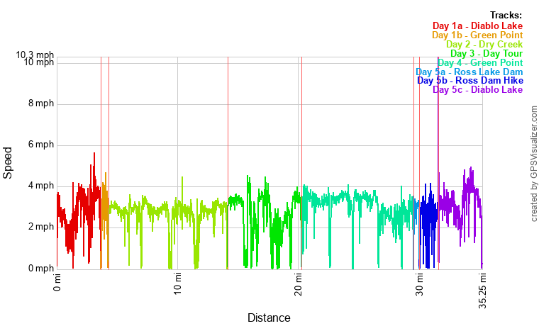
Speed Profile


Coordinates and other details:


Day One
(includes portage)
Day Two Day Three Day Four Day Five TOTAL
Mileage 4.3 miles 7.5 miles 9.1 miles 7.5 miles 9.5 miles 47.7 miles

Moving Time:

1:37:29 3:28:39 3:30:23 2:57:20 3:57:13 18:31:15

Average Moving Speed:

2.6 MPH 2.8 MPH 2.5 MPH 3.0 MPH 3.1 MPH 2.8 MPH


If you would like to use this info with your GPS unit, the full GPX file is here.
If you want to view this in Google Earth, you can download the KMZ files of the track .

Sunday, July 6, 2025

Dice Tower East

Well, this is a rarity of a vacation as far as the Lewis Family is concerned.  There is nothing outdoorsy or campish about this one.  So why did we go so off-script this year?  Well, two reasons:

  1. Living in Orlando, FL, Mia hadn't seen the family in over two years.
  2. Dad has developed an interest in board gaming, and subscribes to the Dice Tower YouTube channel.
So, why not travel from Seattle to Orlando to attend the annual Dice Tower East board game convention held at the Caribe Royale Resort?  With ~2500 games in their Florida-based library, there was definitely more than enough to keep us interested for five full days of board gaming.  

The open gaming room at the Caribe Royale the day before the convention opened


Dice Tower East photo booth with Mike, Mia, Mom, and Dad.


While there are over 2000 people who attend the convention every year, it didn't feel crowded or overwhelming.  In fact, it's an incredibly accessible and family-friendly convention, made all the better by the lovely people who run The Dice Tower.  Joey Evans was even kind enough to hop in the photo booth for a picture with Mom and Dad.  Tom Vasel, the founder of The Dice Tower, even sat down with our family for about 20 minutes to teach and help us get up and running on Race for the Galaxy.  

The convention has a brilliant flag system to connect people at the convention too.  If you need help learning a game, grab a yellow flag and someone familiar with the game will likely stop by to help teach it to you.  We grabbed a yellow flag for Everdell, and sure enough... a nice gentleman took about 15 minutes of his convention time to teach the game to us.  If you need players for a game, you can grab a green flag and set it on your table to invite others to play with you.  Maybe next year (oh, yeah... we would all go back again next year!), we will branch out more and look for green flags to meet other gamers, and learn fun games we otherwise might not have on our radar.


Games

We played the following 21 games in 5 days and ranked them from 1 to 10.  Mike missed some of the action, but still had a blast when he could be there.

Game Dad Mom Mia Mike Price
Hot Streak 7.5 8 7.5 8 $45
Meadow 9 8 9.3 9 $44
Trekking through History 8.5 7 7 7.5 $50
Ito 6.5 6 6 5 $15
Thunder Road Vendetta 10 8.5 7.1 9 $60
Everdell 8 9 9.4 9.5 $75
Canvas 6.5 6 4 $25
Forest Shuffle 9 9 9.5 $25
Bomb Busters 8.5 7.5 7.5 $35
Positano 7.5 6.5 6.5 $50
Forbidden Island 8 7.5 8 $21
A Message from the Stars 9 8 $40
Pergola 8.5 8.5 8.5 $45
Flip 7 6 6 6 $24
Splendor Marvel 7 6.5 7 $50
Race for the Galaxy 7.5 7.5 8.7 8 $36
River Valley Glassworks 9 7.5 8.1 7.5 $40
Poetry for Neanderthals 8 6 8 7 $20
Flock Together 9 9 8.5 9 $90
Things in Rings 6.5 5.5 6 5.5 $24
So Clover 7.5 7 8.7 7.5 $18

The games we played are valued at over $800, so considering that badges are $150 each for the convention, we feel like we covered the $600 in conference fees (although perhaps not the airfare for Mom and Dad.) 


Favorites

Person Game BGG Rank
Mia Forest Shuffle 174
Mike
Everdell
Race for the Galaxy
So Clover
41
87
286
Mom Everdell 41
Dad Thunder Road Vendetta 263


Photos & Videos

We did overview videos of almost every game we played... sometimes, we even showed a portion of a playthrough.  Dad also got a walkthrough video of the conference.  A YouTube playlist with all of content can be viewed here.  

Thursday, September 21, 2023

Chain Lakes Loop

On the first day of autumn, Mike was able to get in one final Saturday of good weather for a day hike to give him over 50 miles of hiking in 2023.  This was his easiest effort all year at just 6.7 miles and 2066 feet of ascent, but probably the most "bang for the buck" hike of the season in terms of scenery.  The Chain Lakes Loop is a very popular hike in the Mount Baker Wilderness of Northern Washington.  Starting from Artist Point, he did a counter-clockwise loop which addressed the most serious elevation section early in the day while his legs (and knees) were still fresh.

While the hike started with clear skies, by the time Mike got to his first view of Mt. Baker along the trail, the peak was already covered in clouds, but the view was still majestic.  

Hayes Lake along the Chain Lakes Loop in the Mount Baker Wilderness


Mount Baker and Chains Lake Basin from Herman Saddle

GPS Info

Here is the data from the GPS unit:

Maps


This Leaflet Map is provided by GPS Visualizer


Elevation Profile


This profile is provided by GPS Visualizer

Coordinates and other details


  • Mileage:
  • 6.7 Miles
  • Elevation
  • 2066 Feet
  • Time:
  • 5:08:09 (total), 3:14:21 (moving)
  • Average Speed:
  • 1.31 MPH (total), 2.07 MPH (moving)
  • Trailhead Coordinates:
  • 48°50'47.5"N 121°41'34.9"W

    The GPX file can be downloaded here.

    Photos and Videos


    Photos are available at this album.  I have also uploaded YouTube video, but the audio isn't great (there is a lot of noise... I need to figure out how to reduce noise on my GoPro.)

    Saturday, September 2, 2023

    Cascade Pass & Sahale Glacier

    Mike has a long-time friend who he hadn't seen in several years.  Out of the blue, Scott called Mike to tell him that he was on a months-long trip with his Sprinter van and would be coming through Washington state on his way back home to San Diego.  He wanted to know if Mike had recommendations on itineraries in North Cascades National Park, and if Mike would like to accompany him on a day hike.  Mike jumped at the opportunity, and offered to show off one of the premiere itineraries in the North Cascades:  Cascade Pass and the Sahale Arm.

    Throughout the week, we kept an eye out on the wildfire situation occurring in the eastern part of the national park, but as Saturday approached, the air quality looked like it would be reasonable to attempt the trip.  We were not disappointed with the views in the least.  

    The hike was a punishing 13 miles with 4500 feet of ascent that starts out deceptively mild, but the last third of the hike was a straight-up slog with steep grades.


    North Cascades from Sahale Glacier Camp


    Doubtful Lake on the Sahale Arm


    GPS Info

    Here is the data from the GPS unit:

    Maps


    This Leaflet Map is provided by GPS Visualizer


    Elevation Profile


    This profile is provided by GPS Visualizer

    Coordinates and other details


  • Mileage:
  • 13.2 Miles
  • Elevation
  • 4478 Feet
  • Time:
  • 10:05:06 (total), 6:20:07 (moving)
  • Average Speed:
  • 1.30 MPH (total), 2.08 MPH (moving)
  • Trailhead Coordinates:
  • N48° 28.550' W121° 04.538'

    The GPX file can be downloaded here.

    Photos and Videos


    Photos are available at this album.  I have also uploaded YouTube videos of Cascade Pass and the Sahale Glacier.

    Saturday, July 29, 2023

    Mason and Rainbow Lakes

    On another free Saturday at the end of July, Mike headed out for another adventure to the Alpine Lakes Wilderness to bag a couple more lakes, namely Mason Lake and Rainbow Lake.  The leisurely 5-hour day hike comprised an in-and-out hike of 10 miles with 3000 feet of ascent.  There was an abundance of hikers from the trailhead to Mason Lake, but continuing on to Rainbow Lake, there wasn't even a single hiker passed.  He peacefully enjoyed the entire lake by himself for lunch.  The temperature and weather conditions were perfect, with some wispy clouds adding perspective to the reflections in Sir Richard's Pond situated between the two lakes.


    Mason Lake

    Rainbow Lake


    Wildflowers were at their peak as well in all sorts of colors:  Red, yellow, purple, and white.  He spotted all of the following:

    • Fireweed
    • Wenatchee Paintbrush
    • Pearly Everlasting
    • Woodland Penstemon
    • Dwarf Dogwood
    • Bead Lily
    • Beargrass
    • Rosy Spiraea
    • Wandering Daisy

    GPS Info

    Here is the data from the GPS unit:

    Maps


    This Leaflet Map is provided by GPS Visualizer


    Elevation Profile


    This profile is provided by GPS Visualizer

    Coordinates and other details


  • Mileage:
  • 10.0 Miles
  • Elevation
  • 3029 Feet
  • Time:
  • 6:53:26 (total), 4:58:30 (moving)
  • Average Speed:
  • 1.45 MPH (total), 2.01 MPH (moving)
  • Trailhead Coordinates:
  • 47.42441, -121.58301

    The GPX file can be downloaded here.

    Photos and Videos


    Photos are available at this album.  I have also uploaded a YouTube video and time lapse.

    Tuesday, July 4, 2023

    Source, Snow, and Gem Lakes

    On Monday July 3rd, 2023, Mike was having one of his worst days at work since joining Microsoft nine years ago.  He had been spending weeks trying to debug a design he inherited, and progress was slow.  Working six days a week, as long as 12-14 hours a day while watching the project schedule erode was taking an emotional toll.  Monday was particularly trying for its dead-end paths, wandering in circles, and general mud stuckedness (if that's even a word.)  Adding insult to injury was the fact that it was a long weekend for most concluding with Independence Day on Tuesday, and while many were enjoying festive celebrations, Mike was having none of it because of the stress at work.  What he wanted (needed?) most was a long hike in the mountains during some epic summer weather.

    And then, a tender mercy occurred.  Around 6pm on Monday night, Mike had finally figured out the root cause for the bug he had been troubleshooting, and all tests indicated that he was definitely on the right track.  That meant that he would have an opportunity to take that hike after all.  And what better itinerary than a trip to Alpine Lakes Wilderness to bag three lakes he had never seen before: Source, Snow, and Gem Lakes.  The 13-mile hike with its 3500 feet of ascent may have been physically challenging, but it was great for the soul.

    The beauty of the area is not to be denied as evidenced by the photos and videos that he took.  Unfortunately, Mike left the SD Card for his GoPro at home, so all footage was with the cell phone, but fortunately, the area was photogenic enough to take great pictures all by itself.


    Snow Lake


    Gem Lake


    There were a handful of wildflowers captured with varying quality on Mike's cell phone.  (He really needs to figure out how to get his phone's macro mode to work better.)  With Suzanne's help, they identified the following flowers:
    • Lewis Monkeyflower
    • Fivefinger Cinquefoil
    • Thimbleberry
    • Dwarf Bramble
    • Sitka Mountain-Ash
    • Mountain Meadow-Sweet
    • Red Columbine
    • Pink Mountain Heather
    • Bear Grass
    • Pacific Bleeding Heart


    GPS Info

    Here is the data from the GPS unit:

    Maps


    This Leaflet Map is provided by GPS Visualizer


    Elevation Profile


    This profile is provided by GPS Visualizer

    Coordinates and other details


  • Mileage:
  • 12.9 Miles
  • Elevation
  • 3555 Feet
  • Time:
  • 9:17:40 (total), 6:47:38 (moving)
  • Average Speed:
  • 1.39 MPH (total), 1.90 MPH (moving)
  • Trailhead Coordinates:
  • 47.4444, -121.4231

    The GPX file can be downloaded here.

    Photos and Videos


    Photos are available at this album, while a YouTube video is available here.

    Washington to Florida

    After living in Washington state for 17 years, we decided to move to the extreme opposite end of the country to be with Mia and Mike as they...