Showing posts with label Winter. Show all posts

Friday, January 3, 2020

Skyline Lake Snowshoe

For her 22nd birthday, Mia wanted to go on a showshoe, so she and Mike drove up early in the morning to Steven's Pass and hiked into Skyline Lake.  At the lake, they noticed several people on an precarious cornice above and outcrop of rocks above the lake.  They explored the ridge leading to the summit,  and made it as far as the rock garden, where snow covered boulders were strewn across the landscape.  At this point, however, they they felt like the conditions were a little too sketchy to continue.

Here is an album of photos that show the winter wonderland we enjoyed on our hike.

Mia enjoys a panoramic view from the Skyline Lake Trail 


GPS Info

We collected all of the following data from our GPS unit during the adventure:

Maps

This Google Map is provided by GPS Visualizer

Elevation Profile


This profile is provided by GPS Visualizer

  • Mileage: 
  • Time: 
  • Average Speed: 
  • Elevation Gain:
  • Trailhead Coordinates: 
3.4 Miles
1:58:55
1.70 Miles/Hr.
1384 Feet
N47 44.859' W121 05.335'

If you would like to use this info with your GPS unit, the full GPX file is here.
If you want to view this in Google Earth, you can download the KMZ files of the track and topographic overlay.

Wednesday, February 15, 2017

Kelcema Lake Snowshoe

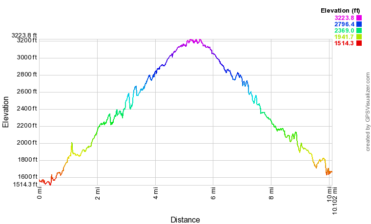
Along with three other adult leaders, we took BSA unit 655 on a snowshoe trip to Kelcema Lake along the Mountain Loop Highway.  With the exception of a couple of young men, very few of the twelve boys who came along had ever snowshoed before.  We had a great day enjoying the beautiful scenery, even though it was a more rigiorous adventure than most were expecting.  Originally, we had planned on hiking to the Big Four Ice Caves, which would have been an easier itinerary, but that hike was closed due to avalanche danger, so rather than hike along the road which didn't really need any snowshoes at all, we decided to hike along Deer Creek Road (NF-1042).  With 1700 feet of  elevation gain, we definitely found enough snow to strap on the showshoes.  The 10 mile round-trip hike took six hours to complete, but it didn't feel that long (although some of the scouts might debate that.)  


When we started out, I told our scouts that we had 4.5 miles to reach the lake, but that we would hike for 2.5 hours and then turn around if we couldn't make it all the way in that period of time.  We were at the 2.5 hour mark when the entire group had caught up to an icicle-laden rock wall that the boys were having fun with.  I told them that we still had about a mile to get to the lake, and that we could turn back as promised.  I asked who wanted to continue on to the lake, and nearly every one of them pressed forward!  I was proud of these young men for their determination to press on to their final goal even though it was hard work.

Photos of the boys and the scenery are posted online here.


Scout leader, Adam Robinson, stands above the Kelcema Lake trailhead sign, indicating the snow depth.


GPS Info

We collected all of the following data from our GPS unit during the adventure:

Maps


This Google Map is provided by GPS Visualizer

Elevation Profile


This profile is provided by GPS Visualizer

Coordinates and other details

  • Mileage: 
  • Time: 
  • Average Speed: 
  • Elevation Gain:
  • Trailhead Coordinates: 
9.8 Miles
5:41:39
1.73 Miles/Hr.
1710 Feet
N48 05.092' W121 33.144'


If you would like to use this info with your GPS unit, the full GPX file is here.
If you want to view this in Google Earth, you can download the KMZ files of the track and topographic overlay.

Friday, December 28, 2012

Hatchery Creek Snowshoe

While on a winter break trip to Lake Wenatchee and Leavenworth, we explored a snowshoe trail along Hatchery Creek just off of US Route 2.  During the trip, Raymond lost one of the snow baskets from his trekking poles, making it a bit difficult for him to maneuver with just one pole that didn't sink into the snow.  We were hoping to get to a small pond to see if it was frozen over, but we were running low on daylight (and energy!) so we didn't make it there, but we still had a great time exploring the peaceful winter wonderland.


GPS Info

We collected all of the following data from our GPS unit during the adventure:

Maps


This Google Map  is provided by GPS Visualizer

Elevation Profile


This profile is provided by GPS Visualizer

Coordinates and other details

  • Mileage: 
  • Time: 
  • Average Speed: 
  • Trailhead Coordinates: 
1.4 Miles
01:45
1.9 Miles/Hr.
N47° 40.694', W120° 44.085'


Leavenworth Tubing

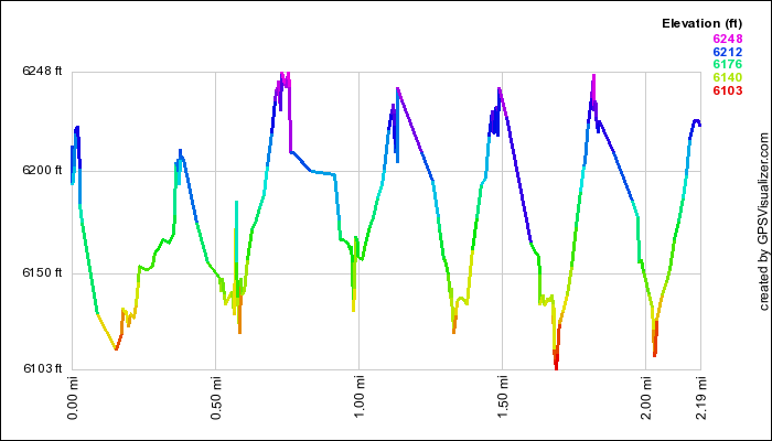
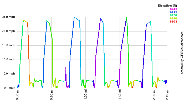
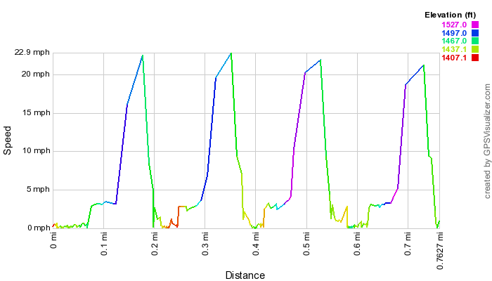
During the winter break, we took a trip to Lake Wenatchee to spend a couple of days in the snow.  Our family friend, Dale Partna, was nice enough to let us stay in his cabin for two nights after Christmas and we had a blast in the snow.  On one outing, we checked out the tubing hill at the Leavenworth Winter Sports Club.  It was about 30 degrees, but we bundled ourselves up and enjoyed the outing--at least until Suzanne bruised her bottom as she bounced too hard in the tube during one run, and the kids started complaining about headaches.   While we didn't take any pictures, we did want to show our GPS data that shows the drop and speed of the run, coming down the 500-foot long hill that drops about 100 feet to the bottom.  It wasn't as much fun as the tubing hill at Bogus Basin, but it was still enjoyable.   


GPS Info

We collected all of the following data from our GPS unit during the adventure:

Maps


This Google Map  is provided by GPS Visualizer

Elevation Profile


This profile is provided by GPS Visualizer

Speed Profile


This profile is provided by GPS Visualizer

Coordinates and other details

  • Mileage: 
  • Time: 
  • Tubing Speed: 
  • Trailhead Coordinates: 

0.8 Miles
00:52\
23 Miles/Hr.
N47° 36.807, W120° 40.107


If you would like to use this info with your GPS unit, the full GPX file is here.
If you want to view this in Google Earth, you can download the KMZ files of the track  and topographic overlay.
Wenatchee Showshoe

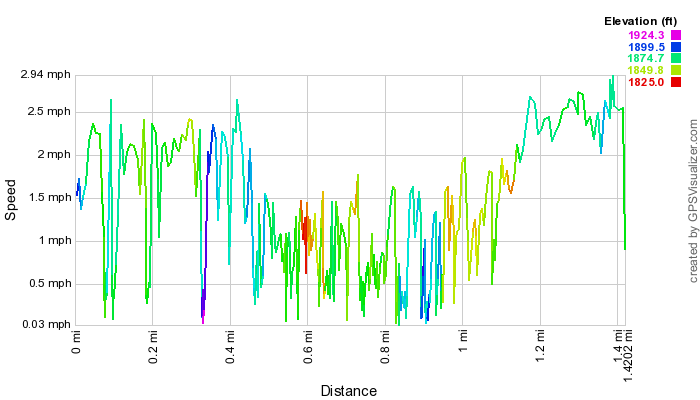
During the winter break, we took a trip to Lake Wenatchee to spend a couple of days in the snow.  Our family friend, Dale Partna, was nice enough to let us stay in his cabin for two nights after Christmas and we had a blast in the snow.  One afternoon, Mia and I went scouting on snowshoes to find the Wenatchee River from Dale's cabin.  On a previous visit, Dale took us on snowmobiles to a spot along the river, but Mia and I are pretty sure that we didn't follow the same path, based on the fact that we did some serious cross-country snowshoeing, including a couple of episodes with tree wells.  Fortunately, we had each other to help out of the wells, and the snow was only a few feet deep, so we never got into any truly sticky situations.  You can see from the speed profile below, where we got bogged down going across country, while towards the end, we got so comfortable in the snowshoes and terrain that we practically raced back to the cabin.


GPS Info

We collected all of the following data from our GPS unit during the adventure:

Maps


This Google Map  is provided by GPS Visualizer

Speed Profile

This profile is provided by GPS Visualizer

Coordinates and other details

  • Mileage: 
  • Time: 
  • Average Speed: 
  • Trailhead Coordinates: 
1.4 Miles
01:22
1.0 Miles/Hr.
+47° 47' 28.74", -120° 38' 59.88"

 
If you would like to use this info with your GPS unit, the full GPX file is here.
If you want to view this in Google Earth, you can download the KMZ files of the track  and topographic overlay.

Sunday, February 17, 2008

Hoodoo Showshoe

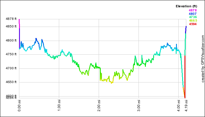
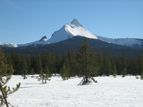
On our get-away to Oregon's Central Cascades, we took a snowshoe trip near Hoodoo Ski Resort.  The snow was very icy, so we didn't have to worry about sinking into powder.  We had magnificient views of a couple of peaks in the Cascades, as well a couple  of  downhill skiiers coming down the very steep backside of Hayrick Butte.  The run drops an average of one foot of vertical distance for every two feet of horizontal distance.  At the top, the angle is about 45 degrees!  If you look closely enough, you can see the ski tracks here.  You can see the full set of pictures from the outing here.

Mt. Washington from meadow on South Loop at Ray Benson Sno Park.


GPS Info

We collected all of the following data from our GPS unit during the adventure:

Maps


This Google Map is provided by GPS Visualizer

Elevation Profile


This profile is provided by GPS Visualizer

Coordinates and other details

  • Mileage: 
  • Time: 
  • Average Speed: 
  • Trailhead Coordinates: 
4.2 Miles
02:25
2 Miles/Hr.
N44 24.281 W121 51.723


If you would like to use this info with your GPS unit, the full GPX file is here.
If you want to view this in Google Earth, you can download the KMZ files of the track and topographic overlay.
Sunday, January 13, 2008

Bogus Basin Tubing

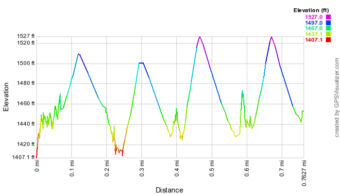
During the winter break, Mike took Amelia & Raymond to the tubing hill at Bogus Basin Ski Resort.  While it was about 37 degrees , the wind was blasting snow in our faces at about 25 miles per hour.  We could only handle the biting cold for an hour and a half of our two-hour session on the hill.  The kids had a blast anyway, and I'm sure we'll be heading back up there.  While we didn't take any pictures, we did want to show our GPS data that indicates tube speeds of up to 25 MPH, coming down the 800-foot long hill.


GPS Info

We collected all of the following data from our GPS unit during the adventure:

Maps


This Google Map is provided by GPS Visualizer

Elevation Profile


This profile is provided by GPS Visualizer

Speed Profile


This profile is provide by GPS Visualizer

Coordinates and other details

  • Mileage: 
  • Time: 
  • Average Speed: 
  • Trailhead Coordinates: 
0.6 Miles
00:28
1.3 Miles/Hr.
N 43° 41 52.26, W 116° 6 31.74

 
If you would like to use this info with your GPS unit, the full GPX file is here.
If you want to view this in Google Earth, you can download the KMZ files of the track and topographic overlay.
Monday, December 31, 2007

Pilgrim Loop Showshoe

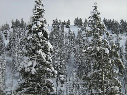
During the winter break, Mike took Amelia & Raymond snowshoeing near Idaho City.  They found a nice loop trail that wandered peacefully through the snow-covered forest.  Mike enjoyed the fresh air and snow.  The kids enjoyed getting back to the car--and a thermos of hot apple cider--as it was about 20 degrees outside that day.


Snow-covered trees in the Boise National Forest.


GPS Info

We collected all of the following data from our GPS unit during the adventure:

Maps


This Google Map is provided by GPS Visualizer

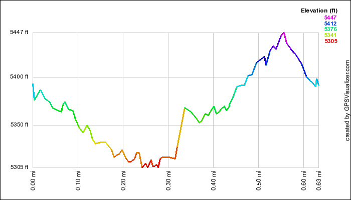
Elevation Profile


This profile is provided by GPS Visualizer

Coordinates and other details

  • Mileage: 
  • Time: 
  • Average Speed: 
  • Trailhead Coordinates: 
0.6 Miles
00:28
1.3 Miles/Hr.
N 43º 57.747  W 115º 37.698


If you would like to use this info with your GPS unit, the full GPX file is here.
If you want to view this in Google Earth, you can download the KMZ files of the track and topographic overlay.
Saturday, December 29, 2007

Lucky Peak Snowshoe

During the winter break, Mike took Amelia & Raymond snowshoeing near Idaho City.  They found a nice loop trail that wandered through the snow-covered forest.  Fortunately, it was a short trip, because both of the kids complained about getting cold--it was about 20 degrees


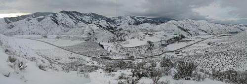
A seven-frame panorama from the ridge on the hike.  The turnout on the road in the middle of the picture is where this adventure started.  (Click on the picture to see it in full size.)


GPS Info

Mike collected all of the following data from our GPS unit during the adventure:

Maps


This Google Map is provided by GPS Visualizer

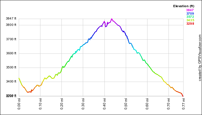
Elevation Profile

This profile is provided by GPS Visualizer

Coordinates and other details

  • Mileage: 
  • Time: 
  • Average Speed: 
  • Campsite/Trailhead Coordinates: 
0.8 Miles
1:22
0.6 Miles/Hr.
N 43º 37.608  W 115º 59.278


If you would like to use this info with your GPS unit, the full GPX file is here.
If you want to view this in Google Earth, you can download the KMZ files of the track and topographic overlay.
Washington to Florida

After living in Washington state for 17 years, we decided to move to the extreme opposite end of the country to be with Mia and Mike as they...