Mike revisited Ross Lake for the first time since a trip with the scouts in 2013.
Because of our size, we had to obtain two backcountry camping permits, since there were six adults and ten young men. (The National Park Service allows twelve as a maximum group.) We paddled nearly 35 miles in 5 days.
 Sunset view from the Dry Creek group campground
The entire group ready to put in on Diablo Lake
Report
Day 1: We drove from Bothell to Colonial Creek Campground, the preeminent put-in for paddlers on Diablo/Ross lakes. Preparing all of the canoes and securing the gear took a lot of hard work. Just ask James... he knows how hard it was. Once Mike and I had our canoe tidily loaded up, we launched into the unbelievably turquoise-colored Diablo Lake. As we turned the corner to the Skagit River, we were faced with strong headwinds and deceptively choppy water. It was a bit of a grind to get to the portage dock that shuttles the canoes between Diablo and Ross Lakes. It was such a busy day that the Ross Lake Resort crew had a difficult time keeping up with all of the groups portaging between the two lakes. While waiting for hours (literally!) the boys kept themselves from overheating by diving into the river. After finishing our paddle from the Ross Lake dam to the Green Point group campground, we enjoyed a relaxing evening on the peaceful waters of the lake (even if Joss did have to swim out to free a fishing hook that was stuck in the lake.)
Day 2: Before hitting the lake, James and Anderson rigged up a sail on their canoe. Wanting in on the action, Kevin and Grayson lashed their canoe up to the sailboat to create a catamaran which remained intact for most of the journey. Once we got to Dry Creek campground, we whiled away the time swimming and playing Texas Hold 'Em. Dry Creek is on an elevated point, affording sweeping views of the lake.
Day 3: In the morning before most of the camp was awake, I took a hike along the East Bank Trail of the lake to take in the quiet morning views from the bridge on Lightning Creek. I even spotted a place to cliff jump later in the day. (No jumping from the bridge, though, kids... the national park service forbids it!) This would be one of our more memorable days, since it was a day to just tour the middle of Ross Lake with its inlets, waterfalls, and cliff jumping opportunities. The lads decided to test the catamaran as an 8-man rig, and I'm happy to report that it didn't founder.
Day 4: Without a doubt, this was our most strenuous day, not because of the mileage, but because of the strong headwinds. After a long break at Rainbow Point, we were resigned to accept our fate: we had only traveled about half of the distance we needed to cover, and unbeknownst to us, we still had the worst headwinds to deal with. It didn't stop James from putting together his best movie poster pose. Once we made it back to Green Point campground, a little hammock rest was required... at least until the rain came in, which caused everyone to scurry to their tents, where I slept like a log until dinnertime.
Day 5: Our final day of paddling started out with very calm lake conditions. It was a very short paddle past the resort to the portage dock. The portage took long enough for us to take a hike out to the dam for one last photo opportunity of the trip (minus Brian and Grant who stayed back with the canoes.) On the way back, we took a moment to explore a cave as well. Of course, no trip would be complete without stopping for food, and we all agreed that Cascade Burgers did NOT disappoint.
Final Thoughts
I think I can speak for the entire group when I say that it was an incredible trip. In fact, I enjoyed this trip so much more than the 2015 version, because it wasn't as oppressively hot this time. We also created a superior itinerary that allowed us to enjoy more of the highlights of Ross Lake without simply committing to a 50-mile milestone slog like we did on my first time on the lake.
Photos & Videos
Here is the groups' collection of photos. Everyone added their pics to this OneDrive folder, so all of the photos taken by adult leaders are there. My OneDrive album is here. There is also a YouTube playlist with a trip overview video, time lapses, and other videos to record our days on the water (paddling, cliff jumping, dock diving, etc.)
GPS Info
Here is the GPS data collected during the trip:
Maps
This Google Map is provided by GPS Visualizer
Speed Profile
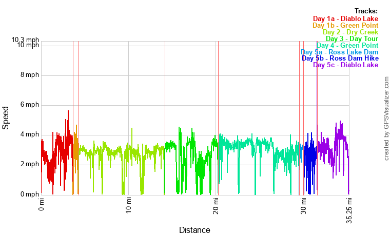
Coordinates and other details:
|
|
Day One (includes portage) |
Day Two | Day Three | Day Four | Day Five | TOTAL |
| Mileage | 4.3 miles | 7.5 miles | 9.1 miles | 7.5 miles | 9.5 miles | 47.7 miles |
|
Moving Time: |
1:37:29 | 3:28:39 | 3:30:23 | 2:57:20 | 3:57:13 | 18:31:15 |
|
Average Moving Speed: |
2.6 MPH | 2.8 MPH | 2.5 MPH | 3.0 MPH | 3.1 MPH | 2.8 MPH |
If you would like to use this info with your GPS unit, the full GPX file is here.
If you want to view this in Google Earth, you can download the KMZ files of the track .


No comments:
Post a Comment