Ahead of their 27th wedding anniversary, Suzanne and Mike took a trip to Sucia Island State Park, a member of the San Juan Islands in the Strait of Georgia. Because there is no state ferry service to Sucia Island, most visit the island by private boat. Because they don't have a boat, Mike and Suzanne got to their campground with a bit more logistical preparation that required them to:
- Drive from their home to Anacortes, WA
- Board the ferry from Anacortes to Orcas Island
- Drive to Eastsound, WA on the north side of Orcas.
- Board a water taxi to Sucia Island
- Backpack their camping gear from Fossil Bay to North Echo Bay
- Hike back to Fossil Bay to prepare the kayak
- Paddle from Fossil Bay to Mud Bay
- Portage across the spit from Mud Bay to Snoring Bay
- Paddle from Snoring Bay to campsite at North Echo Bay via South Finger and Justice Islands
They left home at 5am and were finally
set up at camp with their kayak on shore at 3:15pm.
Sucia is a beautiful island chocked full of gravelly beaches, hidden coves, large bays, intricate rock formations, forested paths, bluffs with expansive vistas, tranquil sunsets, and thrilling wildlife. They saw otters, seals, herons, gulls, cormorants, eagles (along with a ridiculously large nest,) bats, snakes, lizards, mice (keep your food very secure on Sucia!), and naturally, plenty of ants and mosquitoes.
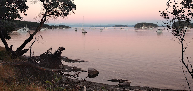
Dusk on Fossil Bay with Mount Baker in the background
Activities
The focus of this itinerary was threefold:
kayaking,
hiking, and
relaxing. Hiking would typically happen in the morning, with kayaking in the afternoon, and relaxing in the evenings, watching the
sunset and enjoying the
view from the campsite. They collected the following details from their GPS:
| Activity | Distance (miles) |
Elev. Gain
(ft)
|
| Backpacking |
2.7 |
550 |
| Hiking |
16.2 |
2420 |
| Kayaking |
8.7 |
-- |
| TOTALS |
27.6 |
2970 |
Map
The following are the maps of hiking and paddling along with a
GPX file with all of these hikes. The maps and profiles are all produced by
GPS Visualizer.
Hiking
Kayaking
Profiles
Hiking Elevation
Kayaking Speed
For a remote island accessible by boat only, the
Washington State Parks service does a great job at maintaining the facilities. The compost toilets were always clean, and the campsites well maintained. The staff were occasionally spotted on their John Deere tractor, and they were all very friendly. When they saw pedestrians on the trail, they would come to a complete stop until passed to keep dust off of visitors.
Favorites
- Mike: Enjoying the expansive scenery of the Georgia Strait, with boats, otters, seals, and birds enjoying the waters during sunset.
- Suzanne: Exploring the rocky coastline via kayak.
Lowlights
The biggest misfortune on the trip was Suzanne's fall that injured her right elbow. Because she was no longer able to paddle, they had to limit their kayaking distance, since Mike had to do all of the paddling. As a result, they weren't able to explore some of the areas they had hoped to.
The mosquitos were annoying as well. The bug spray did a reasonable job of keeping them from attacking, but both were bitten several times.
Photos
There are
160 photos and a
video of one kayak outing, which traversed Fossil Bay, Shallow Bay, and Fox Cove. Click the links to view them all.


No comments:
Post a Comment