Saturday, July 4, 2020

Sammamish River Kayaking (Mike & Raymond)

 To enjoy the beautiful Independence day holiday, Mike and Raymond took the kayak out for a spin on the Sammamish River in Bothell.  With all of the people walking the Sammamish River Trail, we agreed that a float on the river was the best way to socially distance during COVID-19.

Raymond paddles through the Sammamish River in Kenmore, WA


GPS Info

We collected all of the following data from our GPS unit during the adventure:

Maps

This Google Map is provided by GPS Visualizer

Speed Profile


• Mileage: 4.2 mi
• Time: 1:35:50
• Speed: 2.7 MPH
• Trailhead Coordinates: N47 45.539', W122 12.265'


Thursday, April 16, 2020

Sammamish River Kayaking (Mike & Mia)

Before Mia left for her summer job in Wisconsin at the Chequamegon-Nicolet National Forest, she and Mike took the kayak for a paddle on the Sammamish River in Bothell for a socially-distanced activity during the peak of closures during COVID-19. Since parks were closed, we felt that the best place to put in was at Brackett's Landing, which has river access, but public street parking as well.  The trees were in peak blossom as we cruised along the river.  We even saw an otter at the end of our trip, which we didn't get a chance to photograph, because it dipped back into the water too quickly.

Mia enjoys the reflection of the pedestrian bridge at Bothell Landing just months before its demolition made way for a new bridge.


GPS Info

We collected all of the following data from our GPS unit during the adventure:

Maps

This Google Map is provided by GPS Visualizer

Speed Profile


This profile is provided by GPS Visualizer

• Mileage: 2.3 mi
• Time: 1:31:27
• Speed: 2.5 MPH
• Trailhead Coordinates: N47 45.279', W122 11.658'

Thursday, February 20, 2020

Southern Exposure RV Trip

The year 2020 will be remembered for many bad things: the COVID-19 pandemic, toilet paper shortages, police brutality, and Black Lives Matter to name a few.  But before everything went askew in the world, we were able to take an unprecedented family vacation in February.  The reason for this early vacation was because Mia was going to be heading off to Wisconsin in March to begin a contract position with the Nicolet-Chequamegon National Forest.

Because this was a splurge year, we flew to Phoenix, Arizona and rented an RV on Outdoorsy to explore the Southwest.  This was our first time in an RV and also our first time visiting this part of the country.  Along the way, we visited five national parks and two national monuments in Arizona, New Mexico, and Texas.  This trip brings our national park tally to 31, which is over half of the parks in the National Park Service.

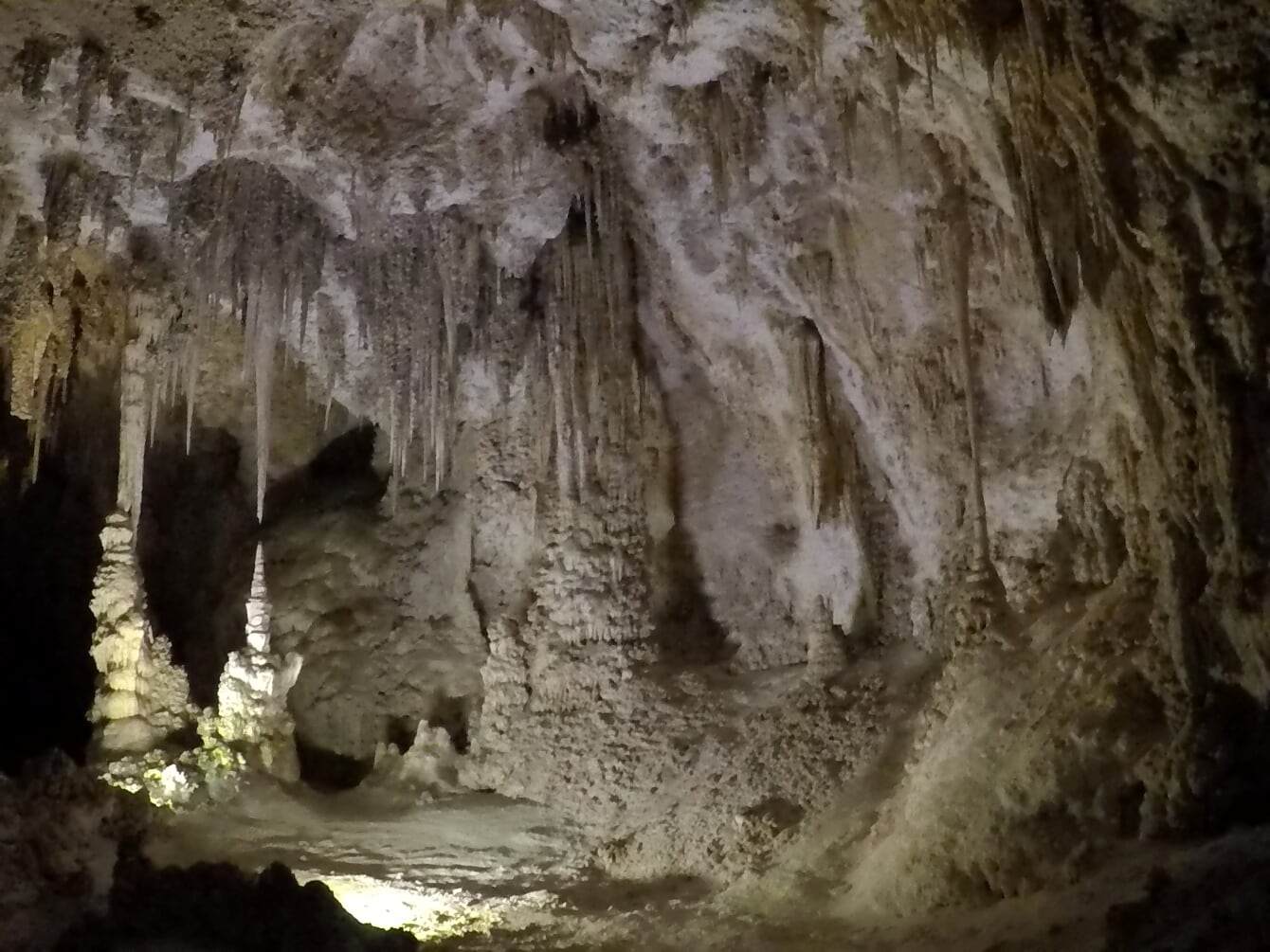
Carlbad Caverns National Park was everybody's number one highlight

Driving

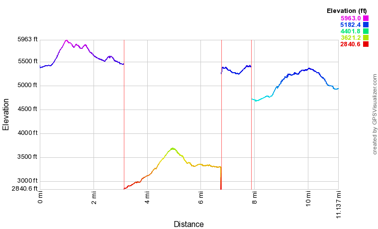
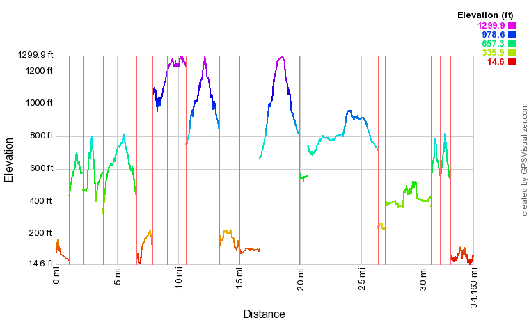
The Southwest of the United States is big.  Actually, it's ginormous.  We just couldn't believe how many hours of driving it took to pretty much get anywhere in Texas.  In a little over a week, we put over 2000 miles onto the RV, averaging about 250 miles per day.  The following map is a sketch of our travels:


Hiking

Along with the 2000 miles of driving, we added about 30 miles of hiking (Carlsbad Caverns National Park isn't tallied in our total mileage, because GPS doesn't work underground.)  The map below has location prefixes as follows:


Here is a list of every hike we took in chronological order and a GPX file with all of these hikes 

Hike

Distance (miles)

Approx. Elev. Gain (ft)

SNP: King Canyon Trail2.0506
SNP: Mica View Trail1.474
CNM: Echo Canyon Trail3.4614
BBNP: Santa Elena Canyon Trail1.8561
BBNP: Tuff Canyon Trail1.1135
BBNP: Lower Buffo Mesa Pouroff1.2109
BBNP: Sam Nail Ranch0.437
BBNP: Boquillas Canyon Trail1.4169
GMNP: Pinery Butterfield Stage Station Ruins1.2292
GMNP: McKitrick Nature Trail1.1224
GMNP: Frijole Ranch / Smith Spring Trail2.7485
LNF: Osha Trail0.6187
WSNP: Playa Trail0.4194
WSNP: Interdune Boardwalk0.526
WSNP: Dune Life Nature Trail1.4120
WSPN: Alkali Flat Trail1.056
TNF: Tonto Lower Cliff Dwelling1.7468
TNF: Cemetery / Thompson Trail2.3456
TNF: Windy Hill Walk1.5103
TOTALS27.34814

Highlights   

After visiting 7 National Parks and Monuments, here is how we ranked them all.  Amelia appeared to have the most representative ranking, as her list most closely matched the average ranking of each park.  Her only miss was swapping the two bottom ranked parks.  Raymond also swapped two parks compared to average ranking, but they were the #3 and #6 parks, oddly enough.  He ranked Guadalupe higher because he really enjoyed seeing the old Frijole Ranch and liked the setting of the Smith Spring Trail.

Order Park Mike Suzanne Amelia Raymond Average
5 Carlsbad Caverns NP 1 1 1 1 1
2 Chiricahua NM 3 2 2 2 2.25
3 Big Bend NP 2 3 3 6 3.5
7 Tonto NM 5 4 4 4 4.25
6 White Sands NP 4 7 5 5 5.25
4 Guadalupe NP 7 6 7 3 5.75
1 Saguaro NP 6 5 6 7 6

We didn't expect to see as much wildlife in the desert Southwest as we did.  Here is a list of what we spotted on our trip:
  • Lots of deer
  • Herd of bighorn sheep
  • 2 bobcats
  • 2 wild horses
  • 2 vultures
  • 2 acorn woodpeckers
  • 1 wild burro
  • 1 roadrunner
  • 1 coatimundi
  • 1 chipmunk
  • 1 turtle
  • 1 rabbit
  • 1 lizard
  • 1 wild boar (javelina) 
  • coyotes (heard, but not seen

Photos

Here is a photo album of nearly 1000 pictures that Mike took with his phone during the trip.  There are also a handful of GoPro pictures and videos here, including videos and time lapse images of our driving and sledding (yes, sledding!) in White Sands National Park.


Friday, January 3, 2020

Skyline Lake Snowshoe

For her 22nd birthday, Mia wanted to go on a showshoe, so she and Mike drove up early in the morning to Steven's Pass and hiked into Skyline Lake.  At the lake, they noticed several people on an precarious cornice above and outcrop of rocks above the lake.  They explored the ridge leading to the summit,  and made it as far as the rock garden, where snow covered boulders were strewn across the landscape.  At this point, however, they they felt like the conditions were a little too sketchy to continue.

Here is an album of photos that show the winter wonderland we enjoyed on our hike.

Mia enjoys a panoramic view from the Skyline Lake Trail 


GPS Info

We collected all of the following data from our GPS unit during the adventure:

Maps

This Google Map is provided by GPS Visualizer

Elevation Profile


This profile is provided by GPS Visualizer

  • Mileage: 
  • Time: 
  • Average Speed: 
  • Elevation Gain:
  • Trailhead Coordinates: 
3.4 Miles
1:58:55
1.70 Miles/Hr.
1384 Feet
N47 44.859' W121 05.335'

If you would like to use this info with your GPS unit, the full GPX file is here.
If you want to view this in Google Earth, you can download the KMZ files of the track and topographic overlay.

Friday, August 30, 2019

Mount Rainier National Park

While driving around the Puget Sound area on a clear day, it is hard to miss the iconic view that is Mount Rainier.  At over 14,400 feet in elevation, it is the largest mountain in the state of Washington.  It is also considered one of the most dangerous volcanoes in the world because it is due for an eruption at any time, and is close to a huge population center.  

Unbothered by its potential for violence, we were excited to visit Mt. Rainier National Park for the first time in 10 years, especially because we were anticipating getting to see the mountain from the Eastern side of the mountain known as the Sunrise Area.  However, this turned out to be our shortest vacation ever, as a knee injury kept Raymond from being able to continue to camp and hike.  But, that didn't stop us from taking over 100 pictures in a couple of days.

Iconic setting of Mount Rainier with Reflection Lake in foreground

Hiking

Because the trip was so short, we were only able to take four hikes:

Hike

Approx. Elev. Gain (ft)

Distance (miles)

Alta Vista / Deadhorse Creek / Waterfall Trails8493.1
Carter / Madcap Falls11113.6
Nisqually Vista Trail3471.1
Reflection Lake / High Lakes Trail7883.2
TOTALS309511.1


GPS Info


Here is a link to our GPX file 


Maps


This Map is provided by GPS Visualizer

Elevation Profile

This Map is provided by GPS Visualizer

Photos

While our trip was significantly short, it still didn't stop us from taking nearly 100 pictures of the photogenic park.


Thursday, August 30, 2018

Sunshine Coast


I often hear recreational fishermen say, "A bad day of fishing is better than a good day at work."  This is usually said to downplay the disappointment of not catching any fish.  In that spirit, we had a few "bad days" of vacation followed by a few great days of vacation.  The trip started incredibly smoky (due to all of the wildfires in British Columbia and Washington State)... so much so that we couldn't enjoy any of the beautiful views that the Sunshine Coast affords.  But in the middle of our trip we woke up one day to beautiful clear conditions and were treated to amazing views.    

The Sunshine Coast lies along the Strait of Georgia in British Columbia, Canada.  Part of the fun of the Sunshine Coast is getting there... crossing the border, driving through Vancouver, and then taking two ferry rides across beautiful inlets to get to the north side of the coast.   While there are two halves to the Sunshine Coast separated by the second ferry, we stayed in the North half and spent most of our time up there, where it is more isolated, rugged, remote, and quiet.   

One of the many views on Inland Lake.

Hiking

We hiked over 34 miles in six days.  Even though these were largely low-elevation coastal hikes, the GPS claimed that we still climbed around 6400 feet.  As a point of comparison, my Fitbit Blaze conveyed an elevation gain of about 7000 feet, but that includes ALL daily activity (including non-hiking activity, where the GPS isn't necessarily turned on.). 

Here are the details on our individual hikes:

Hike

Approx. Elev. Gain (ft)

Distance (miles)

Soames Hill5651.6
Burnett Falls1251.1
Hidden Grove3001.2
Dinner Rock Park2351.3
Atrevida Loop5502.8
Gibralter Lookout3401.2
Rieveley's Pond2101.5
Powell River Historic District2251.7
Willingdon Trail1501.6
Appleton Creek7102.7
Haslam Lake350.7
Black Water Creek7303.2
Mud Lake / Suicide Creek4905.8
Valentine Mountain4250.8
Haywire Bay500.6
Inland Lake / Lost Lake3903.7
Valentine Mountain (Sunset)2600.8
Francis Point Provincial Park3751.9
TOTALS613534.2

GPS Info


Here is a link to our GPX file and KMZ file for Google Earth.  

Maps


This Map is provided by GPS Visualizer

Elevation Profile

We experienced a mix of hiking along the coast (colored red and yellow in the plot below, since these are near sea level), level forest hikes, and steeper climbs to great viewpoints.

 
This profile is provided by GPS Visualizer

Highlights

  • Wildlife.  We didn't see much big game, excepting for a deer or two.  But we did see lots of frogs, toads, and garter snakes.  We also saw a couple of seals interacting (were they playing?  fighting???) from the ferry.
  • Solitude.  The north end of the Sunshine Coast seems fairly populated.  Powell River has a population of over 13,000 people.  However, the land mass and network of trails is wide enough to experience nature all to one's self.  In fact, while some of the hikes on our list were fairly populated, about half of them were not.  In about 20 miles of our hiking, we counted a total of just five hikers and two mountain bikers.  That's an average of one human seen every three miles of hiking!
  • Marvelous weather.   We enjoyed temperatures in the 70s during the day, and in the 50s at night.  Temperatures nudged downward slightly throughout the week, but it was only towards the end that I even had to zip my sleeping bag up all the way.  Otherwise, the weather was great for hiking during the day and sleeping during the night.
  • At one point, Suzanne wondered whether some of the inlets we experienced would be like the fjords of Norway (one of our bucket list items.)  Apparently, we don't have to travel as far as we thought to see such majestic coastlines!
  • The Sunshine Coast Trail is a 110-mile long backcountry hut-to-hut trail that would make for an incredible backpacking itinerary.  We hiked to the hut at Rieveley's pond and were amazed at its size and amenities for being so far away from civilization.

Lowlights

  • Smoke.  How bad was it?  This bad.
  • The hornets were quite agressive.  We constantly had to shoo them away from our campsite or kill them outright.  On one trail, we had five stings (Raymond=2, Mike=2, Suzanne=1).
  • The logistics for seeing all of the Sunshine Coast is difficult because of the expensive and time-consuming ferry ride across the Jervis Inlet.  The round trip ferry from Earl's Cove to Saltery Bay that seperates the north and south sections of the coast only runs a few times a day and was over $100 for one vehicle and five passengers, so it didn't make sense to go back and forth.  As such, we decided to explore as much of the southern coast on the drive up and back.  Perhaps we should return to explore the southern coast in more depth later.

Favorites

Here's what each family member said was their favorite part of the trip:

Raymond:Hidden GroveIntricate network of trails winding through massive trees in an old growth forest
Amelia:

Suicide Creek

Trail through forest of aspens, pines, and madronas with an amazing viewpoint from a logging clear cut site.
Chris:Soames HillAmazing trail network with hundreds of stair steps leading to the summit
Suzanne:Inland Lake CampgroundSet in a forest of cedar, maples, and madronas along the shore of a picturesque lake whose charm changed multiple times with various lighting and weather conditions
Mike:Appleton Creek

Several quaint waterfalls along a rocky creek bed.

Photos

You can take a look at all of our pictures here.  There are also some videos and time lapses taken from my GoPro on this YouTube playlist.

Wednesday, August 29, 2018

Ashland Lakes Backpack

A few friends decided to do an end-of-season backpack trip to Ashland Lakes along the Mountain Look Highway in the North Cascades.  While it was gray and rainy, and we got quite soggy on our hike out, we enjoyed great company and views of three alpine lakes (Lower Ashland, Upper Ashland, and Beaver Plant.)  The real discovery for me was that this would be a great place to take younger scouts backpacking.  It was a relatively short hike with little elevation gain that takes the hiker by three small, but pretty lakes.  There were a couple of great spots for group camping as well along with pit toilets at each lake.  


I didn't get many pictures, because the weather was not very cooperative, but here are a few that I did take.


Lower Ashland Lake, near campsite  


GPS Info

We collected all of the following data from our GPS unit during the adventure:

Maps


This Google Map is provided by GPS Visualizer

Elevation Profile

This profile is provided by GPS Visualizer

Coordinates and other details

  • Mileage: 
  • Time: 
  • Average Speed: 
  • Trailhead Coordinates: 
12.1 Miles
6:13:55 (moving)
1.94 MPH (moving)
N47 36.519' W121 23.163'


If you would like to use this info with your GPS unit, the full GPX file is here.
If you want to view this in Google Earth, you can download the KMZ files of the track and topographic overlay.

Dice Tower East

Well, this is a rarity of a vacation as far as the Lewis Family is concerned.  There is nothing outdoorsy or campish about this one.  So why...