I often hear recreational fishermen say, "A bad day of fishing is better than a good day at work." This is usually said to downplay the disappointment of not catching any fish. In that spirit, we had a few "bad days" of vacation followed by a few great days of vacation. The trip started incredibly smoky (due to all of the wildfires in British Columbia and Washington State)... so much so that we couldn't enjoy any of the beautiful views that the Sunshine Coast affords. But in the middle of our trip we woke up one day to beautiful clear conditions and were treated to amazing views.
The Sunshine Coast lies along the Strait of Georgia in British Columbia, Canada. Part of the fun of the Sunshine Coast is getting there... crossing the border, driving through Vancouver, and then taking two ferry rides across beautiful inlets to get to the north side of the coast. While there are two halves to the Sunshine Coast separated by the second ferry, we stayed in the North half and spent most of our time up there, where it is more isolated, rugged, remote, and quiet.

One of the many views on Inland Lake.
Hiking
We hiked over 34 miles in six days. Even though these were largely low-elevation coastal hikes, the GPS claimed that we still climbed around 6400 feet. As a point of comparison, my Fitbit Blaze conveyed an elevation gain of about 7000 feet, but that includes ALL daily activity (including non-hiking activity, where the GPS isn't necessarily turned on.).
Here are the details on our individual hikes:
| Hike | Approx. Elev. Gain (ft) | Distance (miles) |
| Soames Hill | 565 | 1.6 |
| Burnett Falls | 125 | 1.1 |
| Hidden Grove | 300 | 1.2 |
| Dinner Rock Park | 235 | 1.3 |
| Atrevida Loop | 550 | 2.8 |
| Gibralter Lookout | 340 | 1.2 |
| Rieveley's Pond | 210 | 1.5 |
| Powell River Historic District | 225 | 1.7 |
| Willingdon Trail | 150 | 1.6 |
| Appleton Creek | 710 | 2.7 |
| Haslam Lake | 35 | 0.7 |
| Black Water Creek | 730 | 3.2 |
| Mud Lake / Suicide Creek | 490 | 5.8 |
| Valentine Mountain | 425 | 0.8 |
| Haywire Bay | 50 | 0.6 |
| Inland Lake / Lost Lake | 390 | 3.7 |
| Valentine Mountain (Sunset) | 260 | 0.8 |
| Francis Point Provincial Park | 375 | 1.9 |
| TOTALS | 6135 | 34.2 |
GPS Info
Here is a link to our GPX file and KMZ file for Google Earth.
Maps
This Map is provided by GPS Visualizer
Elevation Profile
We experienced a mix of hiking along the coast (colored red and yellow in the plot below, since these are near sea level), level forest hikes, and steeper climbs to great viewpoints.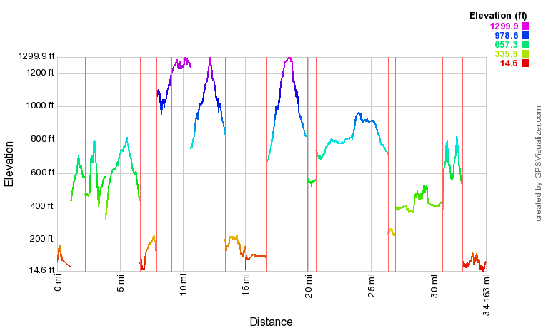
This profile is provided by GPS Visualizer
Highlights
- Wildlife. We didn't see much big game, excepting for a deer or two. But we did see lots of frogs, toads, and garter snakes. We also saw a couple of seals interacting (were they playing? fighting???) from the ferry.
- Solitude. The north end of the Sunshine Coast seems fairly populated. Powell River has a population of over 13,000 people. However, the land mass and network of trails is wide enough to experience nature all to one's self. In fact, while some of the hikes on our list were fairly populated, about half of them were not. In about 20 miles of our hiking, we counted a total of just five hikers and two mountain bikers. That's an average of one human seen every three miles of hiking!
- Marvelous weather. We enjoyed temperatures in the 70s during the day, and in the 50s at night. Temperatures nudged downward slightly throughout the week, but it was only towards the end that I even had to zip my sleeping bag up all the way. Otherwise, the weather was great for hiking during the day and sleeping during the night.
- At one point, Suzanne wondered whether some of the inlets we experienced would be like the fjords of Norway (one of our bucket list items.) Apparently, we don't have to travel as far as we thought to see such majestic coastlines!
- The Sunshine Coast Trail is a 110-mile long backcountry hut-to-hut trail that would make for an incredible backpacking itinerary. We hiked to the hut at Rieveley's pond and were amazed at its size and amenities for being so far away from civilization.
Lowlights
- Smoke. How bad was it? This bad.
- The hornets were quite agressive. We constantly had to shoo them away from our campsite or kill them outright. On one trail, we had five stings (Raymond=2, Mike=2, Suzanne=1).
- The logistics for seeing all of the Sunshine Coast is difficult because of the expensive and time-consuming ferry ride across the Jervis Inlet. The round trip ferry from Earl's Cove to Saltery Bay that seperates the north and south sections of the coast only runs a few times a day and was over $100 for one vehicle and five passengers, so it didn't make sense to go back and forth. As such, we decided to explore as much of the southern coast on the drive up and back. Perhaps we should return to explore the southern coast in more depth later.
Favorites
Here's what each family member said was their favorite part of the trip:
| Raymond: | Hidden Grove | Intricate network of trails winding through massive trees in an old growth forest |
| Amelia: | Suicide Creek | Trail through forest of aspens, pines, and madronas with an amazing viewpoint from a logging clear cut site. |
| Chris: | Soames Hill | Amazing trail network with hundreds of stair steps leading to the summit |
| Suzanne: | Inland Lake Campground | Set in a forest of cedar, maples, and madronas along the shore of a picturesque lake whose charm changed multiple times with various lighting and weather conditions |
| Mike: | Appleton Creek | Several quaint waterfalls along a rocky creek bed. |
Photos
You can take a look at all of our pictures here. There are also some videos and time lapses taken from my GoPro on this YouTube playlist.


No comments:
Post a Comment