Thursday, August 30, 2018

Sunshine Coast


I often hear recreational fishermen say, "A bad day of fishing is better than a good day at work."  This is usually said to downplay the disappointment of not catching any fish.  In that spirit, we had a few "bad days" of vacation followed by a few great days of vacation.  The trip started incredibly smoky (due to all of the wildfires in British Columbia and Washington State)... so much so that we couldn't enjoy any of the beautiful views that the Sunshine Coast affords.  But in the middle of our trip we woke up one day to beautiful clear conditions and were treated to amazing views.    

The Sunshine Coast lies along the Strait of Georgia in British Columbia, Canada.  Part of the fun of the Sunshine Coast is getting there... crossing the border, driving through Vancouver, and then taking two ferry rides across beautiful inlets to get to the north side of the coast.   While there are two halves to the Sunshine Coast separated by the second ferry, we stayed in the North half and spent most of our time up there, where it is more isolated, rugged, remote, and quiet.   

One of the many views on Inland Lake.

Hiking

We hiked over 34 miles in six days.  Even though these were largely low-elevation coastal hikes, the GPS claimed that we still climbed around 6400 feet.  As a point of comparison, my Fitbit Blaze conveyed an elevation gain of about 7000 feet, but that includes ALL daily activity (including non-hiking activity, where the GPS isn't necessarily turned on.). 

Here are the details on our individual hikes:

Hike

Approx. Elev. Gain (ft)

Distance (miles)

Soames Hill5651.6
Burnett Falls1251.1
Hidden Grove3001.2
Dinner Rock Park2351.3
Atrevida Loop5502.8
Gibralter Lookout3401.2
Rieveley's Pond2101.5
Powell River Historic District2251.7
Willingdon Trail1501.6
Appleton Creek7102.7
Haslam Lake350.7
Black Water Creek7303.2
Mud Lake / Suicide Creek4905.8
Valentine Mountain4250.8
Haywire Bay500.6
Inland Lake / Lost Lake3903.7
Valentine Mountain (Sunset)2600.8
Francis Point Provincial Park3751.9
TOTALS613534.2

GPS Info


Here is a link to our GPX file and KMZ file for Google Earth.  

Maps


This Map is provided by GPS Visualizer

Elevation Profile

We experienced a mix of hiking along the coast (colored red and yellow in the plot below, since these are near sea level), level forest hikes, and steeper climbs to great viewpoints.
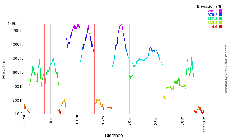
 
This profile is provided by GPS Visualizer

Highlights

  • Wildlife.  We didn't see much big game, excepting for a deer or two.  But we did see lots of frogs, toads, and garter snakes.  We also saw a couple of seals interacting (were they playing?  fighting???) from the ferry.
  • Solitude.  The north end of the Sunshine Coast seems fairly populated.  Powell River has a population of over 13,000 people.  However, the land mass and network of trails is wide enough to experience nature all to one's self.  In fact, while some of the hikes on our list were fairly populated, about half of them were not.  In about 20 miles of our hiking, we counted a total of just five hikers and two mountain bikers.  That's an average of one human seen every three miles of hiking!
  • Marvelous weather.   We enjoyed temperatures in the 70s during the day, and in the 50s at night.  Temperatures nudged downward slightly throughout the week, but it was only towards the end that I even had to zip my sleeping bag up all the way.  Otherwise, the weather was great for hiking during the day and sleeping during the night.
  • At one point, Suzanne wondered whether some of the inlets we experienced would be like the fjords of Norway (one of our bucket list items.)  Apparently, we don't have to travel as far as we thought to see such majestic coastlines!
  • The Sunshine Coast Trail is a 110-mile long backcountry hut-to-hut trail that would make for an incredible backpacking itinerary.  We hiked to the hut at Rieveley's pond and were amazed at its size and amenities for being so far away from civilization.

Lowlights

  • Smoke.  How bad was it?  This bad.
  • The hornets were quite agressive.  We constantly had to shoo them away from our campsite or kill them outright.  On one trail, we had five stings (Raymond=2, Mike=2, Suzanne=1).
  • The logistics for seeing all of the Sunshine Coast is difficult because of the expensive and time-consuming ferry ride across the Jervis Inlet.  The round trip ferry from Earl's Cove to Saltery Bay that seperates the north and south sections of the coast only runs a few times a day and was over $100 for one vehicle and five passengers, so it didn't make sense to go back and forth.  As such, we decided to explore as much of the southern coast on the drive up and back.  Perhaps we should return to explore the southern coast in more depth later.

Favorites

Here's what each family member said was their favorite part of the trip:

Raymond:Hidden GroveIntricate network of trails winding through massive trees in an old growth forest
Amelia:

Suicide Creek

Trail through forest of aspens, pines, and madronas with an amazing viewpoint from a logging clear cut site.
Chris:Soames HillAmazing trail network with hundreds of stair steps leading to the summit
Suzanne:Inland Lake CampgroundSet in a forest of cedar, maples, and madronas along the shore of a picturesque lake whose charm changed multiple times with various lighting and weather conditions
Mike:Appleton Creek

Several quaint waterfalls along a rocky creek bed.

Photos

You can take a look at all of our pictures here.  There are also some videos and time lapses taken from my GoPro on this YouTube playlist.

Wednesday, August 29, 2018

Ashland Lakes Backpack

A few friends decided to do an end-of-season backpack trip to Ashland Lakes along the Mountain Look Highway in the North Cascades.  While it was gray and rainy, and we got quite soggy on our hike out, we enjoyed great company and views of three alpine lakes (Lower Ashland, Upper Ashland, and Beaver Plant.)  The real discovery for me was that this would be a great place to take younger scouts backpacking.  It was a relatively short hike with little elevation gain that takes the hiker by three small, but pretty lakes.  There were a couple of great spots for group camping as well along with pit toilets at each lake.  


I didn't get many pictures, because the weather was not very cooperative, but here are a few that I did take.


Lower Ashland Lake, near campsite  


GPS Info

We collected all of the following data from our GPS unit during the adventure:

Maps


This Google Map is provided by GPS Visualizer

Elevation Profile

This profile is provided by GPS Visualizer

Coordinates and other details

  • Mileage: 
  • Time: 
  • Average Speed: 
  • Trailhead Coordinates: 
12.1 Miles
6:13:55 (moving)
1.94 MPH (moving)
N47 36.519' W121 23.163'


If you would like to use this info with your GPS unit, the full GPX file is here.
If you want to view this in Google Earth, you can download the KMZ files of the track and topographic overlay.

Tuesday, August 7, 2018

Sucia Island Kayaking

For high adventure, the scouts from unit 655 went to the San Juan Islands and kayaked around Sucia Island for several days.  We paddled nearly 25 miles including a trip to Matia Island.  We also enjoyed hiking, cliff jumping, awesome sunsets, and playing rugby.

Kayaks lined up during a lunch stop at Shallow Bay.


GPS Info

We collected all of the following data from our GPS unit during the adventure:

Maps


This map is provided by GPS Visualizer


Speed Profile


This profile is provided by GPS Visualizer

An album of photos from the trip can be viewed here.

Coordinates and other details

• Mileage: 24.3 mi
• Time: 8:14:44
• Speed: 3.0 MPH
• Trailhead Coordinates: N48 45.150', W122 54.440'

If you would like to use this info with your GPS unit, the full GPX file is here.
If you want to view this in Google Earth, you can download the KMZ files of the track and topographic overlay.


Saturday, July 14, 2018

Lake Dorothy Backpack

For out monthly outing, BSA troop 655 backpacked to Lakes Dorothy, Bear, and Deer in the Alpine Lakes Wilderness.  The weather was sunny and warm, barely any clouds in the sky at all.  However, the bugs were voracious--mostly annoying little gnats, but there were some biting flies and mosquitoes as well.  Here is an album that contains some shots of the scenery and the scouts in action.  I've been having fun experimenting with my new GoPro, but still have a lot to learn about capturing great footage.  There is also a time lapse of camp activity and a video of our hike out on YouTube.  (Both were too large to upload to Flickr.)


Morning Reflection on Lake Dorothy.  


GPS Info

We collected all of the following data from our GPS unit during the adventure:

Maps

This Google Map is provided by GPS Visualizer


Elevation Profile


This profile is provided by GPS Visualizer

Coordinates and other details

• Mileage: 12.1 mi
• Time: 6:13:55
• Speed: 1.94 MPH
• Trailhead Coordinates: N47 36.510', W121 23.167'

 
If you would like to use this info with your GPS unit, the full GPX file is here.
If you want to view this in Google Earth, you can download the KMZ files of the track and topographic overlay.

Saturday, May 19, 2018

Birch Bay Kayaking

For a church youth conference, Mike was in charge of a kayaking activity at Birch Bay State Park.  The activity comprised two youth from a team kayaking to grab an object off of a buoy.... blindfolded!  I rode in the back and gave no instructions at all to the first paddler.  But, the second blindfolded kayaker was given quiet instructions from me which helped them get to the buoy much quicker.  The activity was intended to educate the youth to listen to the "still small voice" of God over the din of helpful, but less informed individuals.

Meg kayaks blindfolded as she listens to the "still small voice" behind her.


GPS Info

We collected all of the following data from our GPS unit during the adventure:

Maps


Each colored track in the map below shows the tracks taken by each blindfolded youth.  The straighter tracks were those guided by the "still small voice" in the back of the kayak, while the more meandering tracks are from those who were guided by the chaotic voices of their team from the shoreline.

This Google Map  is provided by GPS Visualizer

Speed Profile

This profile is provided by GPS Visualizer

• Mileage: 1.7 mi
• Time: 0:35:14
• Speed: 2.9 MPH
• Trailhead Coordinates: N48 54.230', W122 46.282'


Saturday, May 12, 2018

Sammamish River Kayaking (Mike & Suzanne)

Mike and Suzanne tested out the new Advanced Elements inflatable tandem kayak during a beautiful Spring day along the Sammamish River.  The test proved to be educational, as we learned that we couldn't get the kayak inflated properly with the pumps that we had at our disposal.  This meant that the kayak dipped so far into the water that the deck was almost at water level.  

Suzanne paddles along the Sammamish River in Bothell, WA


GPS Info

We collected all of the following data from our GPS unit during the adventure:

Maps

This Google Map is provided by GPS Visualizer

Speed Profile


This profile is provided by GPS Visualizer  (Notice the speed increase when turning from upstream to downstream travel.)

Coordinates and other details


• Mileage:  2.0 mi
• Time:  0:57:33
• Speed:  2.07 MPH
• Trailhead Coordinates:  N47 45.546', W122 12.232'

Tuesday, August 1, 2017

Mount Baker Highway

Rarely do we travel just 400 total miles on any of our vacations, but with such a compelling destination so close to us, we took the short drive to Mount Baker and spent a week of camping, hiking, driving, geocaching, and exploring.  We had sunny skies all week with high temperatures in the seventies.  Mia was even able to take some time off of work, so she and her boyfriend, Chris, joined us for the week as well.  It was unanimous that Mounts Baker and Shuksan do not disappoint.  They are truly jaw-droppingly beautiful mountain peaks.  

We stayed at the lovely and small Douglas Fir campground near Glacier, WA and enjoyed sleeping to the tumbling sounds of the North Fork Nooksack River.  It was the perfect base camp for launching our activities along the 20-mile scenic portion of the Mount Baker Scenic Byway.Mount Shuksan behind Picture Lake.  Arguably, this is one of most photographed scenes in all of Washington State, as indicated by the number of wall calendars it finds its way into.

Hiking

We hiked nearly 24 miles in five days.  That's not even close to a Lewis family vacation record, but when you're in volcano and glacier territory like this, elevation gain is to be expected almost everywhere.  While my GPS claimed that we climbed just over 10000 feet, I've noticed that GPS trackers (at least the ones that I have owned) don't do a great job in conveying elevation accurately.  Instead, I relied on my Fitbit Blaze (which uses atmospheric pressure change to track elelvation) to determine that we climbed about 4660 feet during the week. 

Here are the details on our individual hikes:

 Hike
Distance 
(miles)
Elevation Gain
(feet)
Artist Point0.599
Bagley Lakes1.7493
Boyd Creek0.4122
Canyon Creek1.3291
Fire and Ice Trail0.7138
Heliotrope Ridge5.32835
Horseshoe Bend3.42050
Nooksack Cirque8.53487
North Fork Nooksack Research Area0.4196
Thompson Creek Ridge0.9329
TOTALS23.110040

* Elevation Gain does not convey total climb (i.e. ups and downs along the trail) 

Here is a link to our GPX file and KML file for Google Earth.  This topographic overlay also shows the steep terrain of the area as well.  GPS Visualizer created this Google map of all of our hikes as well.  

Highlights

  • The scenery is so spectacular in this area, we can't believe that the powers that be didn't include Mount Baker inside of the North Cascades National Park boundary.  At least the Heather Meadows area should've been included, since it is so close to the border.
  • The Douglas Fir campground was an awesome place to stay.  There are some really spacious sites right along the North Fork Nooksack.  The camp hosts did a great job of keeping the place tidy (including the pit toilets!)
  • Not a drop of rain for an entire week in the Pacific Northwest.  In fact, we barely saw any clouds at all! 
  • This was one of the quietest campgrounds we have ever stayed at.  Perhaps it helps that the raging North Fork Nooksack River ran through the campground, but even so, all of the campers were rather quiet.  Perhaps everyone comes here to enjoy the reverence of the area.  

Lowlights

  • Insects, insects, and more insects.  The silver lining is that they weren't doing a whole lot of biting, but the flies were out there on almost every trail we hiked on.  Luckily, we were spared at the campground.
  • Surprisingly, we came across very little wildlife.  We saw birds, insects, toads, insects, chipmunks, and insects.  Oh yeah, we also saw insects.
  • Temperatures in the mid-70s is ok when you're hiking in the shade of forest trees, but when trails opened up, the sun could seem a little too warm while wandering up steep mountain trails.
  • Because of the massive winter in the area, there were still a lot of trails closed due to snow and roads closed due to washouts.  We really wanted to do a couple of other hikes (e.g. Excelsior Peak, Chain Lakes) which were either too snowy, or completely inaccessible.  At the Heliotrope Ridge trail, we were unable to reach the Coleman Glacier due to the swift moving Heliotrope Creek.  We measured it as too deep and swift to safely cross.

Favorites


Here's what each family member said was their favorite part of the trip:
Raymond: Artist PointIncredible close-up views of Mounts Baker and Shuksan
Amelia:

 Artist Point

Incredible close-up views of Mounts Baker and Shuksan

Chris: Heliotrope Ridge Trail Mushroom Heaven!  (Chris loves to hunt for mushrooms)
Suzanne: Picture Lake360 degrees of mountains seem to circle this tiny reflective lake.  
The picture of Mount Shuksan from here is one of the most
photographed mountain scenes in the world!
Mike: Artist Point

Incredible close-up views of Mounts Baker and Shuksan


It's not too often that three of us agree on the same highlight, but that's probably a testament to the splendor of Artist Point.

Photos

We took nearly 250 pictures.  After converting panoramas and weeding out the worst images, we were able to boil it down to 180 useful scenes.  You can take a look at all of these albums here

Washington to Florida

After living in Washington state for 17 years, we decided to move to the extreme opposite end of the country to be with Mia and Mike as they...