Saturday, June 22, 2013

Barclay Lake

Mike and Raymond went with a group of scouts on a backpack trip to Barlcay Lake in the Mt. Baker-Snoqualmie National Forest.  While there were only two scouts who came, it was a very fun outing, since James Howell's cousins from Ireland came along as well.  While I've hiked this trail a couple of times, this was probably my favorite time, since we woke up to a beautiful calm lake and a sun-drenched Baring mountain facing us right across the lake.  While it took us quite a while to start a fire, because of the wet wood, James Howell and Ben Prior were persistent and got a pretty decent blaze going in the end.  In the morning, most of the group took a swim in a nice little swimming hole at the outlet of the lake.  Raymond and I excluded ourselves, because we figured that swimming in recent snow melt just wasn't our idea of a good time.  On the way back home, we enjoyed some awesome pizza at Rico's Pizza in Gold Bar. We recommend the Carribean (BBQ chicken) and the International (Combination).  Both were delicious!

Glass-like Annette Lake reflects in early morning sunlight with impressive Mount Baring in the background.  This view is so in-your-face, that it took 9 total pictures in a 3x3 panorama to get this view.  It was our first ever three-deep panorama, and Hugin came to the rescue to help create this spectacular view!


Photos and Videos

Here is an online album of photos and videos.  The videos comprise a swim that some of the group did in a nice little swimming hole at the outlet of the lake. 

GPS Info

Here is the GPS data collected during the trip:

Maps


This Google Map  is provided by GPS Visualizer.

Elevation Profile

The hike to Barclay Lake is relatively short and flat, making it an excellent destination for beginning backpackers, like the ones we took on this trip.


This elevation profile is provided by GPS Visualizer.

Coordinates and other details:

  • Mileage: 
  • Time: 
  • Average Speed: 
  • Trailhead Coordinates: 
1.7 Miles (one way)
0:49:28
2.1 MPH
N47 47.523 W121 27.543

If you would like to use this info with your GPS unit, the full GPX file is here.
If you want to view this in Google Earth, you can download the KMZ files of the track  and topographic overlay.

Sunday, June 16, 2013

Annette Lake

Mike went with a group of scouts on a backpack trip to Annette Lake in the Cascade Mountains as a part of their preparations for a 50-miler this Summer.  Unfortunately, it was a very small group who were able to make it (two to be precise), which was a shame because it was a beautiful hike, and we enjoyed sunny weather this weekend.  Suzanne and I hiked the trail the weekend before this outing, in order to assess trail conditions and provide details to the scouts as they prepared.  Amazingly, the lake was completely frozen over when we went, but it had almost entirely thawed just one week later, as seen from the photo below!


Annette Lake Panorama
A 7-frame panorama of Annette Lake in early morning sunlight.


Photos

Here is an online album of photos. 

GPS Info

Unfortunately, I only collected the GPS data for the trip into the lake, so the mileage reported would need to be doubled for a 7.0 mile round trip hike.  Here is the GPS data:

Maps


This Google Map  is provided by GPS Visualizer.

Elevation Profile


This profile was created using Garmin BaseCamp.

Coordinates and other details:

  • Mileage: 
  • Time: 
  • Average Speed: 
  • Trailhead Coordinates: 
3.5 Miles (one way)
1:48:39 (up) / 1:36:00 (down)
1.8 MPH (up) / 2.2 MPH (down)
N47 23.571, W121 28.451

If you would like to use this info with your GPS unit, the full GPX file is here.
If you want to view this in Google Earth, you can download the KMZ files of the track  and topographic overlay.

Tuesday, April 30, 2013

Grand Canyon & So. Utah

 For some time now, Mia has been asking to go to the Grand Canyon.  Logistically, there are a couple of real problems with this idea.  First, the Grand Canyon is 1400 miles away from Seattle by highway, so we'd need a lot of time to do the trip, or else we'd spend the whole time on the road.  Second, the weather makes it difficult to want to be there in the Winter or Summer!  After enough persistence from Mia, we finally came up with a solution:  Find "reasonable" airfare during Spring Break.  But, if we're going to spend money to fly, rent a car, and stay in a motel, we'd better make the trip worth it, by visiting much more than just the Grand Canyon.  In the end,  we squeezed every drop of Spring Break in order to see six national parksfour national monuments, and four state parks.


Map Courtesy of GPS Visualizer

Hiking

Our most aggressive hiking on any vacation to date, we hiked nearly 52 miles, eclipsing our previous record of 42 miles in the Canadian Rockies.  I suspect this record will last for a while, which is a testament to how much there was to see and do on this trip.  A full page hiking maps organized by area can be found here.

HikePark

Total Elev (ft)

Distance (miles)

Court of the PatriarchsZion NP

147.6

0.8

Emerald PoolsZion NP

673.9

3.4

Riverside WalkZion NP

0

1.1

Weeping RockZion NP

767.7

1.2

Inspiration PointBryce Canyon NP

196.9

0.7

Bryce PointBryce Canyon NP

56.8

0.3

Navajo Loop / Queen's GardenBryce Canyon NP

593.9

3.1

Mossy CaveBryce Canyon NP

144.4

1.1

Shakespeare ArchGrand Staircaise - Escalante NM

68.9

0.8

Cottonwood NarrowsGrand Staircaise - Escalante NM

318.5

4.5

Petrified Forest State ParkGrand Staircaise - Escalante NM

298.5

2.1

Devil's Garden - EscalanteGrand Staircaise - Escalante NM

91.9

0.7

Gooseneck / Sunset PointCapitol Reef NP

78.7

1

Capitol GorgeCapitol Reef NP

236.2

2.5

Grand WashCapitol Reef NP

126.2

3.8

Goblin ValleyGoblin Valley SP

82

1.1

Shafer CanyonCanyonlands NP

68.9

0.3

Mesa ArchCanyonlands NP

101.7

0.8

Upheaval DomeCanyonlands NP

177.1

0.8

Green River OverlookCanyonlands NP

13.1

0.2

Grand View TrailCanyonlands NP

105

2.4

Big Spring CanyonCanyonlands NP

29.4

0.2

Needles OverlookCanyonlands NP

52.5

0.5

Monitor & Merrimac Butte Overlook

Arches NP

36.1

0.2

Windows & Double ArchesArches NP

200.2

1.6

Delicate Arch ViewpointArches NP

32.8

0.3

Devil's Garden - ArchesArches NP

91.9

1.3

Sand Dune & Broken ArchesArches NP

88.5

1.6

Fiery FurnaceArches NP

26.3

0.3

Park AvenueArches NP

242.8

1.4

Horse Collar RuinsNatural Bridges NM

85.3

0.6

Kachina BridgeNatural Bridges NM

131.2

0.6

Owachomo BridgeNatural Bridges NM

206.7

0.6

Betatakin RuinsNavajo NM

269

1.4

Desert ViewGrand Canyon NP

40

0.7

Tusayan RuinsGrand Canyon NP

45.9

0.4

Mather PointGrand Canyon NP

52.4

0.5

Bright AngelGrand Canyon NP

1161.4

3.3

Maricopa PointGrand Canyon NP

32.8

0.3

Powell Point & Hope PointGrand Canyon NP

52.5

0.7

Mohave PointGrand Canyon NP

55.8

0.2

Hermit's RestGrand Canyon NP

36.1

0.2

Walnut Canyon National MonumentWalnut Canyon NM

347.7

1.3

Hoover DamHoover Dam

98.5

0.9

TOTALS

7763.7

51.8

Parks

Highlights

  • Draw-jopping scenery everywhere.  We took more pictures than on any vacation we've ever taken!
  • The Southwest has an amazing geographic diversity, and the scenery is constantly changing with very little driving.
  • Mixing it up from our normal vacation format of camping was nice
    • Sleeping in beds instead of the ground
    • Eating out gave us a variety of food to eat (of course, not having to cook was enjoyable to Suzanne) 

Lowlights

  • Because Southern Utah is a pretty remote place, accomodations can be a bit sketchy at times.  For the most part, we stayed at clean motels, but the quality in some areas was certainly less than others.
  • We had to wait an hour and a half at the rental car place, and in spite of our reservation, they didn't have any mid-size cars available for us, so we didn't get the most comfortable of rides for our 1400 mile adventure.
  • In the Spring, the weather can be downright unpredictable.  We experienced everything from sunny 70-degree weather on some days to snow and blistering cold wind on others.

Favorites

Here's what each family member said was their absolute favorite park of the trip:

Raymond:  Bryce Canyon NP
Amelia:

 Grand Canyon NP

Suzanne: Canyonlands NP 
Mike: Bryce Canyon NP

Photos

We took over 1000 pictures!  In the end, we kep 827 pictures, many of them panoramas, and placed them in 15 online Flickr albums.  You can take a look at all of these albums here.

Friday, December 28, 2012

Hatchery Creek Snowshoe

While on a winter break trip to Lake Wenatchee and Leavenworth, we explored a snowshoe trail along Hatchery Creek just off of US Route 2.  During the trip, Raymond lost one of the snow baskets from his trekking poles, making it a bit difficult for him to maneuver with just one pole that didn't sink into the snow.  We were hoping to get to a small pond to see if it was frozen over, but we were running low on daylight (and energy!) so we didn't make it there, but we still had a great time exploring the peaceful winter wonderland.


GPS Info

We collected all of the following data from our GPS unit during the adventure:

Maps


This Google Map  is provided by GPS Visualizer

Elevation Profile


This profile is provided by GPS Visualizer

Coordinates and other details

  • Mileage: 
  • Time: 
  • Average Speed: 
  • Trailhead Coordinates: 
1.4 Miles
01:45
1.9 Miles/Hr.
N47° 40.694', W120° 44.085'


Leavenworth Tubing

During the winter break, we took a trip to Lake Wenatchee to spend a couple of days in the snow.  Our family friend, Dale Partna, was nice enough to let us stay in his cabin for two nights after Christmas and we had a blast in the snow.  On one outing, we checked out the tubing hill at the Leavenworth Winter Sports Club.  It was about 30 degrees, but we bundled ourselves up and enjoyed the outing--at least until Suzanne bruised her bottom as she bounced too hard in the tube during one run, and the kids started complaining about headaches.   While we didn't take any pictures, we did want to show our GPS data that shows the drop and speed of the run, coming down the 500-foot long hill that drops about 100 feet to the bottom.  It wasn't as much fun as the tubing hill at Bogus Basin, but it was still enjoyable.   


GPS Info

We collected all of the following data from our GPS unit during the adventure:

Maps


This Google Map  is provided by GPS Visualizer

Elevation Profile


This profile is provided by GPS Visualizer

Speed Profile


This profile is provided by GPS Visualizer

Coordinates and other details

  • Mileage: 
  • Time: 
  • Tubing Speed: 
  • Trailhead Coordinates: 

0.8 Miles
00:52\
23 Miles/Hr.
N47° 36.807, W120° 40.107


If you would like to use this info with your GPS unit, the full GPX file is here.
If you want to view this in Google Earth, you can download the KMZ files of the track  and topographic overlay.

Wenatchee Showshoe

During the winter break, we took a trip to Lake Wenatchee to spend a couple of days in the snow.  Our family friend, Dale Partna, was nice enough to let us stay in his cabin for two nights after Christmas and we had a blast in the snow.  One afternoon, Mia and I went scouting on snowshoes to find the Wenatchee River from Dale's cabin.  On a previous visit, Dale took us on snowmobiles to a spot along the river, but Mia and I are pretty sure that we didn't follow the same path, based on the fact that we did some serious cross-country snowshoeing, including a couple of episodes with tree wells.  Fortunately, we had each other to help out of the wells, and the snow was only a few feet deep, so we never got into any truly sticky situations.  You can see from the speed profile below, where we got bogged down going across country, while towards the end, we got so comfortable in the snowshoes and terrain that we practically raced back to the cabin.


GPS Info

We collected all of the following data from our GPS unit during the adventure:

Maps


This Google Map  is provided by GPS Visualizer

Speed Profile

This profile is provided by GPS Visualizer

Coordinates and other details

  • Mileage: 
  • Time: 
  • Average Speed: 
  • Trailhead Coordinates: 
1.4 Miles
01:22
1.0 Miles/Hr.
+47° 47' 28.74", -120° 38' 59.88"

 
If you would like to use this info with your GPS unit, the full GPX file is here.
If you want to view this in Google Earth, you can download the KMZ files of the track  and topographic overlay.

Monday, July 30, 2012

Idaho Panhandle

 Because we live in Seattle, where the winters are gray and wet, we wanted to find some sun.  On our Northwest Oregon vacation, the weather was just ok, but we still didn't get enough sun, so we decided to try on a second summer trip to get even better weather.  As a result, we headed to the other east side of the Cascades, and drove to the Idaho Panhandle.  While our Oregon vacation could be considered a trip of waterfalls, Northern Idaho can be considered a land of lakes.  The big three are:

  • Coeur d'Alene Lake (Voted by National Geographic as one of the 10 most beautiful lakes in the world.)
  • Lake Pend Oreille (Deep enough that the US Navy performs underwater submarine research there.) 
  • Priest Lake (and Upper Priest Lake, which is only 13 miles from the Canadian border.)

This was a little bit different of a vacation from most, as we did comparably little hiking (only seven miles in three hikes.)  We did do plenty of scenic driving, putting over 500 miles on the car, which is significant, considering that the panhandle is less than 50 miles wide.  The two main activities for this trip were boating on Priest Lake and visiting Silverwood Theme Park

By the way, we did find the sun that we desired.  Skies were blue and sunny, with highs in the mid 70s to low 80s.  It was exactly what we were looking for!


Map Courtesy of GPS Visualizer

Hiking

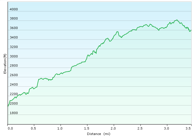
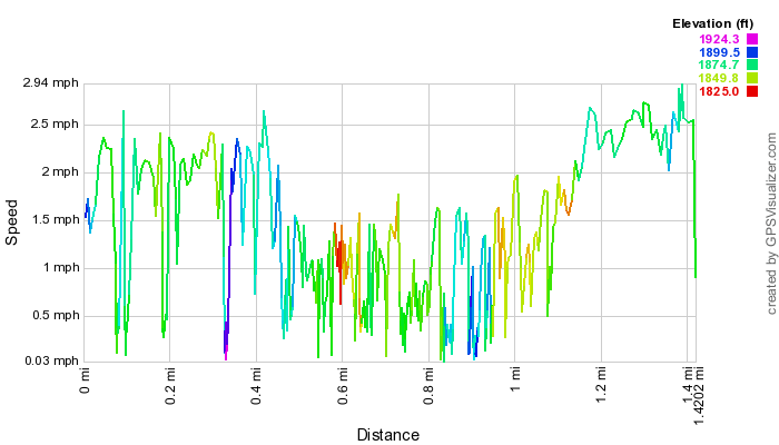
We only hiked 7 miles on this trip.  The details for each hike are shown below.  Mineral Ridge afforded us some great views of Coeur d'Alene Lake, while Moose Lake was a very quiet trip off the beaten path to a remote alpine lake.  We only passed 2 groups hiking back there in the 2.5 hours we spent back on the trail, including a nice picnic at the lake.

HikeDistance (miles)Elevation (ft)
Mineral Ridge2.7700
Moose Lake3.3550
Deep Creek1.00
TOTAL7.01250

Boating

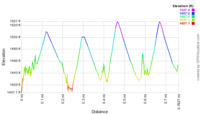
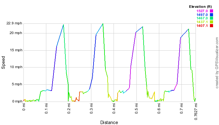
Of the three lakes we could've spent time on, we were glad to choose Priest Lake.  It was a quieter alternative, that gave us a chance to boat two lakes for the price of one!  Upper Priest Lake is a remote lake with no vehicular access.  You only get there by boat or foot.  A 2.5 mile thoroughfare (part of the Priest River) connects it with Priest Lake, and it was an beautiful and leisurely trip too.  We spent about 8 hours on the lake cruising, tubing, and swimming a total of 67 miles. 

Silverwood Theme Park

Silverwood is the only major theme park in the Pacific Northwest, and since the kids haven't been to a theme park since our Disneyland vacation back in 2005, we figured they had been deprived long enough, and that it was time to give them a chance to experience it again.  While Raymond didn't take much to roller coasters (he hated riding the corkscrew, and got a terrible headache afterwards), Amelia loved them, and so she made her mother and I go on several, including the 4.5 G-force Aftershock, one of five Giant Inverted Boomerangs in the world.  Along with Nick Norton's Mysterium magic show and a nice lunch at Lindy's restaurant, here is a list of rides we took in while at Silverwood and the companion Boulder Beach water park:

Favorites

Here's what each family member said was their absolute favorite activity of the trip:

Raymond:  Boating on Priest Lake
Amelia:

  Boating on Priest Lake

Suzanne:  Moose Lake
Mike:  Lunch Peak Lookout

Photos

We took over 180 pictures of our trip to Idaho.  You can take a look at our online photo album here

GPS

Here is a link to our .gpx file that has all of our hiking, driving, and boating details.

Dice Tower East

Well, this is a rarity of a vacation as far as the Lewis Family is concerned.  There is nothing outdoorsy or campish about this one.  So why...