Saturday, July 16, 2022

Sammamish River Kayak (Woodinville)

It has been a while since the kayak has come out of its bag, and since Suzanne and I are planning a kayaking trip on Sucia Island next month, we figured we should break it out to make sure everything was in working order.  We launched at Brackett's Landing and travelled upstream past Wilmot Gateway Park in Woodinville.  We spotted a blue heron and a river otter that came up out of the water for the briefest of moments.  There were relatively few paddlers that direction, as most tend to stay closer to Bothell Landing.

Sammamish River vegetation in Woodinville.

GPS Info

We collected all of the following data from our GPS unit during the adventure:

Maps


This Leaflet Map is provided by GPS Visualizer


Speed Profile


From the following profile, it's evident that we went upstream first, but the Sammamish River is so calm that the currents don't really hold back too much.  There was one section where we had to paddle hard to overcome the current of an incoming stream, but for the most part, this was a very easy paddle.


This profile is provided by GPS Visualizer

• Mileage: 4.5 mi
• Time: 1:43:15
• Speed: 2.6 MPH
• Put-in Coordinates: 47.7546, -122.1935


Photos

While this trip was really intended to be a gear check, we did take a few photos of the river that can be seen here.


Saturday, July 9, 2022

Greider Lakes

For my next training hike, I opted to revisit Greider Lakes in the Morning Star Natural Resources Conservation Area.  The day started out mostly sunny at the trailhead on Spada Lake, but as I reached the pair of alpine lakes, the clouds had come in and greyed everything out.  Of course, as I headed back down the trail, the skies opened up again.  For a second straight hike, I was foiled in being able to capture the beauty of  Washington's alpine lakes.  

But, the point of this hike really was to assess my readiness for a multi-day backpack to Glacier Peak Wilderness next month.  The sole purpose was the test of a 9.2 mile round-trip hike with 2500 feet of elevation gain, most of which comes over 40 switchbacks that cover 1.5 miles of trail.  Much less crowded than Serene Lake, I only saw about 50 hikers in my 6.5 hours on the trail.

There were some awesome wildflowers to enjoy along the trail as well.  With a book that Suzanne recently gave me, "Wildflowers of the Pacific Northwest", I was able to identify the following:

  • Dwarf Dogwood
  • Red Columbine
  • Foxglove
  • Common Dandelion
  • Daisy (Not sure what kind... would need a better picture to identify)


Little Greider Lake


Big Greider Lake

GPS Info

Here is the data from the GPS unit:

Maps


This Leaflet Map is provided by GPS Visualizer


Elevation Profile


This profile is provided by GPS Visualizer

Coordinates and other details


  • Mileage:
  • 9.2 Miles
  • Elevation
  • 2537 Feet
  • Time:
  • 6:45:56 (total), 4:40:50 (moving)
  • Average Speed:
  • 1.36 MPH (total), 1.96 MPH (moving)
  • Trailhead Coordinates:
  • 47.9741, -121.6136

    The GPX file can be downloaded here.

    Photos and Videos


    Photos are available at this album, while a YouTube video is available here.

    Monday, July 4, 2022

    Serene Lake / Bridal Veil Falls

    In an effort to assess physical preparedness for a possible multi-day backpacking trip in August, Mike loaded up his pack with 30 pounds of gear for a day hike to Serene Lake and Bridal Veil Falls on the Fourth of July.  Chosen for its difficulty, this hike was 8.6 miles round-trip with 3000 feet of elevation ascent.   Knowing of the popularity of this destination, Mike arrived at the trailhead at 6:45 AM for easy parking--only 10 other cars were there at that time of the morning.

    Trying to keep count of hikers along the way, he counted approximately 250 on the hike to and from Serene Lake, and another 150 past Bridal Veil falls!  That's a lot of hikers on one trail as attested by the fact that both parking lots filled, and cars still had to park along the forest road as well.


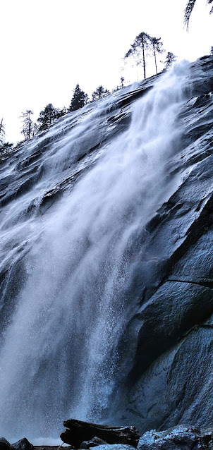
    Bridal Veil Falls

    Bridal Veil Falls (East Cascade)

    GPS Info

    Here is the data from the GPS unit:

    Maps


    This Leaflet Map is provided by GPS Visualizer


    Elevation Profile


    This profile is provided by GPS Visualizer


    Coordinates and other details


  • Mileage:
  • 8.6 Miles
  • Elevation
  • 2904 Feet
  • Time:
  • 6:32:02 (total), 4:47:58 (moving)
  • Average Speed:
  • 1.31 MPH (total), 1.78 MPH (moving)
  • Trailhead Coordinates:
  • N 47° 48.553, W 121° 34.400

    The GPX file can be downloaded here.

    Photos and Videos


    Photos are available at this album, while a YouTube video is available here.


    Chain Lakes Loop

    On the first day of autumn, Mike was able to get in one final Saturday of good weather for a day hike to give him over 50 miles of hiking in...