Saturday, September 27, 2008

Emmett Geocaching


On a beautiful fall day, we decided to go up to Emmett, Idaho for some geocaching.  We had a successful trip, finding all 12 geocaches that were attempted, deferring the attempt on four of them due to location--we decided to get the biggest bang for the buck.  We even brought Grandma Jo along with us to help find some of the geocaches.  Every member of the family found at least one cache, and Grandma found at least three of them herself.  All of the pictures from the trip can be found here.


Amelia and Raymond examine the contents of a cache on Freezeout Hill, above Emmett, Idaho.


Geocaches Attempted

Traditional CacheA Bridge No MoreFound
Traditional CacheCan I hear Niagra?Found
Traditional CacheCobblestone OverviewFound
Traditional CacheCobblestone ParkFound
Traditional CacheCobblestone TrioFound
Traditional CacheGot Bicycle Parts?Found
Traditional CacheGOT CANCER?Passed
Traditional CacheI SEA NEMOPassed
Traditional CacheJAG - It's Just a GamePassed
Traditional CacheOld Freeze Out RoadFound
Traditional CachePayette River OverlookFound
Traditional CachePet Cemerety ????Found
Traditional CacheRim with a View #9Found
Traditional CacheRoad by the RiverPassed
Traditional CacheThomas' First HideFound
Traditional CacheThorny OneFound

GPS Info

We collected all of the following data from our GPS unit during the adventure:

Maps


This Google Map is provided by GPS Visualizer

Elevation Profile


This profile is provided by GPS Visualizer

Coordinates and other details

  • Mileage: 
  • Time: 
  • Average Speed: 
  • Trailhead Coordinates: 
78.2 Miles
4:34:37
17 MPH
"Geocaches Attempted" links above contain coordinates


If you would like to use this info with your GPS unit, the full GPX file is here.
If you want to view this in Google Earth, you can download the KMZ files of the track and topographic overlay.

Friday, August 1, 2008

Glacier Waterton International Peace Park

 "Third time's a charm!" That's exactly how many times it took us to get to Glacier National Park in Montana, and it was more than worth the wait.  When we first tried to visit the park last August, we found ourselves needing to change plans just a couple of days away from the start of our vacation.  With all of the lightning-induced fires that had plagued Idaho and Montana last summer, we took one last look at the webcams in the park, and decided that it just wasn't going to be an enjoyable trip with all of the smoke up there.

No problem... we'll just go in June next time to beat fire season, right?  Wrong!  By the end of June, the Going-to-the-Sun (GTTS) Road was still closed due to snow.  Wow!  What a difficult park to visit, and what a narrow window of opportunity between snow and fire.  So, we waited out one more month of the summer, and finally made it!

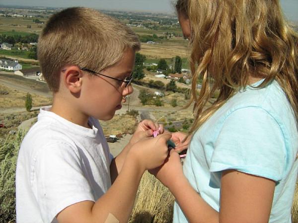
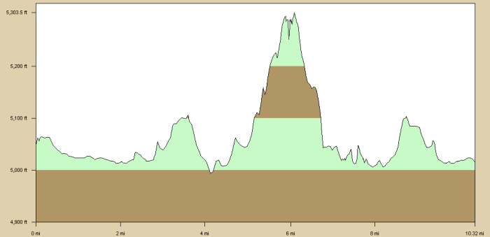
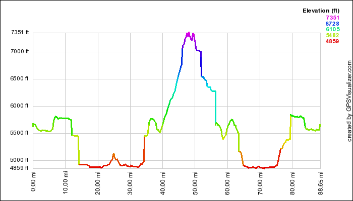
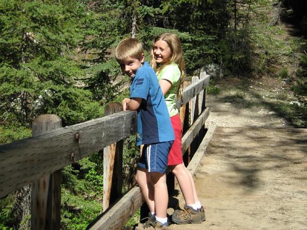
In ten days, we put 1500 miles on the car: 500 to get to the park, 500 driving around there, and 500 to get back.  Even so, Glacier may be one of the least-geared National Park's for driving.  The GTTS disects the park going east-to-west, but to really see the park, you need to get out on the trails.  The park has about 100 miles of well-travelled roadways, and about 700 miles of trails.  That's why we ended up hiking nearly 40 miles, with a total elevation gain of over 5400 feet.  Total climb distance (all of the ups between the low and high elevation of each hike) was around 9000 feet!  No wonder the kids were complaining by the time we were done!  Amelia and Raymond were real troopers both on the trail and in the car... particularly during that 13-hour dash home.

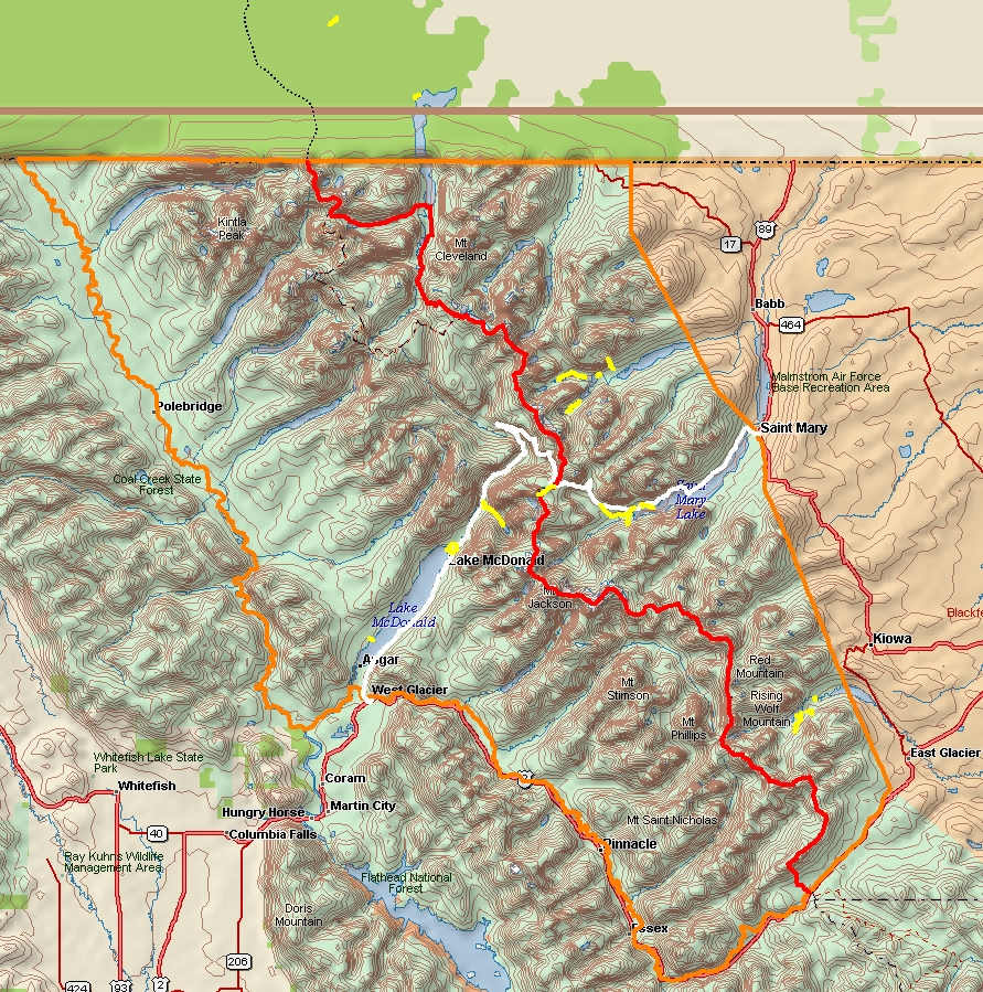
The following map of Glacier comes from of Delorme Topo USA. The legend for the map is:
  • Park boundary (orange)
  • Continental Divide (red)
  • Going to the Sun Road (white)
  • Hikes we took (yellow) [including two hikes north of the 49th parallel... i.e. Canada]


Highlights

While there were plenty of scenery to enjoy at many turnouts along the roads, we found that you really do have to hike to see the beauty of this park.  It is logically divided up into glaciated valleys, as follows.  Numbers indicate the hike as shown on the map linked to in the main bullet heading.
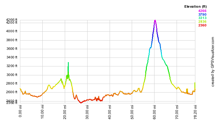
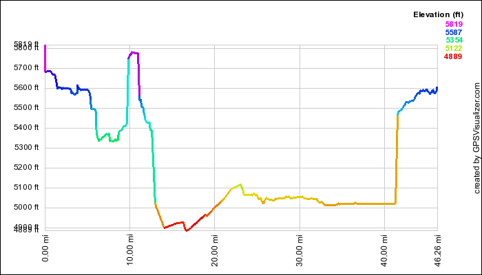
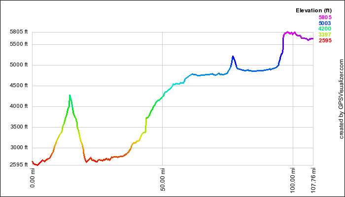
Here is a map for each of the five areas courtesy of GPS Visualizer:


Lowlights

It's hard to complain about the beauty of Glacier, or how well the vacation went in general, but here is a small list of complaints:
  • Even with 6 lodging establishments and over 1000 campsites, the campgrounds are packed!  You gotta act fast if you want to get a campsite.
  • Campsites can be a bit tight at many of the campgrounds.  We had a hard time finding good campsites that would accomodate our tent.
  • We wanted the weather to cooperate with us 100% of the time... but we happily settled for 90%.
  • Not that we didn't expect it, but the insects can be pretty annoying--not to mention tenacious!
  • This is one very busy park.  We found very few opportunities to be away from massive crowds, even though this park is very far away from any major population.  We did find that Waterton Lakes National Park... Glacier's partner in Canada, was much less visited, but still highly enjoyable.

Favorites

Here's what each family member said was their absolute favorite activity of the trip:

Raymond:Shuttle Bus on GTTS Road
Amelia:Shuttle Boats on Swiftcurrent, Josephine Lakes
Suzanne:Redrock Falls Hike
Mike:Best Picnic Spots ever! (Avalanche Lake, Grinnell Lake, Paradise Point, & Redrock Falls)


Takeaways

Here are a few final thoughts from our vacation:
  • Wildlife.  Glacier National Park is truly wild!  No wonder they beat it into car campers to put EVERYTHING away that could potentially attract bears into the campgrounds.  We saw deerelkmoosebearbighorn sheep, and even the cute hoary marmot.  
  • We thought we were totally fulfilled after seeing the juvenile grizzly that bounded across the road in front of our car in Canada, but when we saw a full-sized grizzly bear come directly at us out of the brush about 30 yards away from our trail... well, that gave us quite a start!  Needless to say, we got ourselves as quietly as possible up the path before snapping a couple of quick pictures and moving on.
  • We'd just learned the night before about the mischeivous marmot, so when we saw the little rodent sneaking around the shuttle boat shelter where unsuspecting park visitors left there belongings while waiting on the shore of the lake, we knew exactly what he was up to.  No sooner could we alert the group of people about the marmot's presence, we turn to see the guy quickly hauling off his prey--the defenseless sweatshirt never knew what hit it.  Being closest to the critter, I bolted after him and was able to pluck it from him before he disappeared around the corner and restored it to its proper owner, who couldn't help laugh at the antics of the overstuffed squirrel.
  • Walking back from Red Rock Falls, we noticed a couple approaching us from down the trail.  Compleletly unaware, we noticed a large object move across the trail behind them.  Through the trees, there was no mistaking the distinct profile of a female moose, right where another trail went off to Fishercap Lake.  We slowly and quietly wandered down the path, but never again saw the moose until we got to the shore of the lake, where a crowd of awe-struck spectators where already starting to watch the moose amble out into the shallow lake for some feeding.  Across the lake, we could hear at least one more moose groan under the protection of a thicket of trees.
  • The bighorn sheep was a ewe that we saw right in the parking area of the Many Glacier Hotel.  She was just grazing there right beside our car as we drove by.  In fact, we had to proceed carefully, because she was right in the road for a moment and we weren't sure that she was going to stay out of the way.  Animals have little fear of people when they are protected by National Park status.
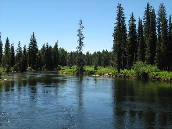
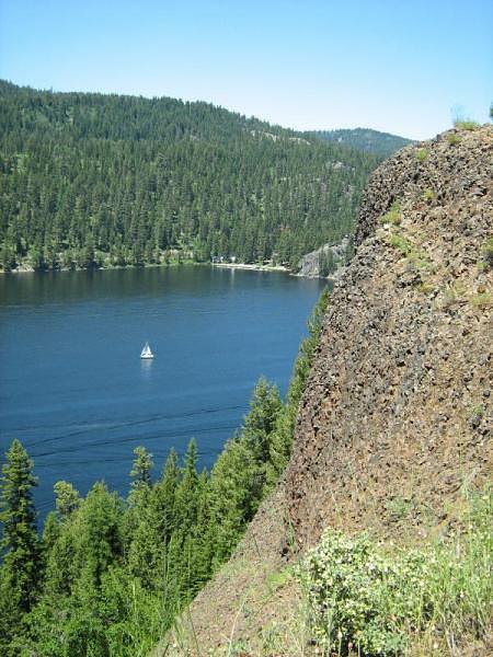
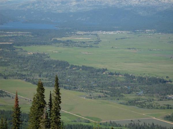
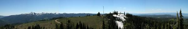
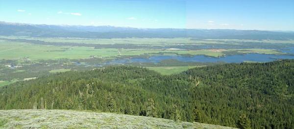
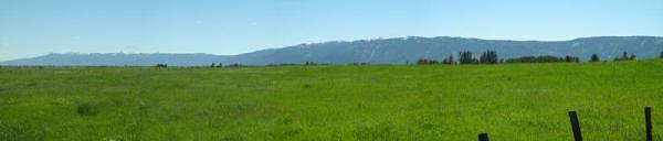
  • Breath-taking scenery.  We don't expect our pictures will do much justice to the magnificence of the scenery.  Rushing creeks, pounding waterfalls, massive glaciated valleys, gorgeous hanging valleys, rocks of every color, steep and jagged mountains, and turquoise-colored lakes kept our jaws dropped for the entire trip.  In fact, in many settings, we couldn't get the scene in one picture, so we took nearly 30 panoramics and stitched them together afterwards with hugin.
  • Weather.  From hazy to crystal clear; still air, to gusty wind; rain, hail and abundant sunshine.  Expect everything when you're in glacier...  As they say, "if you don't like the weather, just wait."  We were blessed with mostly excellent weather, but never did get to see Logan Pass on the Continental Divide with any sunlight on it.

Photos

As you've come to expect from the Lewis Family, there are loads of pictures to wade through from our vacation.  We found so many panoramic scenes, that we snapped more pans on this trip than any other.  Thank goodness for hugin, which allows us to easily piece together panoramas from multiple pictures!  It's a real lifesaver!  We've uploaded the following five albums consisting of 325 pictures!  
There were so many photogenic views, that pictures just seemed to take themselves.

Tuesday, July 29, 2008

Upper Payette Lake Drive

On the last day of a camping trip near Cascade, Idaho, we ventured up to some uncharted territory.  We went through McCall and the lovely Payette Lake to the less-crowded Upper Payette Lake for a picnic lunch, and some photos, of course.  One of Idaho's many fires last year had affected the Upper Payette, but it was still a lovely drive.


North Fork Payette River between Upper Payette Lake and Payette Lake.


GPS Info

We collected all of the following data from our GPS unit during the adventure:

Maps

This Google Map is provided by GPS Visualizer.


Elevation Profile


This profile is provided by GPS Visualizer.

Coordinates and other details

  • Mileage: 
  • Time: 
  • Average Speed: 
46.3 Miles
01:41:32
27 Miles/Hr.

If you would like to use this info with your GPS unit, the full GPX file is here.
If you want to view this in Google Earth, you can download the KMZ files of the track and topographic overlay.

Ponderosa State Park

The land on which Ponderosa State Park sits may be some of the most coveted and beautiful in Idaho.  Sitting on the 2.5 mile long peninsula on gorgeous Lake Payette, there are several miles of trails for hiking and biking in the summer, as well as for nordic skiing and snowshoeing in the winter.  Driving to the end of the peninsula, we were treated to some wonderful panoramic views of the lake and McCall, Idaho from the 300-foot tall basalt cliffs.  While there, we also took a brief hike around part of a lily marsh, but considering how warm it got, we couldn't endure much more than 1/2 mile. 


A sailboat floats on the Narrows of Payette Lake below Ponderosa State Park


GPS Info

We collected all of the following data from our GPS unit during the adventure:

Maps


This Google Map is provided by GPS Visualizer.


Elevation Profile


This profile is provided by Delorme Topo USA.

Coordinates and other details

  • Mileage: 
  • Time: 
  • Average Speed: 
10.3 Miles
01:21:04
8 Miles/Hr.

If you would like to use this info with your GPS unit, the full GPX file is here.
If you want to view this in Google Earth, you can download the KMZ files of the track and topographic overlay.

Monday, July 28, 2008

Long Valley Drive

The aptly-named Long Valley is over 42 miles long, and only about 6 miles wide at its widest.  We could not stop taking pictures of this beautiful valley near our campground in the Payette National Forest.  The highlight was discovering No Business Lookout, which we would have never discovered had we not been encouraged by a geocache... one of the biggest benefits to geocaching is finding some of the amazing places that you'd never stumble upon on your own!


Looking north from No Business Lookout towards Lake Payette and McCall on the north end of Long Valley.  According to the profile below, the lookout is about 2500 feet in elevation above the valley floor, which makes for a most impressive view!

 Views

There were lots of panoramic opportunites.  Here are a few that we stitched together:


Looking West from No Business Lookout towards Council Mountain


Looking South from No Business Lookout towards Cascade Lake


Long Valley Panorama


GPS Info

We collected all of the following data from our GPS unit during the adventure:

Maps


This Google Map is provided by GPS Visualizer.


Elevation Profile


This profile is provided by GPS Visualizer.

Coordinates and other details

  • Mileage: 
  • Time: 
  • Average Speed: 
88.7 Miles
05:00:05
18 Miles/Hr.

If you would like to use this info with your GPS unit, the full GPX file is here.
If you want to view this in Google Earth, you can download the KMZ files of the track and topographic overlay.

Sunday, July 27, 2008

Kennally Creek Hike

In our Idaho camping guide book, we found a really cool campground nestled in the Payette National Forest.  At the campground, a trailhead begins along the Kennally Creek, which was swollen with snow run-off during our visit.  A five-mile round trip hike through dense forest, by grassy meadows, over slithering snakes (*gulp*) and the cascading creek. We were away from everyone (we literally came across nobody!) made for a very enjoyable hike.  By the way, while leading the group, it was Raymond who stepped right over the racer snake before he realized what it was.  He got himself out of there in a flash, and was  freaked out for a while.  We even found a geocache way out along the trail, and it had only been partially-eaten by some curious critter who found it before we did.


Kids take a moment to enjoy the rushing North Fork of the Kennally Creek as they stand on the bridge along the trail.


GPS Info

We collected all of the following data from our GPS unit during the adventure:

Maps


This Google Map is provided by GPS Visualizer.

Elevation Profile

This profile is provided by GPS Visualizer.


Coordinates and other details

  • Mileage: 
  • Time: 
  • Average Speed: 
  • Trailhead Coordinates: 
5.1 Miles
03:23:09
1.5 Miles/Hr.
N 44 46.870, W 115 52.451

If you would like to use this info with your GPS unit, the full GPX file is here.
If you want to view this in Google Earth, you can download the KMZ files of the track and topographic overlay.

Saturday, July 26, 2008

Payette River Scenic Byway (North)

While we had already driven the Southern section of the byway several times, we haven't explored or recorded the northern half of it very much, so we wanted to make a page dedicated to the entire drive.  The northern half is very beautiful as it winds through the Payette National Forest, right along the rapidly flowing North Fork of the Payette River, which is considered by some experts to be one of the most challenging river reaches in North America, if not the world.  We took quite a few pictures of the entire camping trip that can be seen here.  


Rafters prepare for rapids along the North Fork of the Payette River.


GPS Info

We collected all of the following data from our GPS unit during the adventure:

Maps

This Google Map is provided by GPS Visualizer.


Elevation Profile


This profile is provided by GPS Visualizer.

Coordinates and other details

  • Mileage: 
  • Time: 
  • Average Speed: 
108 Miles
02:16:02
48 Miles/Hr.


If you would like to use this info with your GPS unit, the full GPX file is here.
If you want to view this in Google Earth, you can download the KMZ files of the track and topographic overlay.

Dice Tower East

Well, this is a rarity of a vacation as far as the Lewis Family is concerned.  There is nothing outdoorsy or campish about this one.  So why...