Saturday, July 26, 2008

Payette River Scenic Byway (North)

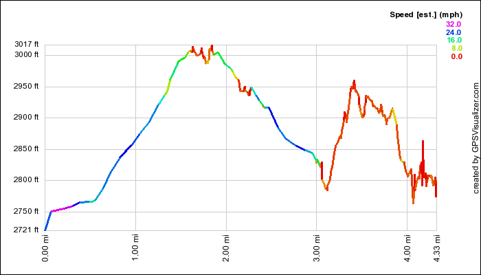
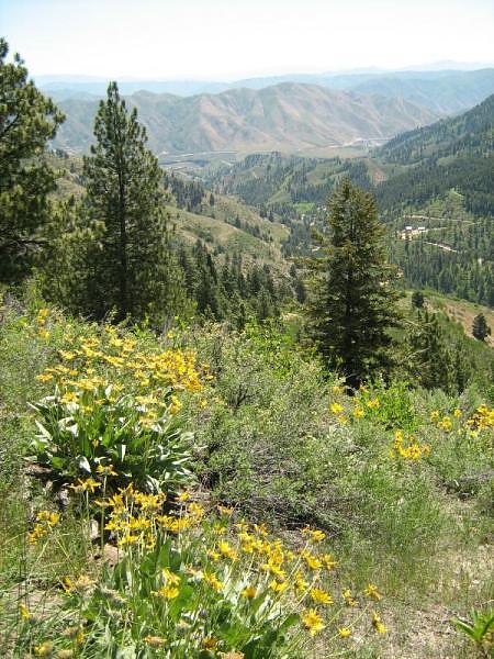
While we had already driven the Southern section of the byway several times, we haven't explored or recorded the northern half of it very much, so we wanted to make a page dedicated to the entire drive.  The northern half is very beautiful as it winds through the Payette National Forest, right along the rapidly flowing North Fork of the Payette River, which is considered by some experts to be one of the most challenging river reaches in North America, if not the world.  We took quite a few pictures of the entire camping trip that can be seen here.  
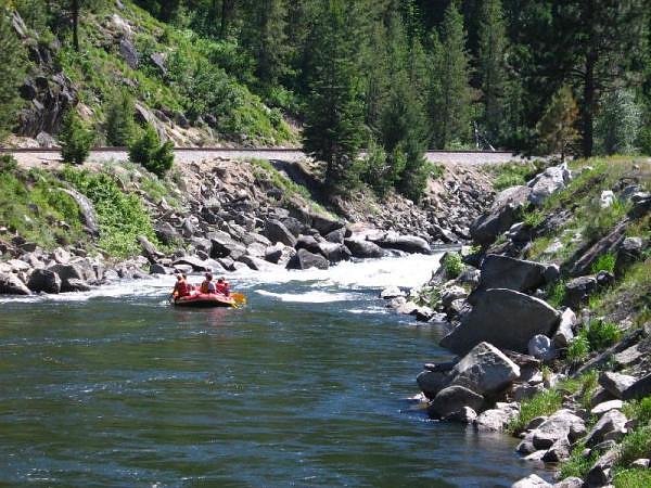

Rafters prepare for rapids along the North Fork of the Payette River.


GPS Info

We collected all of the following data from our GPS unit during the adventure:

Maps

This Google Map is provided by GPS Visualizer.


Elevation Profile
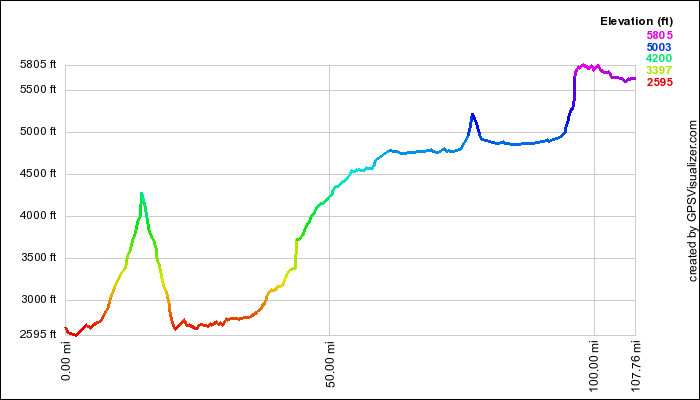

This profile is provided by GPS Visualizer.

Coordinates and other details

  • Mileage: 
  • Time: 
  • Average Speed: 
108 Miles
02:16:02
48 Miles/Hr.


If you would like to use this info with your GPS unit, the full GPX file is here.
If you want to view this in Google Earth, you can download the KMZ files of the track and topographic overlay.

Saturday, June 21, 2008

Eagle Greenbelt Geocaching

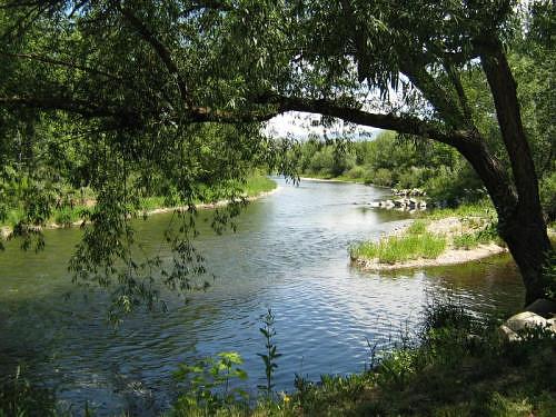
Before getting too hot on Saturday morning, we went to the Boise River Greenbelt and hunted for more geocaches, while enjoying a stroll along the river.  It still got pretty warm even by noon, when we had got back to the car after our 2.6 mile hike... however,  we were glad we got out early when we saw the mercury hit the century mark later in the day.


Boise River view from the Greenbelt in Eagle, Idaho.


Geocaches Attempted


Traditional CacheAt The BeginningFound
Traditional CacheRainbow Series #1Found
Traditional CacheRainbow Series #2 Somewhere Over the Rainbow...Found
Traditional CacheRainbow Series #3Missed
Traditional CacheRainbow Series #4Found
Traditional CacheRainbow Series #5Missed
Traditional CacheRainbow Series #6Found
Traditional CacheRainbow Series #7Skipped
Traditional CacheRainbow Series #8 - The End of the RainbowMissed

GPS Info

We collected all of the following data from our GPS unit during the adventure:

Maps


This Google Map is provided by GPS Visualizer

Time Profile

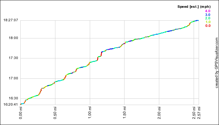
Since this was a relatively flat stroll along the river, an elevation profile is meaningless.  However, we thought that a time profile might be interesting.  In this profile, the steeper parts of the curve are where we were going much slower, or were stopped altogether.  The red portions, for the most part, are where we were hunting for geocaches.  By the time we got to the end of the greenbelt, you can see that we returned without doing nearly as much stopping.


This profile is provided by GPS Visualizer

Coordinates and other details

  • Mileage: 
  • Time: 
  • Average Speed: 
  • Trailhead Coordinates: 
2.6 Miles
2:06:26
1.2 MPH
"Geocaches Attempted" links above contain coordinates


If you would like to use this info with your GPS unit, the full GPX file is here.
If you want to view this in Google Earth, you can download the KMZ files of the track and topographic overlay.

Saturday, June 14, 2008

Rocky Canyon Geocaching


After a ward campout near Idaho City, we decided to take do some geocaching along a scenic route home.  We were favored with great weather and a list of ten geocaches in our GPS.  We had our most productive geocaching ever, having found nine caches in a single day.  And the tenth, we simply passed by because it was in a public park, and didn't want to draw attention to the cache. 


View from Boise Ridge looking towards Robie Creek and Lucky Peak State Park

Geocaches Attempted

Traditional Cache"E" GasFound
Traditional Cache'Snow Way ThruFound
Traditional CacheAldape RaptorsFound
Traditional CacheDusty RhodesFound
Traditional CacheGrayback GulchFound
Traditional CacheJames' Foothills CacheFound
Traditional CacheRocky Canyon 1Found
Traditional CacheRocky Canyon Road cacheFound
Traditional CacheRooney's RobieSkipped
Traditional CacheWrong Way to Robie CreekFound

GPS Info

We collected all of the following data from our GPS unit during the adventure:

Maps


This Google Map is provided by GPS Visualizer

Elevation Profile

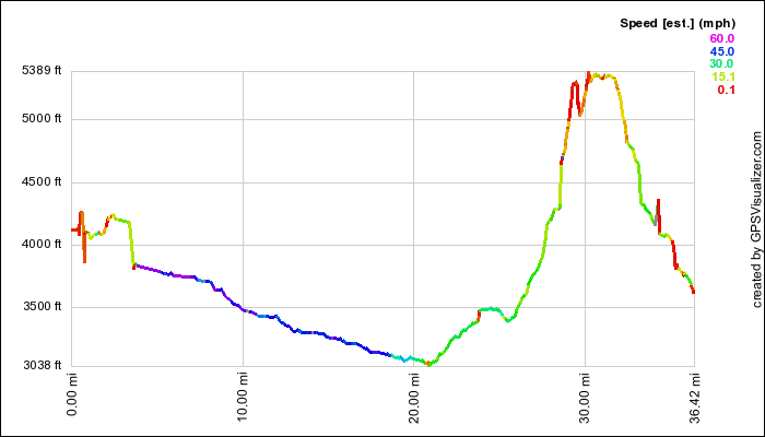
The elevation profile conveys three different main coloring schemes.  
  • Blue/Purple: highway travel.  
  • Green/Yellow: dirt road travel
  • Red/Orange: walking (while finding geocache... as you can tell, there were some calf-burning slopes to climb for some of these.)

This profile is provided by GPS Visualizer

Coordinates and other details

    Mileage: 
    Time: 
    Average Speed: 
    Trailhead Coordinates: 
36.4 Miles
4:16:26
9 MPH
"Geocaches Attempted" links above contain coordinates

If you would like to use this info with your GPS unit, the full GPX file is here.
If you want to view this in Google Earth, you can download the KMZ files of the track and topographic overlay.
Saturday, May 10, 2008

Boise Greenbelt Walk

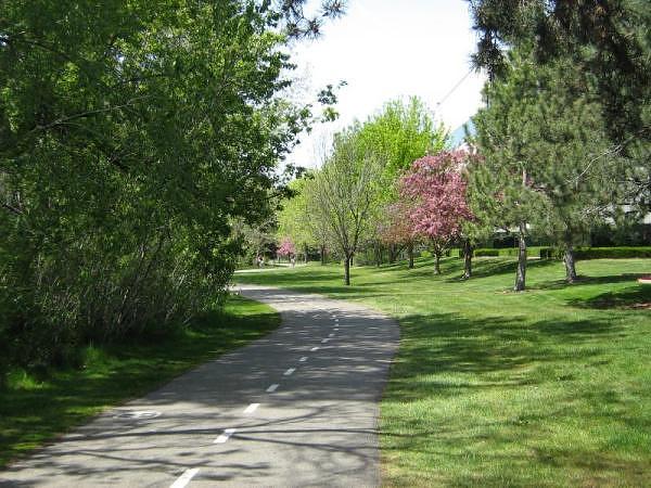
Well, the weather is improving nicely, and so we took advantage of the Mothers' Day weekend to talk a stroll along the Boise River Greenbelt between Ann Morrison Park and Julia Davis Park, with Boise State University along the way.  We also took the opportunity to stop by the Idaho Ann Frank Human Rights Memorial for a few minutes... something we haven't seen since moving to Boise.  Turns out, we weren't the only ones with the idea.  Cyclists, joggers, skateboarders, roller bladers, and strollers like ourselves were out in force.


Boise River Greenbelt at the NW 0.3 marker (as seen in the white circle in the bottom left of the picture)


GPS Info

We collected all of the following data from our GPS unit during the adventure:

Maps


This Google Map is provided by GPS Visualizer

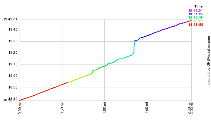
Time Profile 

This profile shows our relative rate of travel.  Steeper portions of the curve are slower.  For example, the steep light blue curve shows the 10 minutes that we stopped at the Anne Frank memorial.

This profile is provided by GPS Visualizer

Coordinates and other details

  • Mileage: 
  • Time: 
  • Average Speed: 
  • Trailhead Coordinates: 
2.0 Miles
1:10:06
1.7 Miles/Hr.
N 43 36.730, W 116 13.065
 
If you would like to use this info with your GPS unit, the full GPX file is here.
If you want to view this in Google Earth, you can download the KMZ files of the track and topographic overlay.

Friday, March 28, 2008

Military Reserve Geocaching


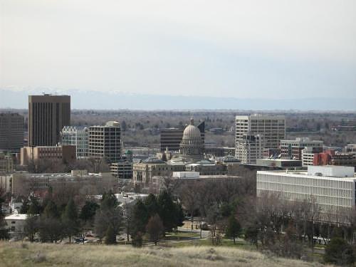
Adjacent to downtown Boise sits an old Military Reserve.  Now reserved as a city park, it offers nearly 500 acres of excellent mountain biking, hiking, and views of Boise, the Treasure Valley, and the Owyhee Mountain range on the other side of the valley.  Mike took the kids up during an early spring weekend to do some geocaching as well.


Downtown Boise from Elephant Rock Loop Trail


GPS Info

We collected all of the following data from our GPS unit during the adventure.  Since this track is a mixed hiking/driving map, colors are used to indicate speed.  Red and orange sections denote hiking, whereas blue and green colors depict driving through the park to get from one cache to another.

Maps


This Google Map is provided by GPS Visualizer

Elevation Profile


This profile is provided by GPS Visualizer

Coordinates and other details

  • Mileage: 
  • Time: 
  • Average Speed: 
  • Trailhead Coordinates: 
4.3 Miles
1:50:30
2 Miles/Hr. (mixed driving/hiking)
Refer to individual geocache pages above for coordinates to each cache.


If you would like to use this info with your GPS unit, the full GPX file is here.
If you want to view this in Google Earth, you can download the KMZ files of the track and topographic overlay.
Sunday, February 17, 2008

Hoodoo Showshoe

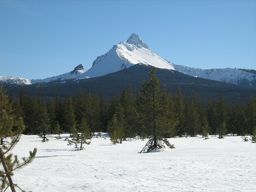
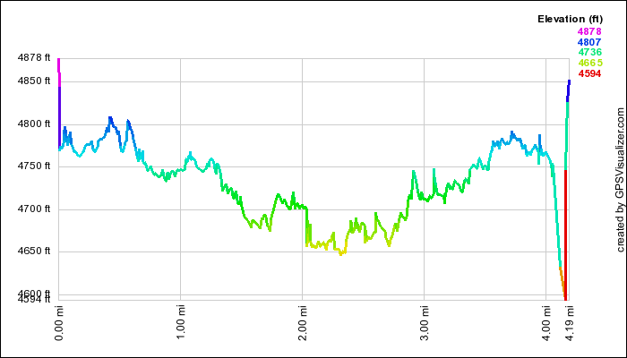
On our get-away to Oregon's Central Cascades, we took a snowshoe trip near Hoodoo Ski Resort.  The snow was very icy, so we didn't have to worry about sinking into powder.  We had magnificient views of a couple of peaks in the Cascades, as well a couple  of  downhill skiiers coming down the very steep backside of Hayrick Butte.  The run drops an average of one foot of vertical distance for every two feet of horizontal distance.  At the top, the angle is about 45 degrees!  If you look closely enough, you can see the ski tracks here.  You can see the full set of pictures from the outing here.

Mt. Washington from meadow on South Loop at Ray Benson Sno Park.


GPS Info

We collected all of the following data from our GPS unit during the adventure:

Maps


This Google Map is provided by GPS Visualizer

Elevation Profile


This profile is provided by GPS Visualizer

Coordinates and other details

  • Mileage: 
  • Time: 
  • Average Speed: 
  • Trailhead Coordinates: 
4.2 Miles
02:25
2 Miles/Hr.
N44 24.281 W121 51.723


If you would like to use this info with your GPS unit, the full GPX file is here.
If you want to view this in Google Earth, you can download the KMZ files of the track and topographic overlay.
Saturday, February 16, 2008

Pilot Butte Hike

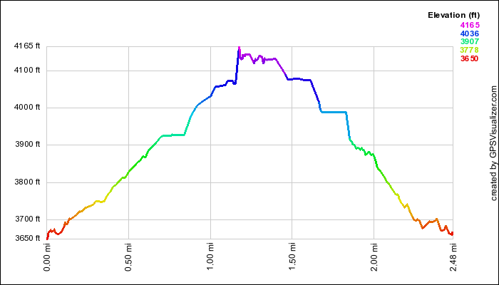
One of the highlights of our Central Oregon getaway was this hike to the top of an old cinder cone volcano in Bend, Oregon.  With commanding views of the Cascades, we were highly impressed that we could see the entire Oregon Cascade range, all the way up to Mount Hood, over 90 miles away!  While we were expecting to be able to drive to the top of the butte, the road is closed during the winter season, but the 2-mile, 500-foot hike to the top was well worth the view.


This 7-Frame Panorama of the Central Oregon Cascades includes views of Mt. Bachelor, Broken Top, The Three Sisters, Three-Fingered Jack, Mt. Washington, Mt. Jefferson, and Mt. Hood.


GPS Info

We collected all of the following data from our GPS unit during the adventure:

Maps


This Google Map is provided by GPS Visualizer

Elevation Profile


This profile s provided by GPS Visualizer

Coordinates and other details

  • Mileage: 
  • Time: 
  • Average Speed: 
  • Trailhead Coordinates: 
0.6 Miles
00:28
1.3 Miles/Hr.
N 44° 3' 27.79", W 121° 16' 42.45"


If you would like to use this info with your GPS unit, the full GPX file is here.
If you want to view this in Google Earth, you can download the KMZ files of the track and topographic overlay.

Washington to Florida

After living in Washington state for 17 years, we decided to move to the extreme opposite end of the country to be with Mia and Mike as they...