Monday, September 4, 2006

Boise River Float

One of the most popular summer family activity in Boise is to float the Boise River.  It's a peaceful stretch of the river, with a couple of fast sections the kids loved.  We even got stuck on some rocks at one point. The stretch of the river from Barber Park to Julia Davis Park is about 6 miles, and it took us exactly two hours to complete it.  We split up each hour-long leg with a picnic lunch at one of the rest stops along the river.
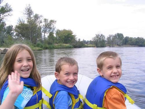

The kids loved floating down the Boise River


GPS Info

We collected all of the following data from our GPS unit during the adventure:

Maps

This Google Map is provided by GPS Visualizer
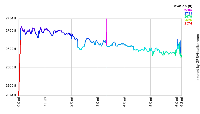
Elevation Profile


This profile s provided by GPS Visualizer

Coordinates and other details

  • Mileage:  
  • Time:
  • Average Speed:
  • Put-in Coordinates: 
6.1 Miles
2:03:39
3 Miles per Hour
N 43 34.076, W 116 08.070
 
If you would like to use this info with your GPS unit, the full GPX file is here.
If you want to view this in Google Earth, you can download the KMZ files of the track and topographic overlay.

Friday, September 1, 2006

Sawtooth National Recreation Area

Sometimes, you don't need to travel far from home to have a wonderful vacation.  One of our shortest-travelled vacations ever also turned out to be one of our most impressive. While it is just 135 miles from our home to our campsite in the Sawtooth National Recreation Area (SNRA), the last 110 miles of it follow three of Idaho's Scenic Byways.  It was certainly one of the most spectacular destinations we've enjoyed in all of our years of vacations.  We took lots of photos to remember it by.


This is a map of our vacation courtesy GPS Visualizer.

Highlights

We certainly did pack in plenty of activities in our six nights of camping!

Lowlights 

No, it wasn't the perfect vacation, as there were some downsides to it along the way, but it certainly was one of our more enjoyable vacations ever!  The camping was relaxing enough and the scenary superb enough to deal with the following less-than-ideal situations.
  • Mosquitos, mosquitos, and more mosquitos.  The repellent just didn't turn these guys away!
  • A couple of days of rain kept us off the trailhead
  • Early season obstacles (flooding, trees across roads) kept us away from some geocaches, hikes, and drives that we were interested in.

Favorites

Here's what each family member said was their absolute favorite activity of the trip:
  • Trent:  The Shuttle Boat on Redfish Lake
  • Raymond:  Throwing Rocks in Lake Stanley
  • Amelia:  Redfish Creek Falls
  • Suzanne:   Fishhook Meadow Hike
  • Mike:  Valley of the Giants Hike

Takeaways

Some final thoughts from our vacation:
  • The Sawtooth Mountains truly live up to their name.  With several jagged peaks above 10,000 feet, these are some truly impressive mountains
  • The Stanley Lake Campground that we stayed at presented us with the most impressive view we've ever had of any campground we've stayed at.
  • The area also boasted several large mountain meadows, containing lush grasses and filled with early summer wildflowers.
  • Every river, creek, and stream was swollen beyond normal measure due to the abnormally large snows this winter, and the rapidly warming
  • It was fun to find a couple of geocaches, but we learned to not always trust our GPS!
  • The history along the Custer Motorway presented us with a rich and enjoyable history of the area.  It was an unplanned, and unexpected delight to our trip.
  • 200+ photos from our digital camera can't possibly lies

Sunday, July 30, 2006

Sawtooth Wilderness Backpack

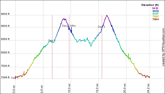
This is our first-ever backpack trip.  Backpacking is something Mike has wanted to do his whole life, and we were not disappointed with the activity.  Yes, we overdid it, hiking over 24 miles in three days while covering nearly 5000 feet of climb distance.  We got blisters, and plenty of mosquito bites.  However, it was all worth it in the end.  Nestled in the heart of Idaho, the Sawtooth National Wilderness Area has some of the most spectacular scenary we've ever enjoyed!  Rushing creeks, crystal clear lakes, towering mountain peaks, and lush meadows left us in awe after for the last half of the hike.  We saw nearly a dozen lakes and several creeks and cascades.  Take a look at our online photo album for some of the views that we enjoyed.


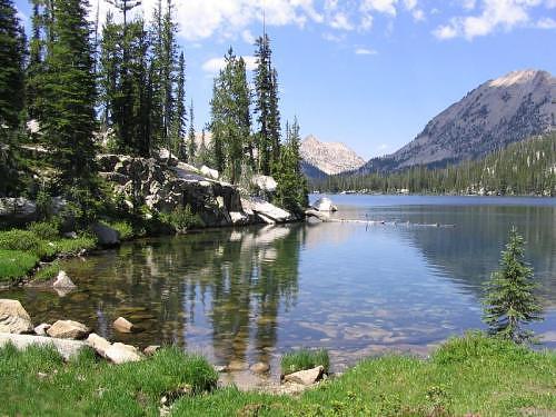
Cove on Edna Lake, Sawtooth Wilderness Area


GPS Info

We collected all of the following data from our GPS unit during the adventure:

Maps


This Google Map is provided by GPS Visualizer

Elevation Profile


This profile is provided by GPS Visualizer


Coordinates and other details

  • Mileage: 
  • Time: 
  • Average Speed: 
  • Trailhead Coordinates
  • Toxaway Lake Campsite Coordinates:  
  • Rendevouz Lake Campsite Coordinates
24.2 Miles
04:19:22
1.5 Miles/Hr.
N 43° 59.776, W114° 52.796
N 43° 57.817, W 114° 58.262
N 43° 58.604, W 114° 58.469

 
If you would like to use this info with your GPS unit, the full GPX file is here.
If you want to view this in Google Earth, you can download the KMZ files of the track and topographic overlay.
Tuesday, June 13, 2006

Yankee Fork Drive

Typically, when we plan our vacations, we have a set of things that we'd like to do and see.  The Yankee Fork Drive (a.k.a. Custer Motorway) was not on that list when we left for our Sawtooth vacation.  In fact, we hadn't ever heard of the Yankee Fork before we left.  Instead, it was a very spontaneous trip that we made after finding some signage along the Salmon River Scenic Byway.  It turned out to be one of the most pleasant and enjoyable aspects of our trip.


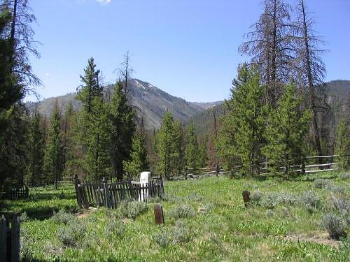
Ghost towns, old cemetaries, historic stories, mining equipment, and a museum in an old school house were delightful components of the drive.  Gold mining scars from old-time dredging are notably obvious all along the Yankee Fork of the Salmon River.


Wooden grave markers are scattered amongst some more modern tombstones
depict the harsh lifestyle of the gold mining town of Bonanza, Idaho.


GPS Info

We collected all of the following data from our GPS unit during the adventure:

Maps


This Google Map is provided by GPS Visualizer


Elevation Profile


This profile is provided by GPS Visualizer.


Coordinates and other details

  • Mileage: 
  • Time: 
  • Average Speed: 
  • Starting Coordinates:  
  • Ending Coordinates
8.0 Miles
18:03
27 Miles/Hr.
N 44º 16.249, W 114º 44.082
N 44º 22.355, W 114º 43.633

 
If you would like to use this info with your GPS unit, the full GPX file is here.
If you want to view this in Google Earth, you can download the KMZ files of the track and topographic overlay.
Salmon River Scenic Byway

Overall, we really didn't cover a whole lot of this byway.  There's still plenty to explore.  However, we really did enjoy the views along the Salmon River as well as some of the history of the area.  We would've explored this road more, except that we spent the rest of the day exploring the Yankee Fork of the Salmon River--an alternate connector between Sunbeam, ID and Challis, ID--which pleasantly distracted us from the attempt.


This historic dam along the Salmon River was briefly used for hydroelectric power generation for gold mining establishments along the Yankee Fork.  Once the gold ran out and the power was no longer needed, the dam was blown up in order to allow a more natural and ecological flow of the river.


GPS Info

We collected all of the following data from our GPS unit during the adventure:

Maps


This Google Map is provided by GPS Visualizer


Elevation Profile


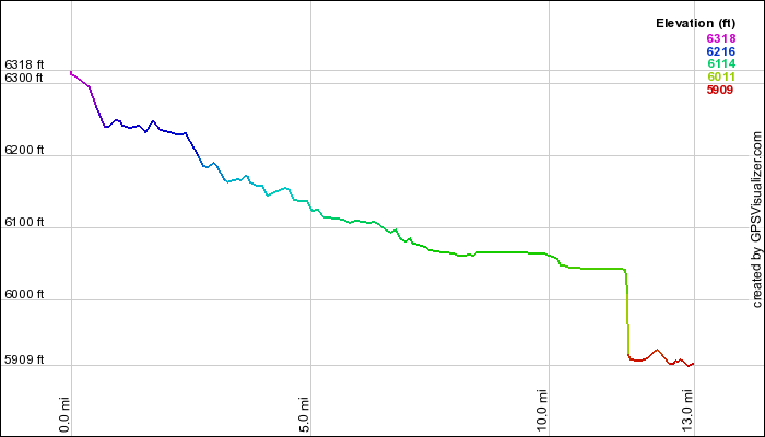
This elevation profile is provided by GPS Visualizer


Coordinates and other details

  • Mileage: 
  • Time: 
  • Average Speed: 
  • Starting Coordinates:  
  • Ending Coordinates:
13.0 Miles
19:37
40 Miles/Hr.
N 44º 12.983, Wº 114 55.806
N 44º 16.263, Wº 114 44.226


If you would like to use this info with your GPS unit, the full GPX file is here.
If you want to view this in Google Earth, you can download the KMZ files of the track and topographic overlay.
Friday, June 9, 2006

Dagger Falls Drive

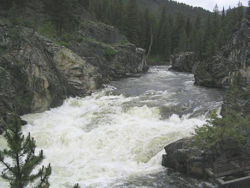
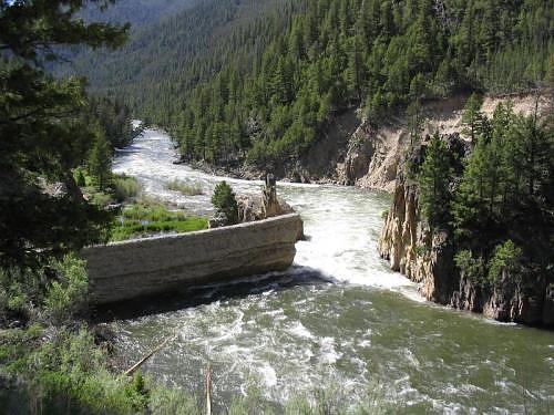
By definition a wilderness area typically precludes vehicular activity of any sort.  One exception to that is a road that ventures into the Frank Church River of No Return Wilderness, the largest wilderness area in the contiguous 48 United States.  The road was allowed in order to provide white water enthusiasts with access to the Middle Fork of the Salmon River.  For us, the highlight of this trip was watching a kayaker put-in just above the falls during peak run-off of an exceptionally snowy year.  What a ride!


Dagger Falls on the Middle Fork of the Salmon River.  We saw a kayaker completely disappear in the froth for a second or two shortly after putting in above the falls!


GPS Info

We collected all of the following data from our GPS unit during the adventure:

Maps

This Google Map is provided by GPS Visualizer


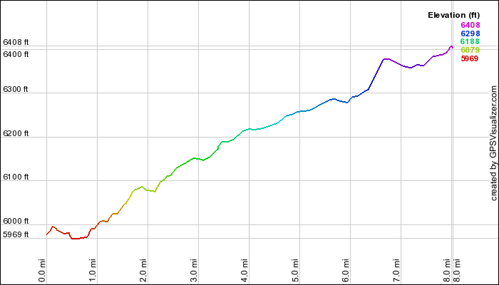
Elevation Profile


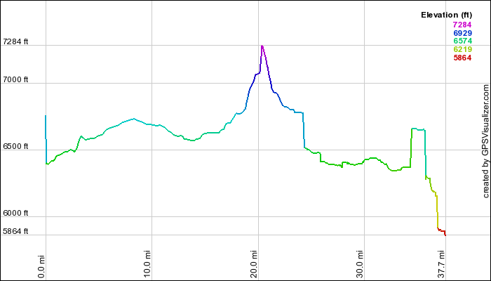
This profile is provided by GPS Visualizer


Coordinates and other details:

  • Mileage: 
  • Time: 
  • Average Speed: 
  • Beginning Coordinates:  
  • Ending Coordinates
37.5 Miles
1:23:00
27.0 Miles/Hr.
N 44º 15.513, W 114º 59.782
N 44º 31.719, W 115º 17.169

If you would like to use this info with your GPS unit, the full GPX file is here.
If you want to view this in Google Earth, you can download the KMZ files of the track and topographic overlay.
Sunday, October 30, 2005

Chocolate Gulch

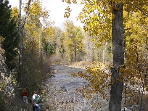
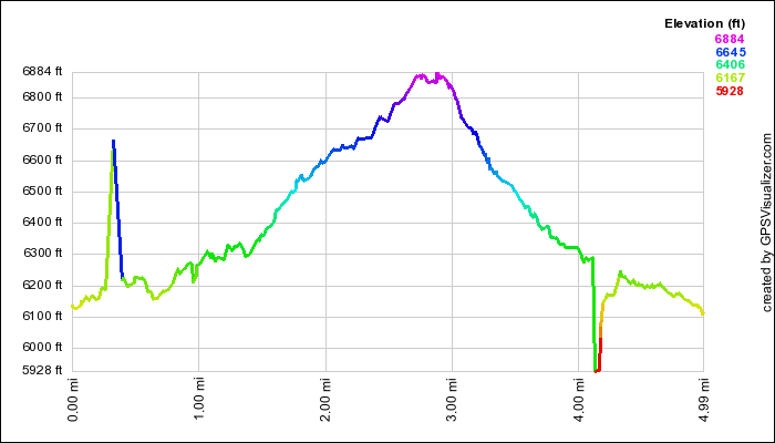
Shortly after moving to Idaho, we wanted to experience some of the Fall color in our area.  Hearing about the Big Wood River area near Sun Valley Ski Resort, we opted to take a weekend drive and check it out.  While we went a little late in the season, we were still very impressed with the yellows, reds, and oranges mixed in with the evergreens of the elevation that still abounded in the area.


Chocolate Gulch Trail along the Big Wood River near Ketchum, Idaho


GPS Info

We collected all of the following data from our GPS unit during the adventure:

Maps


This Google Map is provided by GPS Visualizer

Elevation Profile


This profile is provided by GPS Visualizer

Coordinates and other details

  • Mileage: 
  • Trailhead Coordinates: 
5 Miles
N 43 45.400 W 114 24.090

If you would like to use this info with your GPS unit, the full GPX file is here.
If you want to view this in Google Earth, you can download the KMZ files of the track and topographic overlay.
Washington to Florida

After living in Washington state for 17 years, we decided to move to the extreme opposite end of the country to be with Mia and Mike as they...