Overall, we really didn't cover a whole lot of this byway. There's still plenty to explore. However, we really did enjoy the views along the Salmon River as well as some of the history of the area. We would've explored this road more, except that we spent the rest of the day exploring the Yankee Fork of the Salmon River--an alternate connector between Sunbeam, ID and Challis, ID--which pleasantly distracted us from the attempt.
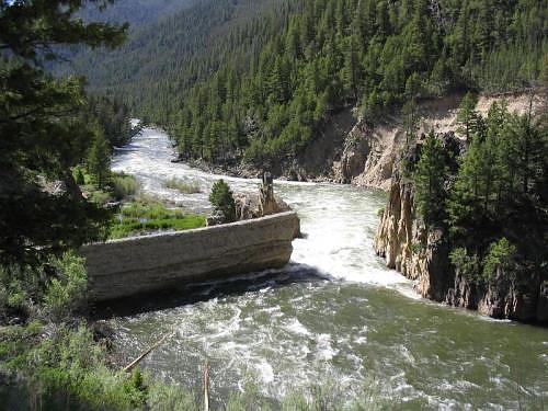
This historic dam along the Salmon River was briefly used for hydroelectric power generation for gold mining establishments along the Yankee Fork. Once the gold ran out and the power was no longer needed, the dam was blown up in order to allow a more natural and ecological flow of the river.
GPS Info
We collected all of the following data from our GPS unit during the adventure:Maps
This Google Map is provided by GPS Visualizer
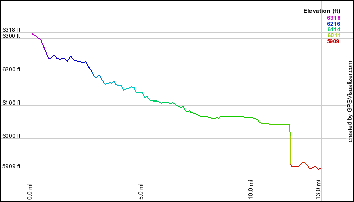
This elevation profile is provided by GPS Visualizer
If you would like to use this info with your GPS unit, the full GPX file is here.
If you want to view this in Google Earth, you can download the KMZ files of the track and topographic overlay.
Elevation Profile
This elevation profile is provided by GPS Visualizer
Coordinates and other details
| 13.0 Miles 19:37 40 Miles/Hr. N 44º 12.983, Wº 114 55.806 N 44º 16.263, Wº 114 44.226 |
If you would like to use this info with your GPS unit, the full GPX file is here.
If you want to view this in Google Earth, you can download the KMZ files of the track and topographic overlay.


No comments:
Post a Comment