Saturday, June 30, 2012

Northwest Oregon

The day after the 2011-2012 school year ended, we headed to Oregon to celebrate the beginning of summer.  Unfortunately, while the weather forecast looked largely sunny, we discovered that Oregon wasn't as ready to start summer as we were.  But, really, we can't complain.  Most of the rain happened at night, but by the end of our stay, we did decide to pack up our soggy campsite a day earlier than planned, simply because of more rain in the forecast.  It turns out, that the rain wasn't the only thing that made our vacation water-filled.  We explored the Pacific Ocean, lakes, rivers, and nearly 20 waterfalls on this trip!  In the end, we explored nearly 750 miles of Oregon in the car, and another 25 on our feet.

We also took a day to visit Portland.  It was the kids first trip there, and they really enjoyed it.  We visited the Pittock Mansion (pictured below), the marvelous Japanese Gardens (rated 2nd in the country by the Journal of Japanese Gardening), the immense International Test Rose Garden with 550 species of roses on display, the World Forest Center, and we even tried to get lost in massive Powell's Book Store.  It took us over an hour to check out all of the different rooms, and in the end, with that amazing inventory, we somehow managed to emerge with only five new books!

Pittock Mansion - Portland, Oregon

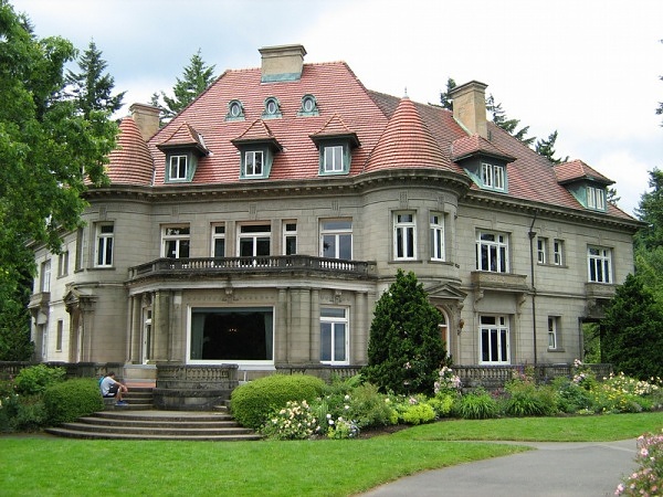
Pittock Mansion (1914) in Portland, Oregon

Hiking

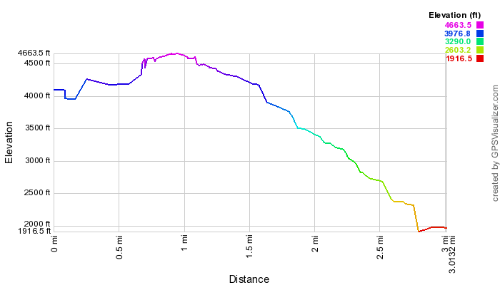
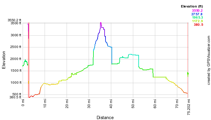
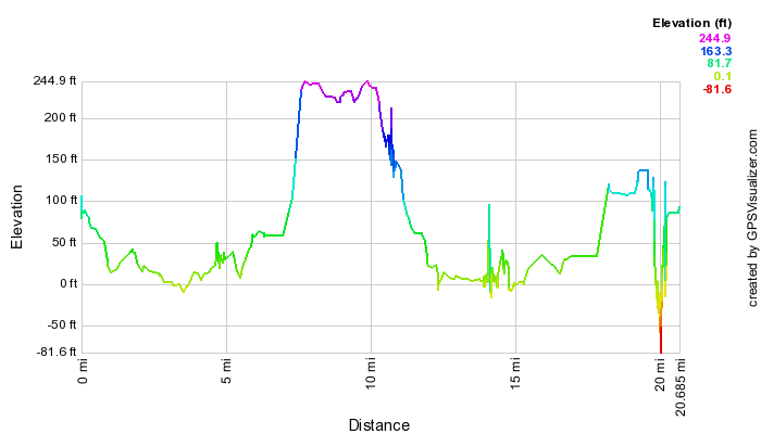
We hiked 24.8 miles in 6 days (average of 4.1 miles per day).  The following table contains a summary of all of our activity.  Here is a map of all of our hikes, courtesy of GPS Visualizer:


HikeDistance (miles)Elevation (ft)
Bridal Veil Falls 0.6167.3
Cape Foulweather 0.236
Cape Lookout State Park (Beach) 0.632.8
Cape Lookout State Park (Cape) 4.5554.4
Cape Meares State Park 0.8216.5
Devils Punch Bowl State Park 0.229.6
Fort Stevens State Park (Historic Walk) 0.736.1
Fort Stevens State Park (Battery Russell) 0.362.3
International Test Rose Garden 0.7167
Japanese Gardens 0.8147.6
Multnomah Falls 0.7242.8
Munson Creek Falls 0.4154.2
Oxbow Regional Park 0.4154.2
Rocky Creek State Park 0.223
Seaside Promenade 0.988.6
Silver Falls State Park (Central) 2.6726.4
Silver Falls State Park (East) 1.3465.8
Silver Falls State Park (West)1.2258.7
Tamanawas Falls 3.6820.2
Trillium Lake 2.4216.5
Wakeena Falls 0.5183.7
Yaquina Head State Park 1144.4
TOTAL24.64928.1

Highlights

  • Waterfalls everywhere!  From the Columbia River Gorge, to Silver Falls State Park, the Coastal Range, and Mt. Hood, we saw nearly 20 spectacular waterfalls, and that doesn't even touch the surface of what's available.  We were able to see so many falls, from so many angles, above, below, in front... even behind!  There were four falls that we could walk all the way behind.  It was a very different, unique, and surreal experience for all of us.
  • The Oregon Coastline is rugged and spectacular.  We especially enjoyed being able to get some views from 500 foot high cliffs. 
  • Camping on the Coast was a first for us.  We were pleasantly surprised with the size of our campsite.  True, there was no shade, but there was hedges around each site for privacy.  It was nice being able to hear the sound of the waves at night, but not so much the fierce winds that blew the tents around on our last night. 
  • Seeing the Tillamook Cheese Factory was an enjoyable treat for all of us.  We eat so much Tilamook cheese that it was pretty cool to see how it is all produced.
  • The kids really loved playing in the waves of the ocean.  Even though they didn't bring their swimsuits, assuming the water would be too cold, they still jumped in.  Mia went all the way under in her street clothes even... silly girl!
  • Seeing Mount Hood from the Timberline Lodge ski resort was quite impressive.  Suzanne pointed out how small one feels, standing right up against 14,000-foot tall mountain.  We were lucky enough to get a glimpse of it out of the clouds just when we showed up at the lodge.

Lowlights

  • We would've preferred better weather.  It certainly could've been worse, but coming from Seatlle, we were really wanting more sun than we got.
  • Not enough time to see it all.  Even if we hadn't got cut short by a day, we still wouldn't have been able to see all that we wanted to.
  • Campfires are tough to build when it is humid and wet... also doesn't help when your campground sells you wet wood!

Favorites

Here's what each family member said was their absolute favorite activity of the trip:

Raymond:Swimming in the Ocean
Amelia:

Swimming in the Ocean (although the Cheese Factory and Winter falls were close runners up.)

Suzanne:Silver Falls State Park
Mike:Silver Falls State Park


Photos

Sunday, September 11, 2011

Blanca Lake Backpack

As a new (and very out-of-shape) scout leader, my first backpacking trip with the varsity team of unit 525 was to one of the most beautiful glacial-fed lakes in the Cascade Mountains.  More popular as a day hike (there aren't many developed campsites around the lake), Blanca Lake in the Henry M. Jackson Wilderness is absolutely idyllic.  The hike is an absolute grind however, with dozens of switchbacks climbing up 2600 feet of elevation gain..... in just two miles.  


If you want to see just how photogenic this lake and hike were, just point your browser here.

The Cascades reflect off of glass-like conditions on the Blanca Lake.  The green water comes from glacial silt deposited from the Columbia Glacier higher up in the Mountains

GPS Info

Unfortunately, I only got GPS data for the return trip, so total mileage reported needs to be doubled for a round trip trip of 6.0 miles.  Also, the elevation profile below only shows the descent out of Blanca Lake, but not the hike in from the day before.

Maps


This Google Map is provided by GPS Visualizer

Elevation Profile


This profile is provided by GPS Visualizer

Coordinates and other details

  • Mileage: 
  • Time: 
  • Average Speed: 
  • Trailhead Coordinates: 
3.0 Miles
2:52:58 (total),  1:56:21 (moving)
1.05 MPH (total), 1.55 MPH (moving)
47 54'55.0"N 121 18'45.0"W


If you would like to use this info with your GPS unit, the full GPX file is here.
If you want to view this in Google Earth, you can download the KMZ files of the track and a topographic overlay plugin.

Friday, July 15, 2011

Canadian Rockies

For a long while, the Canadian Rockies have featured pretty high on our list of places to visit.  Now that we live in the Pacific Northwest, it is an easy day drive (approximately 11 hours) to get to the Rockies.  Once there, however, we planned on spending 10 days there in a dash to visit 6 national parks (Iisted in the order visited):

Glacier
Mount Revelstoke
Yoho
Banff
Kootenay
Jasper

We ended up putting 2300 miles on the car, and over 40 miles on our feet hiking around.  The scenary and wildlife were spectacular.  In fact, trails.com claims that the Icefield Parkway, which links Banff and Jasper National Parks, "is one of the premier mountain drives on earth".  You can be the judge when you see our photos.  We all found the scenary spectacular, and in some cases, other-worldly.  In fact, Amelia said some of the landscapes seemed so out of place that they reminded her of the Myst video game series, known for mixing gorgeous scenary with odd features.

Moraine Lake and the Valley of Ten Peaks in Banff National Park

Hiking

We hiked 41.4 miles in 9 days (average of 4.4 miles per day), nudging our previous vacation high of 37.8 in Glacier National Park

HikeLocationDistance (miles)Elevation (feet)
Meeting of the WatersGlacier1.0Minimal
Abandoned RailsGlacier1.6Minimal
Loop BrookGlacier1.0120
Rock GardenGlacier0.2Minimal
Hemlock GroveGlacier0.1Minimal
Giant CedarsMount Revelstoke0.350
Inspiration WoodsMount Revelstoke1.7100
Bear Creek FallsGlacier0.9180
Takawkaw FallsYoho0.8Minimal
Emerald Lake and Hamilton FallsYoho1.7150
Lake Louise ShorelineBanff3.0Minimal
Consolation LakesBanff4.7210
Cascade FallsBanff0.5230
Stewart CanyonBanff1.8Minimal
Johnson LakeBanff1.850
Bow FallsBanff0.1Minimal
HoodoosBanff0.3Minimal
Paint PotsKootenay1.250
Marble CanyonKootenay1.0Minimal
Silverton FallsBanff1.5180
Johnston CanyonBanff3.090
Peyto LakeBanff0.5Minimal
Mistaya CanyonBanff0.6200
Sunwapta FallsJasper0.1Minimal
Wilcox Pass (Columbia Icefield Viewpoint)Jasper2.5800
Toe of the Athabasca GlacierJasper1.0180
Athabasca FallsJasper0.3Minimal
Moab LakeJasper0.350
Mount Edith Cavell - Path of the Glacier TrailJasper1.0210
Maligne CanyonJasper2.6300
Annette & Edith LakesJasper0.5Minimal
Pyramid IslandJasper0.3Minimal
Moberly HomesteadJasper0.2Minimal
Valley of the Five LakesJasper2.8200
Horseshoe LakeJasper0.5Minimal

TOTAL

41.4 miles3300 feet

Highlights

  • Panoramic scenery is everywhere!  Thanks--as always--to hugin for seamlessly stitching nearly 40 panoramas, comprising anywhere from two to nine photos each, such as the following which Amelia took standing on the roof of the car to get above the power lines... Great job, Mia!

  • The lakes and rivers have such an amazingly beautiful color to them, made possible by the glacial flour.  The blues and greens are so striking that park personnel have been asked what chemical is used to make the colors.  We especially enjoyed canoeing on Moraine Lake in Banff and our boat tour on Maligne Lake in Jasper.
  • There are simply too many glaciers to count, especially driving along the Icefield Parkway.  In fact, the Athabasca Glacier is one of the closest glaciers to a highway anywhere in the world.  From the parking area, it is a very short hike to the toe of the glacier itself.
  • We expected wildlife, but were surprised that black bears were practically as common a sight as anything else.  We saw black bears (and a cub), mountain goats (and a couple of kids), bighorn sheepelkmoosebald eagle, the songful and elegant Clark's Nutcrackerpika (Amelia's favorite), and the ever-pesky (even aggressive!) food-seeking chipmunks.
  • Spectacular mountain vistas are around every corner.  In fact, one glacially-carved range on mountains is called the Endless Chain.  As you are driving the Icefield Parkway, it is easy to agree with its moniker.

Lowlights

  • One piece of wildlife we could've done without are the mosquitos.
  • Visiting the Canadian Rockies in any way is expensive!  We went the cheapest route (driving and camping), and even then campsites cost $30 per day, and that's without a burn permit.  To have a campfire costs $8.80 per day, but this includes all the wood you can burn.  For gasoline, we paid anywhere from $4.12 per gallon to $4.88 per gallon.  Tip of the day:  Buy your gas east of the Continental Divide... Gas is significantly cheaper in Alberta than British Columbia.
  • While Alberta calls itself "Wild Rose Country", we think they should consider changing their motto to "Wild Driver Country."  Apparently, the speed limit is just a suggestion to Albertans.  Tailgating and risky passing seem to be pastimes as well.  Interestingly, we only saw one traffic patrol pull over a vehicle in all of our time in Canada, so we suspect the problem is a simple lack of accountability.
  • Weather is apparently very unpredictable in the Canadian Rockies.  We consider ourselves lucky to have only had a couple of nights of significant rain, and a couple of planned days modified due to concerning weather.  While we would've loved to have some better weather to enjoy the amazing scenary, we are glad that we were able to do nearly everything we had planned and wanted to.

Favorites

Here's what each family member said was their absolute favorite activity of the trip:

Raymond:Mount Edith Cavell, along with its Glaciers and icy pool
Amelia:Spirit Island and the Hall of the Gods on Maligne Lake
Suzanne:Marble Canyon
Mike:Moraine Lake and the Valley of Ten Peaks

Photos

Friday, October 15, 2010

Mountain Loop Highway Drive

On a rarely quiet Saturday, we decided to take the opportunity to go exploring on an Autumn drive.  We chose the Mountain Loop Scenic Highway in the Mount Baker-Snoqualmie National Forest for our destination.  We had hoped to see some fall color, and did find a little, but not quite as much as we were hoping for.  We also took the opportunity to stretch our legs at some of the smaller trails in the area to see some waterfalls, alpine lakes, rain forests, and the Big Four Ice Caves, named not for the caves themselves, but for Big Four Mountain, the base of which comprises a permanent ice field due to its constant shade on the north side of the steep mountain.  While the caves are not to be entered due to the danger of cave-ins and avalanches, we nevertheless got to appreciate how large the two openings were based on others who did approach and enter inside.

Del Campo Peak is framed by some fall color in this picture from Forest Road 4060.


GPS Info

We collected all of the following data from our GPS unit during the adventure:

Maps


This Google Map  is provided by GPS Visualizer


Elevation Profile


This profile is provided by GPS Visualizer

Coordinates and other details

  • Mileage: 
  • Time: 
  • Average Speed: 
  • Starting Coordinates: 
  • Ending Coordinates: 

71.9 Miles
5:45:23
12 Miles/Hr.
N 48 5.016, W 121 57.853
N 48 15.323, W 121 36.177


If you would like to use this info with your GPS unit, the full GPX file is here.
If you want to view this in Google Earth, you can download the KMZ files of the track  and topographic overlay.

Wednesday, September 1, 2010

Alaska Inside Passage Cruise

Every five years, the Lewis family decides its time to go all out on our annual family vacation.  For this splurge vacation, we opted on a cruise to Alaska.  None of us had ever been on a cruise, and none of us had ever been to the state of Alaska, and since we are so close now, living in the extreme Pacific Northwest, we were excited about the adventure.  

After much research about ports of call, trip itineraries, and cruise lines, we decided on an inside passage cruise with Holland America Lines on the ms Zuiderdam. The round trip cruise out of Vancouver presents cruisers with a quintessential look at Southeast AK, including JuneauSkagway, and Ketchikan as ports of call.  We also cruised the very scenic Tracy Arm fjord, and spent a full day in Glacier Bay National Park.  During our stay in Skagway, we rented a car and drove into British Columbia and on to the Yukon.  Amelia points out that along with our visit to Alberta, Canada on our trip to Glacier National Park, we now have visited 1/3 of all of the Canadian provinces, (even though we've still covered way less than 1% of the Canadian land!

Itinerary


Alaska Inside Passage - HAL Zuiderdam route

DayDatePortArriveDepart
03 Jul 2010Vancouver, B.C., CA 05:00 PM
14 Jul 2010At Sea  
25 Jul 2010Tracy Arm, Alaska, US 08:00 AMNoon
26 Jul 2010Juneau, Alaska, US02:30 PM10:30 PM
37 Jul 2010Skagway, Alaska, US07:00 AM09:00 PM
48 Jul 2010Glacier Bay 07:00 AM04:00 PM
59 Jul 2010Ketchikan, Alaska, US10:00 AM06:00 PM
610 Jul 2010At Sea  
711 Jul 2010Vancouver, B.C., CA07:00 AM 


Takeaways

Here are a few final thoughts from our vacation:
  • Wildlife.  It doesn't take much to see wildlife in Alaska.  We saw killer whaleshumpback whalesseals, a brown bear, dozens of bald eagles, and hundreds of sea gulls.  We were all amazed to spot a blow spout far off in the distance and then watch whales emerge and in some cases slap the water with their tails.  At one point, we are pretty sure we saw a pod of humpbacks feeding as the water seemed to churn with flailing fish.  The whales would then slap the water with their tails to stun the fish and make easy prey out of them.  It was also a blast to watch eagles dive into the ocean to catch fish.  Every single time that we saw them dive, they came up empty-handed--apparently it is no easy task.  One one occasion, however, the eagle had the fish in his talons, raised it several inches out of the water before losing its grip and letting dinner slip right back into the ocean.
  • Panorama-Rama.  On a cruise ship, everything is panoramic, especially in Alaska!  One of the panoramic shots is a nine-frame pan that was taken from the back of the ship.  Amelia encouraged Dad to take as big of a pan as possible while cruising in Glacier Bay.  He snapped nine pictures, not sure that it would work out, but it actually turned out pretty well.  Hugin to the rescue, (as always) when it comes to stitching panoramic images.
  • Weather.  When going to AK, prepare for any type of weather imaginable.  We had icy cold mists, drizzling rain, and clouds for the first 5 days straight of the cruise.  Finally, as we were leaving Glacier Bay, the sun came out, and we even "enjoyed" 80+ degree heat in Ketchikan, known as one of the rainiest cities in all of the USA.  Go figure!  

  • Cruising:  So, the jury is still out on whether the Lewis family actually enjoy the cruise ship vacation.  While, we admit that it is an outstanding way of seeing the SE Alaska scenery as it floats by, we also weren't impressed with the crowds.  It could be very difficult finding a table in the buffet room, and all of the desirable public area seating was constantly packed at seemingly all hours of the day.  We also found it annoying that there were dress codes in the evening.  "Smart casual" and "formal nights" meant that we had to pack a lot more clothes than were needed, and we found that by the end of a very busy day of sight-seeing, the last thing we wanted to do was dress up.  Fortunately, we booked a verandah stateroom, so we had our own balcony that we could relax upon and enjoy the scenery.  Not only was the verandah worth every penny, this vacation would not have been nearly as enjoyable without it.

Photos

Even though we were only gone for a week, we still managed to take over 350 pictures!  Here are our Imagebam albums from the trip:

Saturday, April 17, 2010

Blaine Geocaching


Amelia participated in the 2010 Washington state math championship, in Blaine, Wa on the Canadian border.  During her testing, the rest of the family took the opportunity to do some geocaching in the area.  While we got a little wet in the drizzling rain, we enjoyed exploring this new area, bagging a few geocaches and also catching some of the views of the Strait of Georgia.


Raymond and Dad enjoy a view of the Georgia Strait from Point White Horn Marine Park


Geocaches Attempted

Traditional CacheBay WalkPassed
Traditional CacheBeach WayFound
Traditional CacheGrumblecache VII: Point Whitehorn WLTFound
Traditional CacheMersea Natives Faraway CacheNot Found
Traditional CacheMillennium TrailFound
Traditional CacheOver the EdgePassed
Traditional CachePark N Go CacheFound

GPS Info

We collected all of the following data from our GPS unit during the adventure:

Maps

This Google Map  is provided by GPS Visualizer

Profile

This profile is provided by GPS Visualizer

Coordinates and other details

  • Mileage:   
  • Time
  • Speed:
  • Coordinates:
20.7 Miles
2:52:12
7 Miles per Hour
N 48 59.639, W 122 44.146

If you would like to use this info with your GPS unit, the full GPX file is here.
If you want to view this in Google Earth, you can download the KMZ files of the track  and topographic overlay.

Friday, July 10, 2009

Yellowstone National Park, Wyoming

 Yellowstone has to be one of our favorite National Parks.  In our 15 years of family vacations, we have never duplicated any of our locations, but we made an exception this year in order to allow Amelia and Raymond an opportunity to see this wonder before we leave Boise, Idaho for Seattle, Washington later this summer.  (Idaho does lay claim to a small part of the park, and is a much closer drive that Washington.)  The last time the children visited this park, they were four and two years old, so they clearly didn't have any memories of the place.  They both agreed that it was well worth the return.

On this trip, we also brought Grandma Jo, who attempted a Yellowstone trip about 35 years ago, but due to snow, wasn't able to see more than Old Faithful.  She even hiked 13 of the 21 miles that we took on through both Yellowstone and Grand Teton National Park.

The following is a map of our trip from  Delorme Topo USA.  Yellowstone is bordered in yellow, while Grand Teton is orange.  Our travels were along the thick black lines which trace our routes through both parks.


Highlights

Here's what each family member said was their absolute favorite activity of the trip:

Raymond:Artist Paint Pots (especially the bubbling mud)
Amelia:Old Chapels in Grand Teton NP (stained glass & architecture)
Suzanne:Excelsior Geyser Crater & Grand Prismatic Pool
Mike:Geyser Eruptions (Old Faithful, Daisy, Steamboat, White Dome)
Jo Ann:Midway Geyser Basin (The Colors were amazing)

Hiking

The following table shows all of the hikes from our GPS data.  The average speed is really slow, because there is so much looking around to do at all of the thermal features.  In some cases, we waited for geysers to go off, enjoyed watching wildlife, or just took in the views.  We were impressed that even Grandma hiked 13 of the miles and tackled 1900 feet of elevation gain herself.  Here is list of all of the hikes we took on the trip.  The following is a map of all of our hikes, courtesy of GPS Visualizer:


HikeStart
Time
DurationMileage (mi)Avg. Speed (mph)Climb (ft)
Artist Paint Pots7/1/2009 15:500:43:021.12140.8
Artist Point6/28/2009 15:320:18:030.31.1118.7
Biscuit Basin6/30/2009 17:180:40:530.71.139.6
Black Sand Basin6/29/2009 11:300:25:390.61.326.4
Calcite Springs6/28/2009 13:530:12:020.21.2217.8
Fishing Bridge6/30/2009 14:580:13:070.21.15.6
Fountain Paint Pots7/1/2009 14:240:29:100.7236.7
Jackson Lake Overlook7/2/2009 13:520:10:160.3248.1
Kepler Cascades6/30/2009 17:010:06:010.223
Lewis Falls7/2/2009 11:160:10:510.3254.7
Lookout Point6/28/2009 16:270:38:580.81.3500.4
Lost Lake & Falls6/28/2009 11:321:30:512.21.4959.4
Mammoth HS Hike6/27/2009 15:361:14:461.71.4458.4
Menor's Ferry7/2/2009 14:410:31:580.61.25.1
Midway Geyser Basin7/1/2009 13:350:42:081.12109.2
Mud Volcano6/30/2009 10:290:46:510.91.2150
Norris Geyser Basin7/1/2009 9:372:04:4431.5348.3
Rescue Creek6/27/2009 18:000:05:320.11.519.9
Signal Mtn Summit7/2/2009 13:400:09:200.10.833.6
Terrace Springs7/1/2009 12:280:39:110.20.326.5
Tower Falls6/28/2009 14:080:16:540.31.271
Upper Falls Brink6/28/2009 15:590:16:150.31.1113.4
Upper Geyser Basin6/29/2009 12:173:28:4441.1204.4
West Thumb Basin6/30/2009 15:410:55:2111.173
TOTALS20:14:4820.91.373764

Takeaways

Here are a few final thoughts from our vacation:
  • Wildlife.  Yellowstone may be THE best place to experience wildlife in the contiguous 48 states!  We saw deerelkmooseblack and grizzly bearhawksbald eaglesfox, and herds upon herds of buffalo.  On at least two nights, we could hear a pack of coyotes howling while we slept in our tents.  The whole family got a kick out of the buffalo that would lead a procession of cars as slowly as it cared to along the roadways.  We even had one cross into our lane right in front of our car!
  • Panoramic scenery.  We took 35 panoramics and stitched them together afterwards with hugin.  (Thank goodness for hugin, because all those pans would be ridiculous to do by hand!)
  • Other-worldly geology.  Yellowstone has the largest concentration of hydro-thermal features, including geysers, hot springs, mud pots, and fumaroles.  But there are also deep, richly colored canyons, hexagonal basalt columns, and waterfalls, both raging and peaceful.  It is incredibly unique and one of the most fascinating National Park experiences available.

Photos

Each year, we seem to snap more picutres than the last.  Nearly 400 photos and videos in a week is ridiculous, we admit, but there are so many unique features in Yellowstone that each needed their own picture!  We split up the vacation into 6 albums, one for each day:

Dice Tower East

Well, this is a rarity of a vacation as far as the Lewis Family is concerned.  There is nothing outdoorsy or campish about this one.  So why...