Nine months ago, the leaders and scouts of BSA unit 655 decided to do a 50-mile backpack along the Washington coastline inside Olympic National Park. Two groups, hiking in opposite directions were to traverse the 50 miles of rugged coastline between Shi Shi Beach and Oil City. A shuttle would be arranged to allow for the 12-mile portage around the Quillayute River between La Push, WA and Rialto Beach. The plan called for a six-day / five-night itinerary. I went with the Varsity team, which took on the south-to-north trip, while the venturing crew took the north-to-south direction. For the Olympic Peninsula, the weather was sensational. There was one day that was soggy for a couple of hours, early morning mists tended to dampen our tents while the morning breeze off the ocean would quickly dry them off, and marine layers were the norm in the mornings and evenings. However, the temperatures were pleasant, and we stayed relatively dry. We were also treated to sensational sunsets twice. I was a bit surprised at the lack of wildlife. We did see plenty of Bald Eagles, a Leopard Seal, and a handful of Otters, along with the typical tide/beach life, but for one of the most remote stretches of coastline along the Pacific Ocean, I was expecting a lot more. It should be noted that this trail is not simply a stroll along the beach. This is a primitive trail that throws various kinds of difficult terrain at you one after the other. From soft sand, loose gravel, boulder scrambling, driftwood, fallen trees, tidal moonscapes, steep headlands and muddy overland trails, the Olympic Coast is a rugged experience that I couldn't not have mentally or physically prepared myself for except by doing it.

Sunset behind seastack at Cedar Point
Trip Log
Day 1 - Oil City TH to Mosquito Creek CG: We planned on a 5:30am departure, but ended up leaving a little late as it took a while to get all of the gear loaded up. We stopped at the Quinault Wilderness Information Center, where we got our permits and bear cannisters. The rangers had us on our way pretty quickly. By the time we left the trailhead, we were about 40 minutes behind schedule, but fortunately, we had planned about an hour of buffer to make a critical tide window that was needed to get into Jefferson Cove. We had to traverse a beach largely strewn with gravel and rocks with one small section of boulders before making the overland trail around the impassable Hoh Head. A steep rope and wooden ladder took our group up 300 feet to a long 3.5 mile slog of mud before dropping down to Mosquito Creek, where we camped for the night. Mosquito Creek is actually a lovelier spot than the name might suggest. It had one of the best water sources we had all trip, and the breeze on the beach was too brisk for the little critters to brave.| Milage: | 6.7 Miles |
| Climb: | 2325 Feet |
| Pace: | 0.88 MPH |
Day 2 - Mosquito Creek CG to Third Beach CG: We got warmed up with an easy hike along the beach. Since the tide was out, we were able to hike on the wet packed sand, which was everyone's favorite hiking terrain possible since it was flat, and our hiking boots didn't sink into the ground. Just before the overland trail, we found a cool rock to explore with an arch that opened to the ocean. One of the only waterfalls to be found along the way was on Goodman Creek, where we had to ford through a wide ankle-deep stream. It made for a great spot to eat lunch that ended as soon as the rain began to fall. We agreed that the seastacks near Toleak Point are among the best to be found along the entire coastline. We endured a couple more shorter overland trails along with an increasing number of dayhikers before arriving at our campsite on Third Beach.
| Mileage: | 8.9 Miles |
| Climb: | 2102 Feet |
| Pace: | 1.10 MPH |
Day 3a - Third Beach CG to Third Beach TH: We enjoyed a beautiful sunny start to our short and easy hike up to our car shuttle at the Third Beach trailhead. While this would be our longest day of hiking, we were glad that it was broken up by the shuttle, which allowed us to restock our food supply, pick up a clean change of clothes, grab some clean water, and use a flush toilet... the last we would see for three days!
| Mileage: | 1.9 Miles |
| Climb: | 713 Feet |
| Pace: | 1.45 MPH |
Day 3b - Rialto Beach TH to Norwegian Memorial CG: Rialto Beach was teeming with beachcombers, and who could blame them on such a beautiful day. However, once we got past Hole-in-the-Wall, the crowds thinned out quickly. We found ourselves traversing interesting rock formations, boulder scrambles, and moonscape tide pools before taking a quick break only to realize we had to meet a critical tide window past Johnson Cove. After a string of long beaches, we had one last sketchy overland descent before dropping into our planned campsite at Cedar Creek. As a beautiful sunset formed while we dragged ourselves into camp, we spotted a familiar-looking set of backpackers who invited us to camp with them at Norwegian Memorial, just on the otherside of a final overland trail.
| Mileage: | 10.3 Miles |
| Climb: | 1057 Feet |
| Pace: | 1.04 MPH |
Day 4 - Norwegian Memorial CG to Sand Point CG: A shorter, yet rugged day awaited us on our hike to Sand Point. A stretch of the coast that consisted of nearly five miles of boulders, moonscapes, tide pools kept us on our toes and rolled more than one ankle along the way. It was a sufficiently challenging and tiring stretch that we decided to hang out at Yellow Banks for some well-deserved rest and recreation. As we headed out for the final push for the day, we had to crawl through a tiny arch and make our way over a beautiful headland that contained some prime tide pools. The site of one of the longest stretches of packed sand beach made for a welcomed push into camp where we arrived with time to take a dip in the ocean, relax at camp, and enjoy another wonderful sunset atop a rocky point.
| Mileage: | 8.4 Miles |
| Climb: | 491 Feet |
| Pace: | 0.78 MPH |
Day 5 - Sand Point CG: At the encouragement of the venturing crew, we modified our itinerary to avoid a stretch of coastline between Cape Alava and Shi Shi Beach that would've been very difficult to succeed on. As such, we decided to stay at Sand Point and exit the coast at Lake Ozette instead. While this means we didn't get the full 50 miles, it made for an experience that would prove to still be very hard and yet also be rewarding. So, day 5 It was a complete down day for us, and I can't help but wonder if this might have been one of the favorite days of all for many of the scouts. We filled the day by playing cards, exploring the amenities of the beach, connecting as a group, climbing rocks, enjoying the views, exploring the tide pools, and discovering the creative ways that campers had set up campsites. Since this was our last night of high-adventure, we decided to end with a candlelight vigil, made from Babybel wax wrappers and local products.
| Mileage: | 0.0 Milew |
| Climb: | 0 Feet |
| Pace: | 0 MPH |
Day 6a - Morning Hike to Cape Alava: While we couldn't rope any of the boys to get up with us at 5:30am, Adam and I took a morning hike up to Cape Alava to check out this part of the coastline ending at Tskawahyah Island, the western-most point in the contiguous 48 United States. The hiking wasn't too bad through this section, and even though we made all of the tide windows, we decided to scale the brief overland section at Wedding Rocks for a better view of the area.
| Mileage: | 7.9 Miles |
| Climb: | 518 Feet |
| Pace: | 2.30 MPH |
Day 6b - Sand Point CG to Lake Ozette TH: The trail back to Lake Ozette was the most well-maintained of any we had experienced. Packed earth and boardwalks made this a walk in the park both literally and figuratively. The final stop at Fat Smitty's was well-deserved and enjoyed.
| Mileage: | 3.1 Miles |
| Climb: | 367 Feet |
| Pace: | 2.01 MPH |
Photos
I took over 200 photos of the action. Each photo is named with the day of the trip on which the picture was taken.GPS Info
We collected all of the following data from our GPS unit during the adventure. Red circles denote tide windows along with the tide level required to pass. Purple circles show where overland trails were required to bypass impassable coastal headlands. Days are differentiated with a different color track.Maps
Elevation Profile
While there isn't much true elevation gain on this itinerary, there are enough overland trails with ups and downs to add up to 7500 feet. The following profile is colored by speed. As expected, our speed was much greater on flat sections (2-3 MPH), while climbing and traversing the overland trails dropped our speed significantly (0-2 MPH).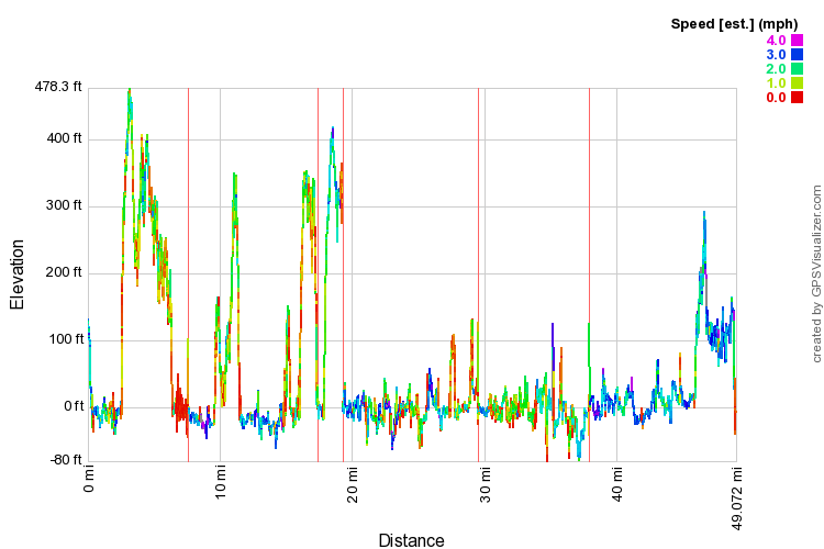
This profile is provided by GPS Visualizer
Coordinates and other details
| • Mileage: | 47.2 Miles |
| • Elevation Gain: | 7573 feet |
| • Time: | 22:23:34 |
| • Speed: | 2.05 MPH |
| • Trailhead Coordinates: | 47 44.959'N, 124 24.515W' |
If you would like to use this info with your GPS unit, the full GPX file is here.
If you want to view this in Google Earth, you can download the KMZ files of the track and topographic overlay.


