As a final warm-up backpack/gear check for our 50-mile high-adventure activity this summer, BSA troop 655 packed to Goat Lake in the Henry M. Jackson Wilderness. This is one of the more popular hikes along the Mountain Loop Highway, so we worried about how busy it would be at the campground. When we arrived at the trailhead, there were five vehicles there, but when we got to the main campsite, it was completely empty. A couple of backpackers set up farther down along the lake, but we had the main site to ourselves. The normal crowds may have been deterred by the grey skies, but fortunately, we were able to arrive at the campground right as the sun set, set up our tents, and cook our dinner without any rain at all. We enjoyed the dehydrated meals that we had learned about during our last couple of scout meetings. Thanks to Aaron McCain for preparing our delicious fare!
Around 4am, the clouds settled right on top of us and the rain started coming down. We were forced us to make breakfast and break camp in a light rain that nonetheless managed to soak all of our gear. By the time we hit the trail, however, the rain had stopped allowing us to make our trip back to the trailhead along tumbling Elliot Creek more enjoyable, even if we were faced with increasingly muddy hiking conditions. Unfortunately, the weather wasn't ideal for taking good pictures, but here is an album that contains some shots of the scenery and the scouts in action.

Evening Reflection on Goat Lake.
GPS Info
We collected all of the following data from our GPS unit during the adventure:Maps
Elevation Profile
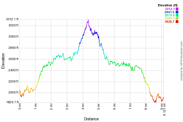
This profile is provided by GPS Visualizer
Coordinates and other details
| 9.1 Miles 4:33:14 (total), 4:05:32 (moving) 2.00 MPH (total), 2.23 MPH (moving) 48 03'13.1"N 121 24'46.4"W |
If you would like to use this info with your GPS unit, the full GPX file is here.
If you want to view this in Google Earth, you can download the KMZ files of the track and topographic overlay.


