Saturday, August 3, 2013

Spider Gap - Buck Creek Loop

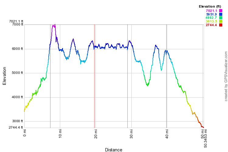
Mike went with the varsity scouts of troop 525 on a 50-mile backpack trip to the Glacier Peak Wilderness in the Cascade Mountains this Summer.  The group consisted of 8 varsity scouts, and two adult leaders.  The group covered 50.3 miles and 13,300 feet of elevation gain in five days.

Sunrise on Glacier Peak reflected in Image Lake


Report

Day 1: After a 3+ hour drive to the Phelps Creek Trailhead, we were all ready to stretch our legs on the slight grade up the creek basin.  At Leroy Creek, we stopped for lunch and a quick dip in the stream.  At this point, Dave Christie, who had come with us for a day hike, turned back, and we continued on our way to Spider Meadow.  Past the meadow, it was a tough grind of switchbacks we had to overcome to reach an amazingly beautiful campsite at the base of Spider Glacier.  (Start time: 9:48am, End Time: 5:15pm.)

Day 2: After waking up before sunrise, we again enjoyed the scenary from our campsite, retrieved the food we hung off a cliff to protect from wildlife, packed up camp, and began the ascent up Spider Glacier.  We were so glad to be fresh climbing up a steep grade of snow to climb 800 feet to Spider Gap.  Once all 8 scouts were accounted for, we descended the equally steep snowfield down to Lyman Basin.  The beauty of Upper Lyman Lake beckoned to us, so we stopped for a brisk swim.  Refreshed, we continued on to Lyman Lake and then proceeded up the long climb past meadows awash with wildflowers to Cloudy Pass, where we stopped for a photo op and a decent rest for the final push along Miners Ridge.  After a full day of hiking, we enjoyed the final rays of sun on Glacier Peak and descended into camp while enjoying the final colors of the sunset.  (Start time: 9:23am, End Time: 9:03pm.)

Day 3: After two grueling days of hiking, we opted to stay at our Image Lake campsite for two nights to let some of the less healthy members of our party recover on hump day.  We took side trips to Miners Ridge LookoutImage Lake, and saw a curious marmot aprising our group and another one enjoying the view from an interesting perch. Due to an early thunderstorm that rolled in, we all tucked ourselves in pretty early, which was a blessing, since we were going to need to be fresh for a long and tough day four.  (Start time: 9:31am, End Time: 5:04pm.)

Day 4: Having retired pretty early, I woke up around 5:15am and figured I'd take the opportunity to walk over to Image Lake to watch the sun rise on Glacier Peak.  Thanks to the thunderstorm the night before, the skies cleared up, and the haze was gone, allowing for some great reflections of the peak on the lake.  After packing up, we headed back down Miners Ridge and dropped into Miners Creek before making the ascent to Middle Ridge.  The 1800-foot climb was a kicker that can only be described by the carnage found at the summit.  We were encouraged that the worst was behind us as we descended to Small Creek, but were completely unaware that a similarly graded climb up 1100 feet to Buck Creek Pass still lay ahead of us.  Along the way, we would say farewell to Glacier Peak shortly before arriving at our foggy campsite. (Start time: 9:05am, End Time: 5:25pm.)

Day 5: Waking up to a soggy camp, we packed up as quickly as we could and began the descent to the Chiwawa River trailhead.  The fog insisted on keeping Glacier Peak hidden from us on our final day, but we still enjoyed occasional glimpses of the scenery around us.  Crossing the Chiwawa River was a welcomed indication that we were on the home stretch.  The boys really booked it on this day... I hardly ever saw them ahead on the trail.  I suspect it was because everyone was thinking about burgers and fries at Zeke's drive-in on the way back home, which has become a mandatory ending to these backpack trips this summer.  (Start time: 8:18am, End Time: 1:08pm.)

Final Thoughts

I think I can speak for the whole group that the trip was an amazing experience.  We all came to commune with the beauty of nature like never before, and gained a renewed gratitude for the Earth that God created for us.  It was appropriate that we read through the entire booklet, The Holy Temple, by Boyd K. Packer.  We all made a symbolic connection with the temple-like nature of Glacier Peak Wilderness and learned more about the purpose of temples.  Unfortunately, one member of our group, Hollan, was quite ill the entire trip and had a hard time holding down much food.  While he was able to stay hydrated, he wasn't able to consume many calories.  That he was able to hike nearly 50 miles, climb over 10,000 feet of elevation, and carry a backpack in the meantime with enough energy and strength is nothing short of a miracle.  I trust that the prayers offered and the blessing of health that he received were contributing factors to his safe return from the wilderness.  I am certain that many testimonies of God's truths were strengthened, including my own!

Photos

Here is a collection of online photos.  Other pictures were taken by David Mann and Dave Christie as well.

GPS Info

Here is the GPS data collected during the trip:

Maps


Elevation Profile


Coordinates and other details: 

Day OneDay TwoDay ThreeDay FourDay Five
Mileage7.3 Miles12.3 Miles9.3 Miles10.9 Miles10.5 Miles

Moving Time:

3:10:09 5:49:353:28:375:23:534:16:47

Average Moving Speed:

2.3 MPH2.1 MPH2.7 MPH2.0 MPH2.5 MPH

Elevation Gain:

3077 Feet3641 Feet2214 Feet3507 Feet874 Feet

Trailhead Coordinates:

N48 04.959, W120 50.097N48 04.337, W 120 51.042

If you would like to use this info with your GPS unit, the full GPX file is here.
If you want to view this in Google Earth, you can download the KMZ files of the track  and topographic overlay.

Ross Lake Canoe Trip

Mike and Raymond went with the varsity scouts of troop 525 on a 50-mile canoe trip to Ross Lake National Recreation Area, which is administered by North Cascades National Park.  The group consisted of nine varsity scouts, and three adult leaders, the largest allowable group by national park regulations, since this is considered a backcountry lake.  (The only road access is from a long dirt road on the Canadian side of the lake.)  While distances varied, based on the actual route taken by each canoe, the group averaged more than 51 miles in six days of paddling. 


Canoes moored at Ponderosa Campground on Ross Lake 


Report

Day 1:  We left church at 5:00am and headed to the North Cascades National Park wilderness information center in Marblemount to secure our campsites.  While we didn't get our first choice of campgrounds for the first two days of the trip, the replacement campgrounds (McMillan and Ponderosa) were pretty nice camps as well.  We loaded the canoes at the Colonial Creek boat launch and headed out onto glacial-fed Diablo Lake with its turquoise-colored waters.  Passing the last rocky point of the lake, we meandered up the Skagit River en route to the portage up to Ross Lake.  After putting in on Ross Lake, the Powells connected (literally) with Cody and Eric to make a very stable catamaran.  After enjoying the scenic mountain views near the dam, we headed north to our destination, McMillan campground.  (Start time: 9:18am, End Time: 2:00pm.)

Day 2:  Enjoying near glass-like conditions, we continued our journey up the lake.  As temperatures rose, the guys found a shady spot to cool off... and decided to jump into the lake from the East Bank Trail.  After spotting one of the bridges along the trail, we couldn't resist the opportunity to explore Devil's Creek, where the temperature was noticeably cooler in the narrow canyon.  After passing through a minor debris clog, we quickly came to the end of our journey at some rapids.   After some great photo ops, we turned our canoes around, and headed back out through the narrow channel back out towards the lake and on to Ponderosa Campground.   (Start time: 10:27am, End Time: 2:30pm.)

Day 3: Starting out with perfectly sunny skies and calm conditions, we prepare ourselves for one of the longest paddle days of the trip.  This was the only day we decided to stop for lunch along the way, and as soon as we rounded the point at Ponderosa we were able to make visual contact with our picnic spot at Little Beaver Campground.  The problem was that it made for some tedious paddling, since we were staring at the same spot for nearly two hours.  Three of the canoes headed for the rocky shoreline to explore something less monotonous.  Rewarded with vistas of waterfalls,  they made it into the picnic area just about fifteen minutes later than the first group.  After lunch, a quick dip, and some incredible views, we continued on our way towards the north end of the lake near the Canadian border.  The amenities at Silver Creek Campground were the least convenient of the entire trip.  Lacking the space to safely store all of our food and garbage, we decided to bear-proof the trash with a "garbage canoe" that Cody and Eric anchored off shore.  We gave Bro. Christie a priesthood blessing, since he had developed some tendonitis in his arm that threatened his ability to paddle back across the lake. (Start time: 8:58am, End Time: 2:31pm.)

Day 4:  Well, what do you know... it's another amazing day for paddling on Lake Ross.  Breaking out the hardware for the catamaran,  the Powells hooked up with Bro. Christie and Daniel this time, in case they needed any help paddling for the day.  During a quick pit stop, we snapped a couple of photos of the Little Beaver River before heading on to Arctic Canyon Falls and No Name Creek Falls.  With Cat Island in sight, we made a dash to our next campground.  Since the group campsite was at the top of the island, it was a bit of a climb, but we enjoyed one of our longest afternoons there, where swimming, exploring, cliff jumping, deer-following, napping, card-playing and eating (of course) were a few of the selected activities of the group.  (Start time: 8:40am, End Time: 11:50pm.)

Day 5: After a hearty breakfast, we packed up the canoes for our penultimate day of adventure.  Once the group was ready to launch, we headed straight for Lightening Creek, where a few of the young men got their blood pumping from a morning cliff jump. After heading under the second East Bank Trail bridge, a couple of the canoes dashed across the lake to check out Skymo Creek Falls while others stopped off at Ponderosa for yet another cliff jump to cool off for the final stretch to our last campsite, Big Beaver Campground, where a threatening thunderstorm had everyone scrambling for their rain flies.  When the lake grew too rough to swim in, the guys passed the time with a rousing game of poker using Cheez-It. (Start time: 8:30am, End Time: 12:41pm.)

Day 6:  After seeing the whitecaps on the lake during the threatening thunderstorm the night before, we were pleasantly surprised to see a sixth straight day of calm conditions.  Bro. Powell said, "If you would have told me before this trip that we'd have six days of glass on this lake, I wouldn't have believed it."  It was apparent that everyone was eager to get home, because we busted a pace of 3.2MPH (we were consistently paddling between 2.4MPH and 2.6MPH for the other five days.)  Hearing the cars on Highway 20 for the first time in nearly a week made the end seem so much more real. As we left the Skagit River onto Diablo Lake, it was a straight sprint to the end at the boat launch.  On the way back home, we stopped at King Charley's in Snohomish, for burgers, fries, and shakes.  (Start time: 9:01am, End Time: 1:14pm.)

Final Thoughts

I think I can speak for the whole group that the trip was a fun experience.  We enjoyed the peace of a wilderness lake, even with the occasional motor boat passing by.  At times, we could look for miles in every direction, and not spot anyone else in our entire field of view.  Similar to last year's 50-mile hike to Glacier Peak Wilderness, the trip was not without incident.  This year, Bro. Christie suffered from tendonitis that jeopardized his ability to paddle safely.  Also like last year, a priesthood blessing was offered at the farthest distance into the trip.  Some may consider it a coincidence that we had to call upon priesthood power 25 miles into both trips, but what better way for the Lord to call upon the faith of the young men and scout leaders alike to demonstrate his power in safely guiding the group back home.  Bro. Christie expressed gratitude that he felt an increased amount of energy, and with his son, Eric, to help him paddle back to Colonial Creek, they often were the fastest boat, leading the group for much of the final 25 miles.  The fact that a paddler with a swollen forearm could effectively do laps around the rest of us is compelling evidence of priesthood power.

Photos

Here is a collection of online photos.  Other pictures were taken by Dave Christie and Rick Powell as well.

GPS Info

Here is the GPS data collected during the trip:

Maps


This Google Map is provided by GPS Visualizer

Speed Profile


Coordinates and other details:


Day One
(includes portage)
Day Two Day Three Day Four Day Five Day Six
(includes portage)
Mileage 9.0 miles 7.5 miles 9.1 miles 7.5 miles 9.5 miles 9.8 miles

Moving Time:

3:31:29 3:28:39 3:30:23 2:57:20 3:57:13 3:00:11

Average Moving Speed:

2.5 MPH 2.2 MPH 2.6 MPH 2.5 MPH 2.4 MPH 3.2 MPH

Starting Coordinates:

48.6902, -121.0958 48.7731, -121.0343 48.8578, -121.0203 48.9681, -121.1000 48.8843, -121.0384 48.7752, -121.0583

If you would like to use this info with your GPS unit, the full GPX file is here.
If you want to view this in Google Earth, you can download the KMZ files of the track.

Chain Lakes Loop

On the first day of autumn, Mike was able to get in one final Saturday of good weather for a day hike to give him over 50 miles of hiking in...