Rarely do we travel just 400 total miles on any of our vacations, but with such a compelling destination so close to us, we took the short drive to Mount Baker and spent a week of camping, hiking, driving, geocaching, and exploring. We had sunny skies all week with high temperatures in the seventies. Mia was even able to take some time off of work, so she and her boyfriend, Chris, joined us for the week as well. It was unanimous that Mounts Baker and Shuksan do not disappoint. They are truly jaw-droppingly beautiful mountain peaks.
We stayed at the lovely and small Douglas Fir campground near Glacier, WA and enjoyed sleeping to the tumbling sounds of the North Fork Nooksack River. It was the perfect base camp for launching our activities along the 20-mile scenic portion of the Mount Baker Scenic Byway. Mount Shuksan behind Picture Lake. Arguably, this is one of most photographed scenes in all of Washington State, as indicated by the number of wall calendars it finds its way into.
Hiking
We hiked nearly 24 miles in five days. That's not even close to a Lewis family vacation record, but when you're in volcano and glacier territory like this, elevation gain is to be expected almost everywhere. While my GPS claimed that we climbed just over 10000 feet, I've noticed that GPS trackers (at least the ones that I have owned) don't do a great job in conveying elevation accurately. Instead, I relied on my Fitbit Blaze (which uses atmospheric pressure change to track elelvation) to determine that we climbed about 4660 feet during the week.
Here are the details on our individual hikes:
| Hike | Distance (miles) | Elevation Gain (feet) |
| Artist Point | 0.5 | 99 |
| Bagley Lakes | 1.7 | 493 |
| Boyd Creek | 0.4 | 122 |
| Canyon Creek | 1.3 | 291 |
| Fire and Ice Trail | 0.7 | 138 |
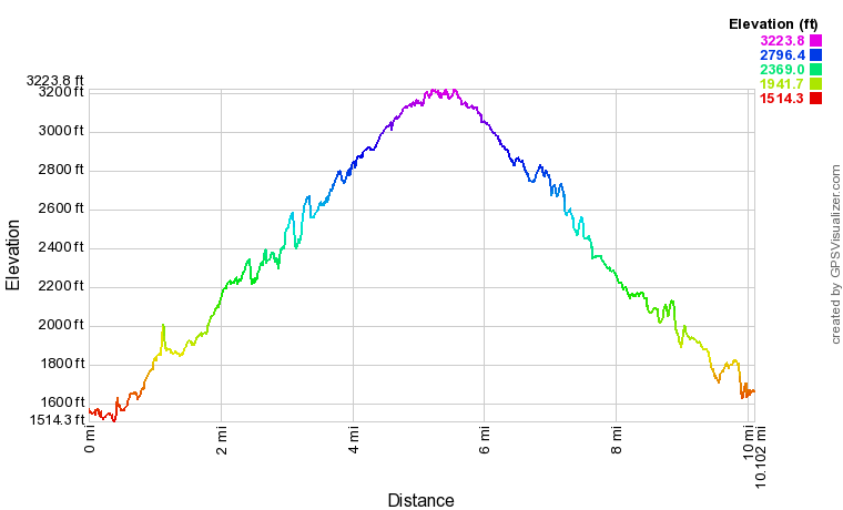
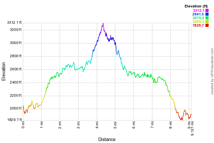
| Heliotrope Ridge | 5.3 | 2835 |
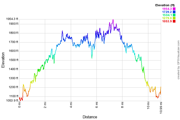
| Horseshoe Bend | 3.4 | 2050 |
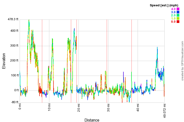
| Nooksack Cirque | 8.5 | 3487 |
| North Fork Nooksack Research Area | 0.4 | 196 |
| Thompson Creek Ridge | 0.9 | 329 |
| TOTALS | 23.1 | 10040 |
* Elevation Gain does not convey total climb (i.e. ups and downs along the trail)
Here is a link to our GPX file and KML file for Google Earth. This topographic overlay also shows the steep terrain of the area as well. GPS Visualizer created this Google map of all of our hikes as well.
Highlights
- The scenery is so spectacular in this area, we can't believe that the powers that be didn't include Mount Baker inside of the North Cascades National Park boundary. At least the Heather Meadows area should've been included, since it is so close to the border.
- The Douglas Fir campground was an awesome place to stay. There are some really spacious sites right along the North Fork Nooksack. The camp hosts did a great job of keeping the place tidy (including the pit toilets!)
- Not a drop of rain for an entire week in the Pacific Northwest. In fact, we barely saw any clouds at all!
- This was one of the quietest campgrounds we have ever stayed at. Perhaps it helps that the raging North Fork Nooksack River ran through the campground, but even so, all of the campers were rather quiet. Perhaps everyone comes here to enjoy the reverence of the area.
Lowlights
- Insects, insects, and more insects. The silver lining is that they weren't doing a whole lot of biting, but the flies were out there on almost every trail we hiked on. Luckily, we were spared at the campground.
- Surprisingly, we came across very little wildlife. We saw birds, insects, toads, insects, chipmunks, and insects. Oh yeah, we also saw insects.
- Temperatures in the mid-70s is ok when you're hiking in the shade of forest trees, but when trails opened up, the sun could seem a little too warm while wandering up steep mountain trails.
- Because of the massive winter in the area, there were still a lot of trails closed due to snow and roads closed due to washouts. We really wanted to do a couple of other hikes (e.g. Excelsior Peak, Chain Lakes) which were either too snowy, or completely inaccessible. At the Heliotrope Ridge trail, we were unable to reach the Coleman Glacier due to the swift moving Heliotrope Creek. We measured it as too deep and swift to safely cross.
Favorites
Here's what each family member said was their favorite part of the trip:
| Raymond: | Artist Point | Incredible close-up views of Mounts Baker and Shuksan |
| Amelia: | Artist Point | Incredible close-up views of Mounts Baker and Shuksan |
| Chris: | Heliotrope Ridge Trail | Mushroom Heaven! (Chris loves to hunt for mushrooms) |
| Suzanne: | Picture Lake | 360 degrees of mountains seem to circle this tiny reflective lake. The picture of Mount Shuksan from here is one of the most photographed mountain scenes in the world! |
| Mike: | Artist Point | Incredible close-up views of Mounts Baker and Shuksan |
It's not too often that three of us agree on the same highlight, but that's probably a testament to the splendor of Artist Point.
Photos
We took nearly 250 pictures. After converting panoramas and weeding out the worst images, we were able to boil it down to 180 useful scenes. You can take a look at all of these albums here.